
فائل:Australia Victoria East Gippsland Shire location map.svg

Size of this PNG preview of this SVG file: ۵۳۳ × ۳۵۳ پکسلز. دوجے ریزولوشنز: ۳۲۰ × ۲۱۲ پکسلز | ۶۴۰ × ۴۲۴ پکسلز | ۱,۰۲۴ × ۶۷۸ پکسلز | ۱,۲۸۰ × ۸۴۸ پکسلز | ۲,۵۶۰ × ۱,۶۹۵ پکسلز ۔
اصل فائل (ایس وی جی فائل، پکسل:۵۳۳ × ۳۵۳، فائل سائز: ۸۹۳ کلوبائٹ)
| تفصیل |
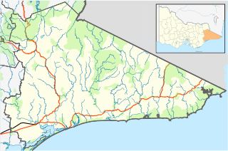
English: Blank map of w:East Gippsland Shire, Victoria, Australia, with the following information shown:
Geographic limits:
|
||
| سروت | آپݨا کم + VicMap Lite | ||
| لکھاری | Cassowary |

فائل دی تریخ
فائل نو اس ویلے دی حالت وچ ویکھن واسطے تاریخ/ویلے تے کلک کرو۔
| تریخ تے ویلہ | نکی مورت | پاسے | ورتن والا | تیپّݨی کرو | |
|---|---|---|---|---|---|
| موجودہ | ۱۷:۵۶, ۱۷ فروری ۲۰۱۱ | | ۵۳۳ × ۳۵۳ (۸۹۳ کلوبائٹ) | Cassowary | {{Information |Description ={{en|1=Blank map of w:East Gippsland Shire, Victoria, Australia, with the following information shown: * LGA boundaries * Coastline, lakes and rivers * Roads and railways * Urban areas * Parks Geographic limits: * North |
فائل دی ورتوں
تھلے دتے گئے 1 صفحے اس فائل نال جُڑدے نیں
فائل ویاپک ورتوں
ایہہ دوجے وکیاں ایس فائل نوں ورتدے نیں –
- ar.wikipedia.org تے ورتوں
- ceb.wikipedia.org تے ورتوں
- en.wikipedia.org تے ورتوں
- Shire of East Gippsland
- Goongerah, Victoria
- Mallacoota, Victoria
- Bairnsdale
- Lakes Entrance, Victoria
- Paynesville, Victoria
- Raymond Island
- Orbost
- Gabo Island
- Swifts Creek
- Buchan, Victoria
- Cann River, Victoria
- Omeo
- Nowa Nowa, Victoria
- Ensay, Victoria
- Benambra, Victoria
- Bruthen, Victoria
- Metung
- Newmerella, Victoria
- Cassilis, Victoria
- Bemm River, Victoria
- Genoa, Victoria
- Rotamah Island
- Tullaberga Island
- Omeo & District Football League
- East Gippsland Football League
- Swan Reach, Victoria
- Marlo, Victoria
- Johnsonville, Victoria
- Nicholson, Victoria
- Fernbank, Victoria
- Template:Towns in East Gippsland Shire
- W Tree, Victoria
- Orbost railway station
- Cape Conran
- Lindenow, Victoria
- Anglers Rest, Victoria
- Module:Location map/data/Australia Victoria Shire of East Gippsland/doc
- Bonang Road
- Tambo Crossing, Victoria
- Eagle Point, Victoria
- Suggan Buggan, Victoria
- Eastwood, Victoria
- Lake Tyers Mission
- Lucknow, Victoria
- The Skerries (Victoria)
- Wy Yung, Victoria
- Module:Location map/data/Australia Victoria Shire of East Gippsland
ایس فائل دا ویکھو ہور جگت ورتن .