
فائل:Constantinople mediaeval map.jpg
ایس وکھالے دا ناپ: ۴۰۴ × ۵۹۹ پکسلز۔ دوجے ریزولوشنز: ۱۶۲ × ۲۴۰ پکسلز | ۳۲۴ × ۴۸۰ پکسلز | ۵۱۸ × ۷۶۸ پکسلز | ۱,۰۵۴ × ۱,۵۶۲ پکسلز ۔
اصل فائل (۱,۰۵۴ × ۱,۵۶۲ پکسلز, فائل حجم: ۷۹۲ کلوبائٹ, MIME type: image/jpeg)
خلاصہ
| تفصیل |
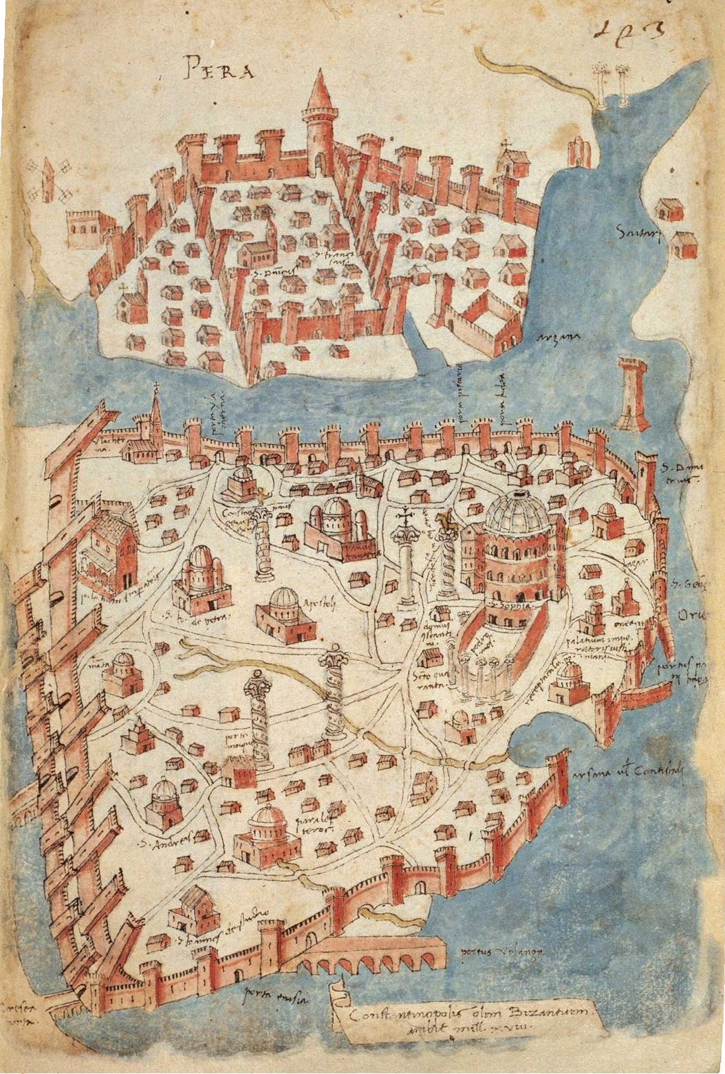
English: Mediaeval map of Constantinople Deutsch: Mittelalterliche Karte von Konstantinopel. Map by Cristoforo Buondelmonti, a Florentine cartographer, from the volume Liber insularum archipelagi (Venice copy) |
|||||
| تریخ | 1420s-1430s | |||||
| سروت | https://sakipsabancimuzesi.org/tr/object/istanbul-haritasi | |||||
| لکھاری | Cristoforo Buondelmonti | |||||
| اجازت (فائل نوں دوبارہ ورتنا) |
|
|||||
| دوجے ورژن |
|
|||||
.jpg)
.jpg)
_by_Florentine_cartographer_Cristoforo_Buondelmonte.jpg)
فائل دی تریخ
فائل نو اس ویلے دی حالت وچ ویکھن واسطے تاریخ/ویلے تے کلک کرو۔
| تریخ تے ویلہ | نکی مورت | پاسے | ورتن والا | تیپّݨی کرو | |
|---|---|---|---|---|---|
| موجودہ | ۱۲:۳۵, ۸ جنوری ۲۰۲۱ | | ۱,۰۵۴ × ۱,۵۶۲ (۷۹۲ کلوبائٹ) | Nanahuatl | better resolution |
| ۱۷:۰۲, ۱ مئی ۲۰۰۸ |  | ۴۵۰ × ۶۶۵ (۵۴ کلوبائٹ) | H-stt | http://www.metmuseum.org/explore/byzantium_III/images_large/BYZ1911-lg.jpg | |
| ۰۳:۳۲, ۱۳ اپریل ۲۰۰۸ |  | ۲۹۶ × ۴۴۱ (۱۶۰ کلوبائٹ) | Bender235 | {{Information |Description={{en|Mediaeval map of Constantinople}}<br />{{de|Mittelalterliche Karte von Konstantinopel.}} |Source=German Wikipedia |Date= |Author= |Permission=Public domain |other_versions= }} |
فائل دی ورتوں
تھلے دتے گئے 1 صفحے اس فائل نال جُڑدے نیں
فائل ویاپک ورتوں
ایہہ دوجے وکیاں ایس فائل نوں ورتدے نیں –
- ar.wikipedia.org تے ورتوں
- ast.wikipedia.org تے ورتوں
- az.wikipedia.org تے ورتوں
- be-tarask.wikipedia.org تے ورتوں
- be.wikipedia.org تے ورتوں
- bs.wikipedia.org تے ورتوں
- ca.wikipedia.org تے ورتوں
- ce.wikipedia.org تے ورتوں
- cs.wikipedia.org تے ورتوں
- cv.wikipedia.org تے ورتوں
- da.wikipedia.org تے ورتوں
- de.wikipedia.org تے ورتوں
- Istanbul
- 1422
- 1203
- Vierter Kreuzzug
- Republik Venedig
- Wikipedia:Hauptseite/Jahrestage/April
- Pera
- Wikipedia:Hauptseite/Jahrestage/April/13
- Belagerung von Konstantinopel (1422)
- Benutzer:GerardM/Battles including the Ottoman Empire
- Wikipedia:Hauptseite/Jahrestage/Monat
- Wikipedia:Hauptseite/Archiv/13. April 2024
- el.wikipedia.org تے ورتوں
- en.wikipedia.org تے ورتوں
- eo.wikipedia.org تے ورتوں
- es.wikipedia.org تے ورتوں
- eu.wikipedia.org تے ورتوں
- fi.wikipedia.org تے ورتوں
- fo.wikipedia.org تے ورتوں
- fr.wikipedia.org تے ورتوں
- gv.wikipedia.org تے ورتوں
ایس فائل دا ویکھو ہور جگت ورتن .