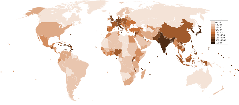
فائل:Countries by population density.svg

Size of this PNG preview of this SVG file: ۸۰۰ × ۳۵۳ پکسلز. دوجے ریزولوشنز: ۳۲۰ × ۱۴۱ پکسلز | ۶۴۰ × ۲۸۲ پکسلز | ۱,۰۲۴ × ۴۵۲ پکسلز | ۱,۲۸۰ × ۵۶۵ پکسلز | ۲,۵۶۰ × ۱,۱۲۹ پکسلز | ۶,۰۰۰ × ۲,۶۴۷ پکسلز ۔
اصل فائل (ایس وی جی فائل، پکسل:۶,۰۰۰ × ۲,۶۴۷، فائل سائز: ۱.۶۲ میگابائٹ)
فائل دی تریخ
فائل نو اس ویلے دی حالت وچ ویکھن واسطے تاریخ/ویلے تے کلک کرو۔
| تریخ تے ویلہ | نکی مورت | پاسے | ورتن والا | تیپّݨی کرو | |
|---|---|---|---|---|---|
| موجودہ | ۰۴:۳۳, ۲۲ دسمبر ۲۰۱۱ |  | ۶,۰۰۰ × ۲,۶۴۷ (۱.۶۲ میگابائٹ) | Quibik | added transparency |
| ۱۸:۴۳, ۲۰ فروری ۲۰۱۱ |  | ۶,۰۰۰ × ۲,۶۴۷ (۱.۶۲ میگابائٹ) | Erik del Toro Streb | typographically corrected | |
| ۰۷:۲۲, ۷ جنوری ۲۰۰۸ |  | ۶,۰۰۰ × ۲,۶۴۷ (۱.۶۲ میگابائٹ) | Briefplan~commonswiki | {{Information |Description=A map of the world, with colours to highlight the population density of each country or territory. Numbers on the legend are in people per km<sup>2</sup>, and all countries smaller than 20,000 km<sup>2</sup> are represented by a |
فائل دی ورتوں
تھلے دتے گئے 1 صفحے اس فائل نال جُڑدے نیں
فائل ویاپک ورتوں
ایہہ دوجے وکیاں ایس فائل نوں ورتدے نیں –
- af.wikipedia.org تے ورتوں
- ar.wikipedia.org تے ورتوں
- arz.wikipedia.org تے ورتوں
- ast.wikipedia.org تے ورتوں
- av.wikipedia.org تے ورتوں
- awa.wikipedia.org تے ورتوں
- azb.wikipedia.org تے ورتوں
- az.wikipedia.org تے ورتوں
- ba.wikipedia.org تے ورتوں
- be.wikipedia.org تے ورتوں
- bg.wikipedia.org تے ورتوں
- bs.wikipedia.org تے ورتوں
- ca.wikipedia.org تے ورتوں
- ckb.wikipedia.org تے ورتوں
- cs.wikipedia.org تے ورتوں
- cy.wikipedia.org تے ورتوں
- de.wikipedia.org تے ورتوں
- de.wikiversity.org تے ورتوں
- diq.wikipedia.org تے ورتوں
- dsb.wikipedia.org تے ورتوں
- en.wikipedia.org تے ورتوں
- eo.wikipedia.org تے ورتوں
- es.wikipedia.org تے ورتوں
- eu.wikipedia.org تے ورتوں
- fi.wikipedia.org تے ورتوں
- fr.wikipedia.org تے ورتوں
ایس فائل دا ویکھو ہور جگت ورتن .
