
فائل:Four corners.jpg
ایس وکھالے دا ناپ: ۴۶۵ × ۵۹۹ پکسلز۔ دوجے ریزولوشنز: ۱۸۶ × ۲۴۰ پکسلز | ۳۷۲ × ۴۸۰ پکسلز | ۵۹۶ × ۷۶۸ پکسلز | ۷۹۴ × ۱,۰۲۴ پکسلز | ۱,۵۸۹ × ۲,۰۴۸ پکسلز | ۴,۵۰۰ × ۵,۸۰۰ پکسلز ۔
اصل فائل (۴,۵۰۰ × ۵,۸۰۰ پکسلز, فائل حجم: ۴.۳۳ میگابائٹ, MIME type: image/jpeg)
خلاصہ
| تفصیل |
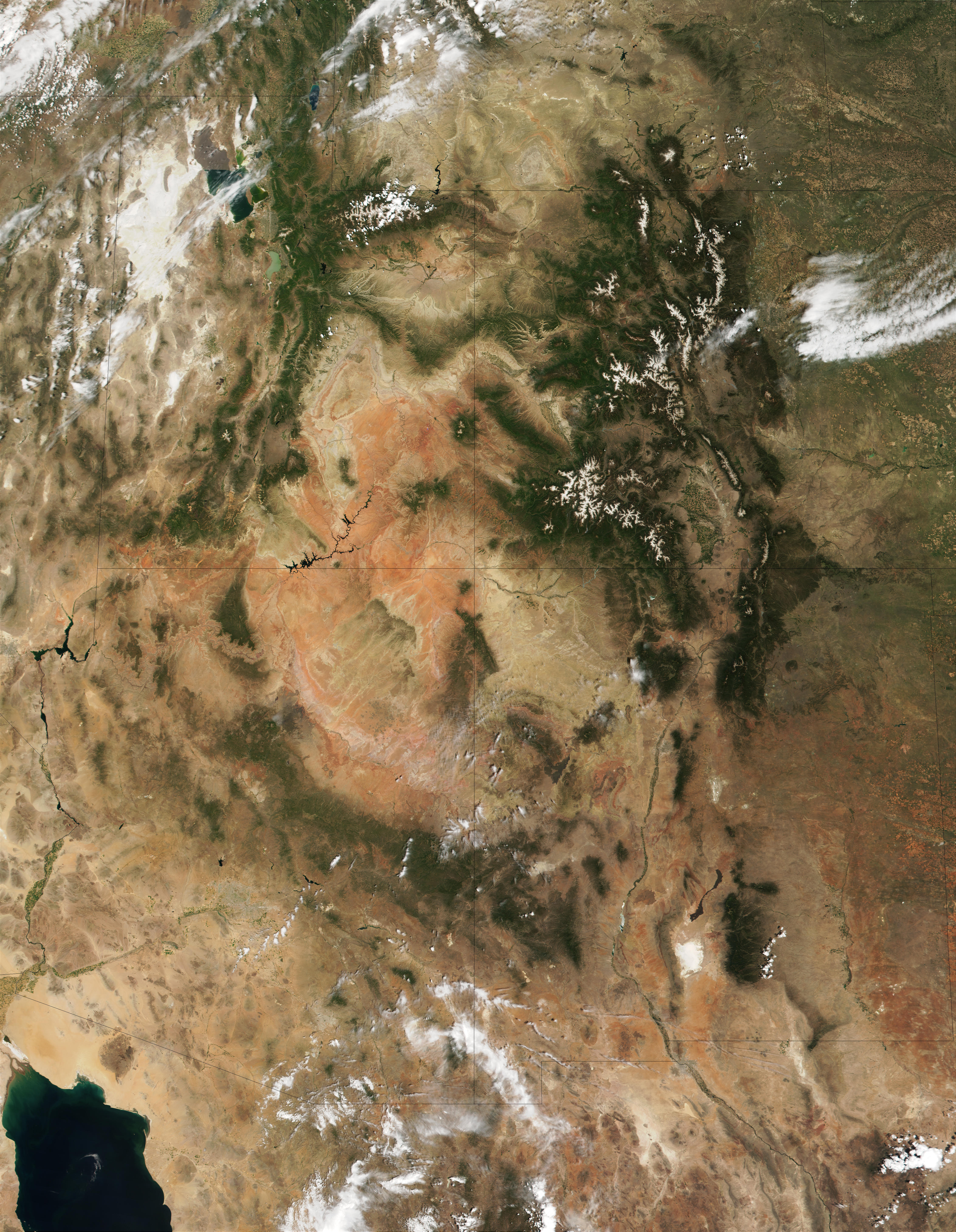
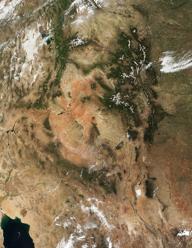
English: This MODIS true-color image is centered on the Four Corners region in the Southwest United States. Recognizable features include the forest-covered Rocky Mountains, which still have snow-covered peaks, running through Colorado and into New Mexico. To the west of Colorado is Utah, where the Great Salt Lake can be seen at the upper left. The Colorado Plateau, with its salmon-colored rocks, extends south from Utah into Arizona. The Grand Canyon of the Colorado River cuts westward through the mountains in northern Arizona. |
| تریخ | |
| سروت | http://visibleearth.nasa.gov/view_rec.php?id=1980 |
| لکھاری | Jacques Descloitres, MODIS Land Rapid Response Team (NASA) |
لائسنس –
| This file is in the public domain in the United States because it was solely created by NASA. NASA copyright policy states that "NASA material is not protected by copyright unless noted". (See Template:PD-USGov, NASA copyright policy page or JPL Image Use Policy.) | ||
 |
Warnings:
|
فائل دی تریخ
فائل نو اس ویلے دی حالت وچ ویکھن واسطے تاریخ/ویلے تے کلک کرو۔
| تریخ تے ویلہ | نکی مورت | پاسے | ورتن والا | تیپّݨی کرو | |
|---|---|---|---|---|---|
| موجودہ | ۱۶:۵۳, ۲۰ دسمبر ۲۰۱۰ | | ۴,۵۰۰ × ۵,۸۰۰ (۴.۳۳ میگابائٹ) | Orionist | high res from original source |
| ۱۸:۳۲, ۲۳ فروری ۲۰۰۵ |  | ۳۹۶ × ۵۱۱ (۱۸۷ کلوبائٹ) | Complex01 |
فائل دی ورتوں
تھلے دتے گئے 1 صفحے اس فائل نال جُڑدے نیں
فائل ویاپک ورتوں
ایہہ دوجے وکیاں ایس فائل نوں ورتدے نیں –
- ar.wikipedia.org تے ورتوں
- az.wikipedia.org تے ورتوں
- bg.wikipedia.org تے ورتوں
- bn.wikipedia.org تے ورتوں
- bs.wikipedia.org تے ورتوں
- ckb.wikipedia.org تے ورتوں
- en.wikipedia.org تے ورتوں
- es.wikipedia.org تے ورتوں
- et.wikipedia.org تے ورتوں
- fa.wikipedia.org تے ورتوں
- fi.wikipedia.org تے ورتوں
- he.wikipedia.org تے ورتوں
- hu.wikipedia.org تے ورتوں
- it.wikipedia.org تے ورتوں
- ja.wikipedia.org تے ورتوں
- ka.wikipedia.org تے ورتوں
- kk.wikipedia.org تے ورتوں
- kn.wikipedia.org تے ورتوں
- ko.wikipedia.org تے ورتوں
- lfn.wikipedia.org تے ورتوں
- lt.wikipedia.org تے ورتوں
- mk.wikipedia.org تے ورتوں
- ml.wikipedia.org تے ورتوں
- nl.wikipedia.org تے ورتوں
- pa.wikipedia.org تے ورتوں
- pl.wikipedia.org تے ورتوں
- pt.wikipedia.org تے ورتوں
- ru.wikipedia.org تے ورتوں
- si.wikipedia.org تے ورتوں
- sq.wikipedia.org تے ورتوں
- ta.wikipedia.org تے ورتوں
- vi.wikipedia.org تے ورتوں
- zh.wikipedia.org تے ورتوں