
فائل:Global Hawk 1.jpg

ایس وکھالے دا ناپ: ۸۰۰ × ۵۲۴ پکسلز۔ دوجے ریزولوشنز: ۳۲۰ × ۲۱۰ پکسلز | ۶۴۰ × ۴۱۹ پکسلز | ۱,۰۲۴ × ۶۷۱ پکسلز | ۱,۲۸۰ × ۸۳۸ پکسلز | ۳,۰۰۰ × ۱,۹۶۵ پکسلز ۔
اصل فائل (۳,۰۰۰ × ۱,۹۶۵ پکسلز, فائل حجم: ۲.۹۶ میگابائٹ, MIME type: image/jpeg)
خلاصہ
| تفصیل |
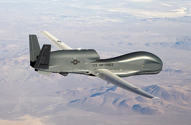
English: An RQ-4 Global Hawk unmanned aircraft like the one shown is currently flying non-military mapping missions over South, Central America and the Caribbean at the request of partner nations in the region. |
| تریخ | |
| سروت | http://www.af.mil/shared/media/photodb/photos/070301-F-9126Z-229.jpg |
| لکھاری | U.S. Air Force photo by Bobbi Zapka |
| دوجے ورژن | Derivative works of this file: Tasnim Infographic - The Falconry.jpg |
لائسنس –
This image or file is a work of a U.S. Air Force Airman or employee, taken or made as part of that person's official duties. As a work of the U.S. federal government, the image or file is in the public domain in the United States.
|
 |
فائل دی تریخ
فائل نو اس ویلے دی حالت وچ ویکھن واسطے تاریخ/ویلے تے کلک کرو۔
| تریخ تے ویلہ | نکی مورت | پاسے | ورتن والا | تیپّݨی کرو | |
|---|---|---|---|---|---|
| موجودہ | ۱۲:۱۵, ۶ مئی ۲۰۰۹ | | ۳,۰۰۰ × ۱,۹۶۵ (۲.۹۶ میگابائٹ) | DeffiSK~commonswiki | {{Information |Description={{en|1=An RQ-4 Global Hawk unmanned aircraft like the one shown is currently flying non-military mapping missions over South, Central America and the Caribbean at the request of partner nations in the region.}} |Source=http://ww |
فائل دی ورتوں
تھلے دتے گئے 1 صفحے اس فائل نال جُڑدے نیں
فائل ویاپک ورتوں
ایہہ دوجے وکیاں ایس فائل نوں ورتدے نیں –
- ar.wikipedia.org تے ورتوں
- مسيرة
- سلاح الجو
- بوابة:الحرب
- بوابة:طيران/صورة مختارة
- بوابة:طيران/صورة مختارة/5
- آر كيو-4 غلوبال هوك
- بوابة:طيران/أحداث تاريخية/أبريل في الطيران
- بوابة:طيران/أحداث تاريخية/أبريل في الطيران/24 أبريل
- قائمة الطائرات العسكرية النشطة في الولايات المتحدة
- بوابة:الحرب/مقالة مختارة/5
- بوابة:الحرب/مقالة مختارة/أرشيف
- برنامج الصواريخ الإيرانية
- سوم خرداد (نظام دفاع جوي)
- جناح الاستخبارات رقم 181
- 3 خرداد (نظام صاروخي للدفاع الجوي)
- ar.wikinews.org تے ورتوں
- azb.wikipedia.org تے ورتوں
- az.wikipedia.org تے ورتوں
- bs.wikipedia.org تے ورتوں
- ca.wikipedia.org تے ورتوں
- ckb.wikipedia.org تے ورتوں
- cs.wikipedia.org تے ورتوں
- da.wikipedia.org تے ورتوں
- de.wikipedia.org تے ورتوں
- de.wikinews.org تے ورتوں
- en.wikipedia.org تے ورتوں
- United States Air Force
- Northrop Grumman RQ-4 Global Hawk
- Surveillance aircraft
- Northrop Grumman
- Portal:Aviation/Selected picture
- Portal:Aviation/Selected picture/23
- User:Germinator15
- User:SunKider/sandbox
- User:Mrteeve/Sandbox2
- 2019 Iranian shoot-down of American drone
- User:Mrteeve/BigExpand
- User:Iamonwikimofo/sandbox/Joint Forces
- User:Iamonwikimofoos/sandbox
- User:Iamonwikimofoos
- en.wikiquote.org تے ورتوں
- es.wikipedia.org تے ورتوں
- et.wikipedia.org تے ورتوں
ایس فائل دا ویکھو ہور جگت ورتن .