
فائل:India Geographic Map.jpg

ایس وکھالے دا ناپ: ۶۲۲ × ۶۰۰ پکسلز۔ دوجے ریزولوشنز: ۲۴۹ × ۲۴۰ پکسلز | ۴۹۸ × ۴۸۰ پکسلز | ۷۹۷ × ۷۶۸ پکسلز | ۱,۰۶۲ × ۱,۰۲۴ پکسلز | ۱,۴۴۰ × ۱,۳۸۸ پکسلز ۔
اصل فائل (۱,۴۴۰ × ۱,۳۸۸ پکسلز, فائل حجم: ۸۰۹ کلوبائٹ, MIME type: image/jpeg)
| تفصیل |
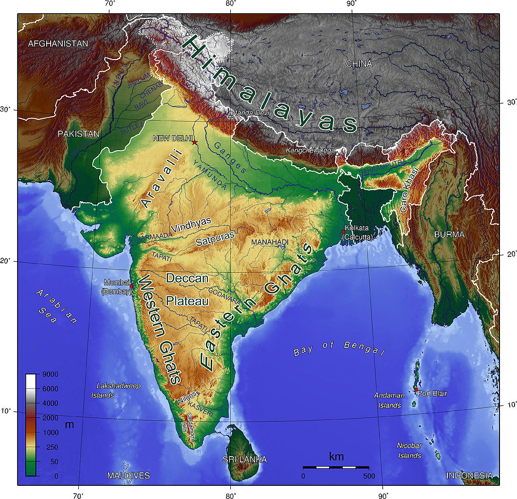
English: Map showing Mountains and Rivers of India |
| سروت | http://en.wikipedia.org/wiki/Image:India_Geographic_Map.jpg |
| لکھاری | mukesh Suthar palari |
| دوجے ورژن | hindi |

|
کاپی کرن، ونڈن تے بدلن دی ایس ڈوکومنٹ لئی اجازت دتی جاندی اے ایہناں GNU Free Documentation License, Version 1.2 شرطاں نال یا مگروں کسے وی چھپے ورین Free Software Foundation توں بنا کسے انویرینٹ سیکشن دے، ناں فرنٹ کور لکھت تے ناں بیک کور لکھت دے۔ لسنس دی اک کاپی سیکشن وچ ہیگی اے جہدا ناں اے GNU Free Documentation License۔ |
| ایس فائل نوں کریٹو کامنز Attribution 2.5 پولینڈ لائسنس دتا گیا. | ||
| ||
| اس لائسنس دا ٹیگ GFDL دے مطابق اس فائل چ پایا گیا اے licensing update۔ |
فائل دی تریخ
فائل نو اس ویلے دی حالت وچ ویکھن واسطے تاریخ/ویلے تے کلک کرو۔
| تریخ تے ویلہ | نکی مورت | پاسے | ورتن والا | تیپّݨی کرو | |
|---|---|---|---|---|---|
| موجودہ | ۰۵:۰۳, ۱۷ اکتوبر ۲۰۰۸ | | ۱,۴۴۰ × ۱,۳۸۸ (۸۰۹ کلوبائٹ) | Carlos-PCC | {{Information |Description=Map showing Mountains and Rivers of India |Source=http://en.wikipedia.org/wiki/Image:India_Geographic_Map.jpg |Date= |Author=Sagredo |Permission={{GFDL}} |other_versions= }} Category:Maps of India <!--{{ImageUpload|basic}}- |
فائل دی ورتوں
تھلے دتے گئے 5 صفحے اس فائل نال جُڑدے نیں
فائل ویاپک ورتوں
ایہہ دوجے وکیاں ایس فائل نوں ورتدے نیں –
- af.wikipedia.org تے ورتوں
- ar.wikipedia.org تے ورتوں
- ast.wikipedia.org تے ورتوں
- bh.wikipedia.org تے ورتوں
- bn.wikipedia.org تے ورتوں
- ca.wikipedia.org تے ورتوں
- cs.wikipedia.org تے ورتوں
- cs.wikiquote.org تے ورتوں
- da.wikipedia.org تے ورتوں
- de.wikipedia.org تے ورتوں
- en.wikipedia.org تے ورتوں
- es.wikipedia.org تے ورتوں
- fa.wikipedia.org تے ورتوں
- fi.wikipedia.org تے ورتوں
- fr.wikipedia.org تے ورتوں
- gu.wikipedia.org تے ورتوں
- hif.wikipedia.org تے ورتوں
- hi.wikipedia.org تے ورتوں
- hi.wikibooks.org تے ورتوں
- hu.wikipedia.org تے ورتوں
- io.wikipedia.org تے ورتوں
- it.wikibooks.org تے ورتوں
- ja.wikipedia.org تے ورتوں
- lv.wikipedia.org تے ورتوں
- mai.wikipedia.org تے ورتوں
- ml.wikipedia.org تے ورتوں
- mr.wikipedia.org تے ورتوں
ایس فائل دا ویکھو ہور جگت ورتن .