
فائل:India Madhya Pradesh location map.svg

Size of this PNG preview of this SVG file: ۸۰۰ × ۵۶۳ پکسلز. دوجے ریزولوشنز: ۳۲۰ × ۲۲۵ پکسلز | ۶۴۰ × ۴۵۰ پکسلز | ۱,۰۲۴ × ۷۲۰ پکسلز | ۱,۲۸۰ × ۹۰۰ پکسلز | ۲,۵۶۰ × ۱,۸۰۰ پکسلز | ۱,۰۴۱ × ۷۳۲ پکسلز ۔
اصل فائل (ایس وی جی فائل، پکسل:۱,۰۴۱ × ۷۳۲، فائل سائز: ۱۸۰ کلوبائٹ)
خلاصہ
| تفصیل |
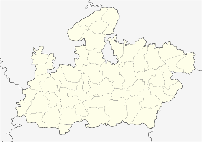
English: Locator map of Madhya Pradesh.
Geographical limits of the map:
Français : Carte de localisation du Madhya Pradesh, Inde. |
| تریخ | (UTC) |
| سروت | India_Madhya_Pradesh_locator_map.svg |
| لکھاری |
India_Madhya_Pradesh_locator_map.svg: user:Planemad
|
| دوجے ورژن |
|


| This is a retouched picture, which means that it has been digitally altered from its original version. Modifications: Cropped map of madhya pradesh. The original can be viewed here: India Madhya Pradesh locator map.svg:
|
لائسنس –
ایس فائل نوں کریٹو کامنز Attribution 2.5 پولینڈ لائسنس دتا گیا.
- تہانوں کھلھ اے:
- حصہ کرنا – کاپی، ونڈنا تے کم بھیجنا
- فیر رلانا – کم نوں فٹ کرنا
- تھلے دتیاں شرطاں نال:
- کس دے ناں – تسیں لازمی ایس کم دے بناں والے بارے دسو جنج اونے آکھیا اے یا جنج لسنس چ آکھیا گیا ہے۔
- اکو جہا شئیر کرو۔ – اگر تسیں بدلدے یا ایس کم تے بناندے تے بنن والے کم نوں اینج دے لسنس نال ای ونڈو گے۔
پہلا اپلوڈ دا ریکارڈ
This image is a derivative work of the following images:
- File:India_Madhya_Pradesh_locator_map.svg licensed with Cc-by-sa-3.0
- 2006-08-06T17:38:20Z Planemad 1639x1852 (768594 Bytes) {{WikiProject_India_Maps |Title=Madhya Pradesh locator map |Description=Locator map of the state of Madhya Pradesh, [[w:India|India]] with district boundaries. |Source=. |Date=August 6 2006 |Author=[[w:user:Nichalp]][[w:user
Uploaded with derivativeFX
| Annotations | This image is annotated: View the annotations at Commons |
فائل دی تریخ
فائل نو اس ویلے دی حالت وچ ویکھن واسطے تاریخ/ویلے تے کلک کرو۔
| تریخ تے ویلہ | نکی مورت | پاسے | ورتن والا | تیپّݨی کرو | |
|---|---|---|---|---|---|
| موجودہ | ۰۳:۲۶, ۲۶ فروری ۲۰۱۳ | | ۱,۰۴۱ × ۷۳۲ (۱۸۰ کلوبائٹ) | Milenioscuro | updated new districts, colors according german map workshop and the other India location maps |
| ۱۷:۱۹, ۲۵ نومبر ۲۰۱۰ |  | ۶۱۰ × ۴۴۰ (۱۴۶ کلوبائٹ) | Nayvik | Changed background color | |
| ۱۷:۱۳, ۲۵ نومبر ۲۰۱۰ |  | ۶۱۰ × ۴۴۰ (۱۴۶ کلوبائٹ) | Nayvik | {{Information |Description=Locator map of Madhya Pradesh.<br> Geographical limits of the map: * 28.0°N * 20.0°N * 84.0°E * 72.0°E |Source=*File:India_Madhya_Pradesh_locator_map.svg |Date=2010-11-25 12:11 (UTC) |Author=*[[:Fi |
فائل دی ورتوں
اس فائل نال جڑیا کوئی صفحہ نئیں۔
فائل ویاپک ورتوں
ایہہ دوجے وکیاں ایس فائل نوں ورتدے نیں –
- de.wikipedia.org تے ورتوں
- de.wikivoyage.org تے ورتوں
- en.wikipedia.org تے ورتوں
- eo.wikipedia.org تے ورتوں
- fa.wikipedia.org تے ورتوں
ایس فائل دا ویکھو ہور جگت ورتن .