
فائل:Map of Nicobar and Andaman Islands-en.svg

Size of this PNG preview of this SVG file: ۲۶۳ × ۵۹۸ پکسلز. دوجے ریزولوشنز: ۱۰۵ × ۲۴۰ پکسلز | ۲۱۱ × ۴۸۰ پکسلز | ۳۳۷ × ۷۶۸ پکسلز | ۴۵۰ × ۱,۰۲۴ پکسلز | ۹۰۰ × ۲,۰۴۸ پکسلز | ۹۰۶ × ۲,۰۶۰ پکسلز ۔
اصل فائل (ایس وی جی فائل، پکسل:۹۰۶ × ۲,۰۶۰، فائل سائز: ۶۲۱ کلوبائٹ)
خلاصہ
| تفصیل | |
| تریخ | |
| سروت | آپݨا کم. Self-made in Inkscape. Based on the 1976 CIA Indian Ocean Atlas (Andaman nicobar 76.jpg); bathymetry and topography from SRTM30_PLUS. |
| لکھاری | Oona Räisänen (Mysid) |
| دوجے ورژن |
Derivative works of this file: |
| SVG genesis |
لائسنس –
میں، اس کم دے کاپیرائٹ دا مالک، اس کم نوں اس لائسنس دے مطابق چھاپدا واں:
ایس فائل نوں کریٹو کامنز Attribution 2.5 پولینڈ لائسنس دتا گیا.
- تہانوں کھلھ اے:
- حصہ کرنا – کاپی، ونڈنا تے کم بھیجنا
- فیر رلانا – کم نوں فٹ کرنا
- تھلے دتیاں شرطاں نال:
- کس دے ناں – تسیں لازمی ایس کم دے بناں والے بارے دسو جنج اونے آکھیا اے یا جنج لسنس چ آکھیا گیا ہے۔
- اکو جہا شئیر کرو۔ – اگر تسیں بدلدے یا ایس کم تے بناندے تے بنن والے کم نوں اینج دے لسنس نال ای ونڈو گے۔

|
کاپی کرن، ونڈن تے بدلن دی ایس ڈوکومنٹ لئی اجازت دتی جاندی اے ایہناں GNU Free Documentation License, Version 1.2 شرطاں نال یا مگروں کسے وی چھپے ورین Free Software Foundation توں بنا کسے انویرینٹ سیکشن دے، ناں فرنٹ کور لکھت تے ناں بیک کور لکھت دے۔ لسنس دی اک کاپی سیکشن وچ ہیگی اے جہدا ناں اے GNU Free Documentation License۔ |
تسیں اپنی مرضی دا لائسنس چݨ سکدے اوہ۔
فائل دی تریخ
فائل نو اس ویلے دی حالت وچ ویکھن واسطے تاریخ/ویلے تے کلک کرو۔
| تریخ تے ویلہ | نکی مورت | پاسے | ورتن والا | تیپّݨی کرو | |
|---|---|---|---|---|---|
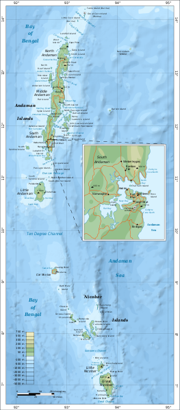
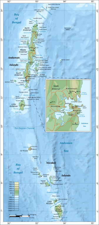
| موجودہ | ۲۱:۲۴, ۱۵ ستمبر ۲۰۱۰ | | ۹۰۶ × ۲,۰۶۰ (۶۲۱ کلوبائٹ) | Mysid | {{Information |Description={{en|1=Map of the Nicobar and Andaman Islands.}} |Source={{own}}. Self-made in Inkscape. Based on the 1976 CIA Indian Ocean Atlas (File:Andaman nicobar 76.jpg); bathymetry and topography from SRTM30_PLUS. |Author=[[w:User:M |
فائل دی ورتوں
تھلے دتے گئے 1 صفحے اس فائل نال جُڑدے نیں
فائل ویاپک ورتوں
ایہہ دوجے وکیاں ایس فائل نوں ورتدے نیں –
- af.wikipedia.org تے ورتوں
- ar.wikipedia.org تے ورتوں
- ast.wikipedia.org تے ورتوں
- az.wikipedia.org تے ورتوں
- be.wikipedia.org تے ورتوں
- br.wikipedia.org تے ورتوں
- ca.wikipedia.org تے ورتوں
- en.wikipedia.org تے ورتوں
- eo.wikipedia.org تے ورتوں
- es.wikipedia.org تے ورتوں
- fi.wikipedia.org تے ورتوں
- fi.wiktionary.org تے ورتوں
- fr.wikipedia.org تے ورتوں
- ga.wikipedia.org تے ورتوں
- gom.wikipedia.org تے ورتوں
- ha.wikipedia.org تے ورتوں
- hi.wikipedia.org تے ورتوں
- hi.wikibooks.org تے ورتوں
- hy.wikipedia.org تے ورتوں
- it.wikipedia.org تے ورتوں
- ja.wikipedia.org تے ورتوں
- mr.wikipedia.org تے ورتوں
- oc.wikipedia.org تے ورتوں
- pl.wikipedia.org تے ورتوں
- ru.wikipedia.org تے ورتوں
- sw.wikipedia.org تے ورتوں
- te.wikipedia.org تے ورتوں
- tg.wikipedia.org تے ورتوں
- uk.wikipedia.org تے ورتوں
- ur.wikipedia.org تے ورتوں
- www.wikidata.org تے ورتوں
- zh.wikipedia.org تے ورتوں