
فائل:NamTso scene.jpg

ایس وکھالے دا ناپ: ۸۰۰ × ۵۲۷ پکسلز۔ دوجے ریزولوشنز: ۳۲۰ × ۲۱۱ پکسلز | ۶۴۰ × ۴۲۲ پکسلز | ۹۹۹ × ۶۵۸ پکسلز ۔
اصل فائل (۹۹۹ × ۶۵۸ پکسلز, فائل حجم: ۶۱۱ کلوبائٹ, MIME type: image/jpeg)
خلاصہ
| تفصیل |
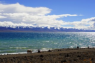
English: Nam Tso, Damxung County, Tibet |
| تریخ | |
| سروت | Flickr |
| لکھاری | Reurinkjan |
| Camera location | | View this and other nearby images on: OpenStreetMap |
|---|
لائسنس –
اے فائل ایس لائسنس تھلے آندی اے Creative Commons Attribution 1.0 Generic .
- تہانوں کھلھ اے:
- حصہ کرنا – کاپی، ونڈنا تے کم بھیجنا
- فیر رلانا – کم نوں فٹ کرنا
- تھلے دتیاں شرطاں نال:
- کس دے ناں – تسیں لازمی ایس کم دے بناں والے بارے دسو جنج اونے آکھیا اے یا جنج لسنس چ آکھیا گیا ہے۔
| This image was originally posted to Flickr by reurinkjan at https://www.flickr.com/photos/15470975@N03/2927698628. It was reviewed on ۹ ستمبر ۲۰۰۹ by FlickreviewR and was confirmed to be licensed under the terms of the cc-by-2.0. |
فائل دی تریخ
فائل نو اس ویلے دی حالت وچ ویکھن واسطے تاریخ/ویلے تے کلک کرو۔
| تریخ تے ویلہ | نکی مورت | پاسے | ورتن والا | تیپّݨی کرو | |
|---|---|---|---|---|---|
| موجودہ | ۲۳:۲۹, ۸ ستمبر ۲۰۰۹ | | ۹۹۹ × ۶۵۸ (۶۱۱ کلوبائٹ) | Himalayan Explorer | {{Information |Description={{en|1=g}} |Source=g |Author=g |Date=g |Permission= |other_versions= }} |
فائل دی ورتوں
تھلے دتے گئے 1 صفحے اس فائل نال جُڑدے نیں
فائل ویاپک ورتوں
ایہہ دوجے وکیاں ایس فائل نوں ورتدے نیں –
- ar.wikipedia.org تے ورتوں
- ast.wikipedia.org تے ورتوں
- bn.wikipedia.org تے ورتوں
- bo.wikipedia.org تے ورتوں
- ca.wikipedia.org تے ورتوں
- ceb.wikipedia.org تے ورتوں
- en.wikipedia.org تے ورتوں
- es.wikipedia.org تے ورتوں
- fa.wikipedia.org تے ورتوں
- hi.wikipedia.org تے ورتوں
- hr.wikipedia.org تے ورتوں
- incubator.wikimedia.org تے ورتوں
- it.wikipedia.org تے ورتوں
- ko.wikipedia.org تے ورتوں
- lt.wikipedia.org تے ورتوں
- lv.wikipedia.org تے ورتوں
- nl.wikipedia.org تے ورتوں
- nn.wikipedia.org تے ورتوں
- sl.wikipedia.org تے ورتوں
- sr.wikipedia.org تے ورتوں
- sv.wikipedia.org تے ورتوں
- te.wikipedia.org تے ورتوں
- tk.wikipedia.org تے ورتوں
- tr.wikipedia.org تے ورتوں
- ur.wikipedia.org تے ورتوں
- zh.wikipedia.org تے ورتوں