
فائل:Obcine Slovenija 2006.svg

Size of this PNG preview of this SVG file: ۸۰۰ × ۵۲۲ پکسلز. دوجے ریزولوشنز: ۳۲۰ × ۲۰۹ پکسلز | ۶۴۰ × ۴۱۸ پکسلز | ۱,۰۲۴ × ۶۶۸ پکسلز | ۱,۲۸۰ × ۸۳۵ پکسلز | ۲,۵۶۰ × ۱,۶۷۰ پکسلز | ۲,۶۱۳ × ۱,۷۰۵ پکسلز ۔
اصل فائل (ایس وی جی فائل، پکسل:۲,۶۱۳ × ۱,۷۰۵، فائل سائز: ۲.۳۱ میگابائٹ)
خلاصہ
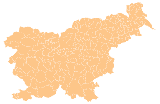
| تفصیل | Map of the municipalities (občine) of the Republic of Slovenia, as since May 2006 (210 units). |
| تریخ | |
| سروت | Source of the public data is GURS (Geodetska uprava Republike Slovenije or Surveying and Mapping Authority of the Republic of Slovenia). Converted from Shapefile to SVG with shp2svg and prepared for Wikipedia by romanm (talk). |
| لکھاری | See above. |
| اجازت (فائل نوں دوبارہ ورتنا) |
See Pogoji uporabe (in Slovene) and Terms and conditions (English). According to price list, which states cost 0€ for using free-of-charge published data on municipalities even for commercial purposes(!), I consider the data to be in public domain. I also hereby grant my work on this file to be in public domain. |
| دوجے ورژن |
|

لائسنس –
| میں، اس کم دے کاپیرائٹ دا مالک، اس کم نوں لوکاں واسطے دیندا واں۔ اے سارے جگ واسطے لاگو اے۔ کج ملکاں چ قانونی طور تے اے ممکن نئیں اے؛ اگر انج ای اے ے: میں ہر کسے نوں اس کم نوں کسے وی مقصد واسطے ورتن دا بغیر کسے شرط دے حق دیندا واں، اگر اوہ قانون دے خلاف نا ہوۓ۔ |
فائل دی تریخ
فائل نو اس ویلے دی حالت وچ ویکھن واسطے تاریخ/ویلے تے کلک کرو۔
| تریخ تے ویلہ | نکی مورت | پاسے | ورتن والا | تیپّݨی کرو | |
|---|---|---|---|---|---|
| موجودہ | ۲۱:۱۹, ۱۳ اپریل ۲۰۱۲ | | ۲,۶۱۳ × ۱,۷۰۵ (۲.۳۱ میگابائٹ) | Martin Kraft | size and display problem fixed reduced number of points |
| ۰۲:۳۲, ۴ نومبر ۲۰۰۸ |  | ۲,۶۱۳ × ۱,۷۰۵ (۲.۳۶ میگابائٹ) | Romanm | fixed aspect ratio Category:Maps of administrative units of Slovenia | |
| ۰۲:۲۱, ۴ نومبر ۲۰۰۸ |  | ۵۱۲ × ۳۳۴ (۲.۳۶ میگابائٹ) | Romanm | {{Information |Description=Map of the municipalities (''občine'') of the Republic of Slovenia, as since May 2006 (211 units). |Source=Source of [http://www.gu.gov.si/si/delovnapodrocja_gu/podatki_gu/brezplani_podatki/brezplani_podatki_obine/ the public d |
فائل دی ورتوں
اس فائل نال جڑیا کوئی صفحہ نئیں۔
فائل ویاپک ورتوں
ایہہ دوجے وکیاں ایس فائل نوں ورتدے نیں –
- ast.wikipedia.org تے ورتوں
- azb.wikipedia.org تے ورتوں
- cs.wikipedia.org تے ورتوں
- de.wikipedia.org تے ورتوں
- eu.wikipedia.org تے ورتوں
- kbd.wikipedia.org تے ورتوں
- la.wikipedia.org تے ورتوں
- sco.wikipedia.org تے ورتوں
- sl.wikipedia.org تے ورتوں
- vi.wikipedia.org تے ورتوں