
فائل:Okraoutput.png
ایس وکھالے دا ناپ: ۸۰۰ × ۴۸۰ پکسلز۔ دوجے ریزولوشنز: ۳۲۰ × ۱۹۲ پکسلز | ۱,۰۲۴ × ۶۱۴ پکسلز | ۱,۶۰۰ × ۹۶۰ پکسلز ۔
اصل فائل (۱,۶۰۰ × ۹۶۰ پکسلز, فائل حجم: ۴۳۰ کلوبائٹ, MIME type: image/png)
خلاصہ
| تفصیل |
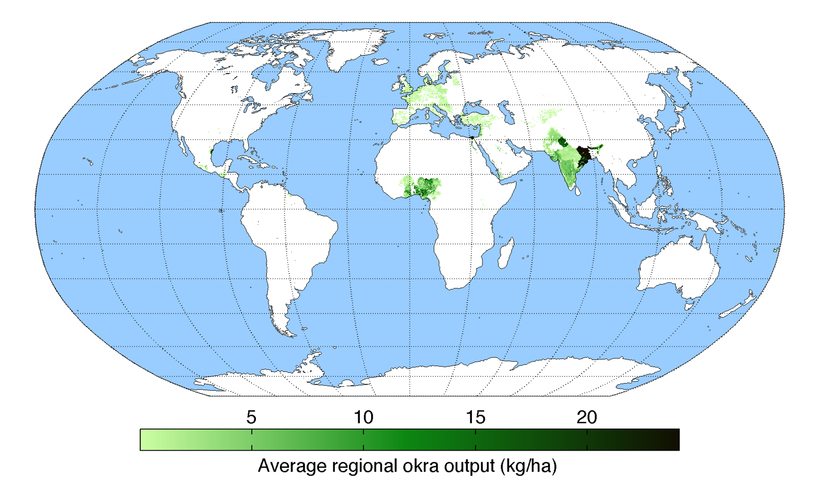
English: Map of okra production (average percentage of land used for its production times average yield in each grid cell) across the world compiled by the University of Minnesota Institute on the Environment with data from: Monfreda, C., N. Ramankutty, and J.A. Foley. 2008. Farming the planet: 2. Geographic distribution of crop areas, yields, physiological types, and net primary production in the year 2000. Global Biogeochemical Cycles 22: GB1022 |
| تریخ | |
| سروت | آپݨا کم |
| لکھاری | AndrewMT |
لائسنس –
میں، اس کم دے کاپیرائٹ دا مالک، اس کم نوں اس لائسنس دے مطابق چھاپدا واں:
ایس فائل نوں کریٹو کامنز Attribution 3.0 انپورٹڈ لائسنس دتا گیا.
- تہانوں کھلھ اے:
- حصہ کرنا – کاپی، ونڈنا تے کم بھیجنا
- فیر رلانا – کم نوں فٹ کرنا
- تھلے دتیاں شرطاں نال:
- کس دے ناں – تسیں لازمی ایس کم دے بناں والے بارے دسو جنج اونے آکھیا اے یا جنج لسنس چ آکھیا گیا ہے۔
فائل دی تریخ
فائل نو اس ویلے دی حالت وچ ویکھن واسطے تاریخ/ویلے تے کلک کرو۔
| تریخ تے ویلہ | نکی مورت | پاسے | ورتن والا | تیپّݨی کرو | |
|---|---|---|---|---|---|
| موجودہ | ۰۱:۳۰, ۲۰ مئی ۲۰۱۰ | | ۱,۶۰۰ × ۹۶۰ (۴۳۰ کلوبائٹ) | AndrewMT | {{Information |Description={{en|1=Map of okra production across the world compiled by the University of Minnesota Institute on the Environment with data from: Monfreda, C., N. Ramankutty, and J.A. Foley. 2008. Farming the planet: 2. Geographic distributio |
فائل دی ورتوں
تھلے دتے گئے 1 صفحے اس فائل نال جُڑدے نیں
فائل ویاپک ورتوں
ایہہ دوجے وکیاں ایس فائل نوں ورتدے نیں –
- ar.wikipedia.org تے ورتوں
- arz.wikipedia.org تے ورتوں
- ast.wikipedia.org تے ورتوں
- bcl.wikipedia.org تے ورتوں
- bg.wikipedia.org تے ورتوں
- bh.wikipedia.org تے ورتوں
- ca.wikipedia.org تے ورتوں
- cs.wikipedia.org تے ورتوں
- da.wikipedia.org تے ورتوں
- en.wiktionary.org تے ورتوں
- eu.wikipedia.org تے ورتوں
- gl.wikipedia.org تے ورتوں
- ha.wikipedia.org تے ورتوں
- he.wikipedia.org تے ورتوں
- hu.wikipedia.org تے ورتوں
- hy.wikipedia.org تے ورتوں
- ilo.wikipedia.org تے ورتوں
- is.wikipedia.org تے ورتوں
- ja.wikipedia.org تے ورتوں
- kn.wikipedia.org تے ورتوں
- mnw.wiktionary.org تے ورتوں
- nn.wikipedia.org تے ورتوں
- or.wikipedia.org تے ورتوں
- pa.wikipedia.org تے ورتوں
- pt.wikipedia.org تے ورتوں
- sd.wikipedia.org تے ورتوں
- simple.wikipedia.org تے ورتوں
- sl.wikipedia.org تے ورتوں
- sr.wikipedia.org تے ورتوں
- sv.wikipedia.org تے ورتوں
- th.wikipedia.org تے ورتوں
- tr.wikipedia.org تے ورتوں
- ur.wikipedia.org تے ورتوں
- www.wikidata.org تے ورتوں
- zh-yue.wikipedia.org تے ورتوں
- zh.wikipedia.org تے ورتوں