
فائل:Qing China 1820.png
ایس وکھالے دا ناپ: ۸۰۰ × ۵۹۳ پکسلز۔ دوجے ریزولوشنز: ۳۲۰ × ۲۳۷ پکسلز | ۶۴۰ × ۴۷۵ پکسلز | ۹۱۰ × ۶۷۵ پکسلز ۔
اصل فائل (۹۱۰ × ۶۷۵ پکسلز, فائل حجم: ۳۲۷ کلوبائٹ, MIME type: image/png)
| تفصیل |
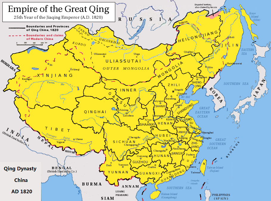
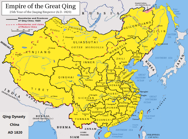
English: Map of the Qing Dynasty China in 1820. (Includes provincial boundaries and the boundaries of modern China for reference.) Adapted from http://en.wikipedia.org/wiki/Image:ROC_PRC_comparison_eng.jpg and information complied from other sources such as http://baike.baidu.com/view/5405.htm , http://map.huhai.net/58-59.jpg and http://www.sina7.com/jdwh/UploadFiles_6109/200709/20070918093610860.jpg 中文(简体):大清嘉庆二十五年疆域图。 中文(繁體):大清嘉慶廿五年疆域圖。 日本語: 大清の嘉慶25年の疆域の図。 Tiếng Việt: Đại Thanh bản đồ (1820). |
| تریخ | (UTC) |
| سروت |
|
| لکھاری |
|
| This is a retouched picture, which means that it has been digitally altered from its original version. Modifications: border islands. The original can be viewed here: Qing Dynasty 1820.png:
|
میں، اس کم دے کاپیرائٹ دا مالک، اس کم نوں اس لائسنس دے مطابق چھاپدا واں:
ایس فائل نوں کریٹو کامنز Attribution 2.5 پولینڈ لائسنس دتا گیا.
- تہانوں کھلھ اے:
- حصہ کرنا – کاپی، ونڈنا تے کم بھیجنا
- فیر رلانا – کم نوں فٹ کرنا
- تھلے دتیاں شرطاں نال:
- کس دے ناں – تسیں لازمی ایس کم دے بناں والے بارے دسو جنج اونے آکھیا اے یا جنج لسنس چ آکھیا گیا ہے۔
- اکو جہا شئیر کرو۔ – اگر تسیں بدلدے یا ایس کم تے بناندے تے بنن والے کم نوں اینج دے لسنس نال ای ونڈو گے۔

|
کاپی کرن، ونڈن تے بدلن دی ایس ڈوکومنٹ لئی اجازت دتی جاندی اے ایہناں GNU Free Documentation License, Version 1.2 شرطاں نال یا مگروں کسے وی چھپے ورین Free Software Foundation توں بنا کسے انویرینٹ سیکشن دے، ناں فرنٹ کور لکھت تے ناں بیک کور لکھت دے۔ لسنس دی اک کاپی سیکشن وچ ہیگی اے جہدا ناں اے GNU Free Documentation License۔ |
تسیں اپنی مرضی دا لائسنس چݨ سکدے اوہ۔
پہلا اپلوڈ دا ریکارڈ
This image is a derivative work of the following images:
- File:Qing_Dynasty_1820.png licensed with Cc-by-sa-3.0, GFDL
- 2010-06-22T03:48:22Z Benlisquare 910x675 (363965 Bytes) Revert - redraw the map yourself. MS Paint overlaying of a corner is an eyesore. Illogical to have the title repeated twice.
- 2010-06-21T21:46:33Z Hisacw 910x675 (395648 Bytes) rv to NPOVify: the status on certain outlier islands (e.g. Sakhalin) is not explicitly defined, c.f. the map [http://go-passport.grolier.com/map?id=mh00032&pid=go]
- 2010-06-20T05:59:11Z Benlisquare 910x675 (363965 Bytes) Reverted to version as of 19:58, 27 September 2008
- 2010-06-20T05:58:44Z Benlisquare 910x675 (363965 Bytes) possible POV vandal
- 2010-06-19T05:34:53Z Hisacw 910x675 (395648 Bytes) small adj from original
- 2008-10-15T02:32:20Z Pryaltonian 910x675 (363965 Bytes) Reverted to version as of 19:58, 27 September 2008
- 2008-10-15T02:29:27Z Pryaltonian 910x675 (400039 Bytes) [[Category:China]] [[Category:Taiwan]] [[Category:Tibet]] [[Category:Mongolia]]
- 2008-09-27T19:58:02Z Pryaltonian 910x675 (363965 Bytes) {{Information |Description={{en|1=Map of the Qing Dynasty at its greatest extent. Includes provincial boundaries and the boundaries of modern China for reference.}} |Source=Own work by uploader |Author=[[User:Pryaltonian|Pry
Uploaded with derivativeFX
فائل دی تریخ
فائل نو اس ویلے دی حالت وچ ویکھن واسطے تاریخ/ویلے تے کلک کرو۔
| تریخ تے ویلہ | نکی مورت | پاسے | ورتن والا | تیپّݨی کرو | |
|---|---|---|---|---|---|
| موجودہ | ۱۱:۰۲, ۲۳ فروری ۲۰۲۰ | | ۹۱۰ × ۶۷۵ (۳۲۷ کلوبائٹ) | Morrisonjohn022 | Reverted to version as of 17:00, 23 July 2011 (UTC) While the indigenous peoples of Sakhalin was not Han Chinese, Sakhalin was claimed by the Qing Empire and it was recognized as such by other countries (until the 1858 Treaty of Aigun and 1860 Treaty of Peking gave the island to Russia). See p. 11 of "Restless Empire: China and the World Since 1750" by Odd Arne Westad, p. 200 of "Ethnic Groups of North, East, and Central Asia: An Encyclopedia" by James B. Minahan, and p. 2 of "Across Forest,... |
| ۱۷:۳۵, ۲۶ اکتوبر ۲۰۱۹ |  | ۹۱۰ × ۶۷۵ (۳۸۶ کلوبائٹ) | Artanisen | Reverted to version as of 22:40, 24 October 2010 (UTC) Sakhalin was not Chinese. It was first occupied by the indigenous Ainu people and later it became half Japanese (Karafuto) and Russian (Sakhalin) then it became wholly part of the Russian Federation after WW2 | |
| ۲۲:۰۰, ۲۳ جولائی ۲۰۱۱ |  | ۹۱۰ × ۶۷۵ (۳۲۷ کلوبائٹ) | Shibo77 | .. | |
| ۰۳:۴۰, ۲۵ اکتوبر ۲۰۱۰ |  | ۹۱۰ × ۶۷۵ (۳۸۶ کلوبائٹ) | Wengier | minor | |
| ۰۳:۳۵, ۲۵ اکتوبر ۲۰۱۰ |  | ۹۱۰ × ۶۷۵ (۳۸۶ کلوبائٹ) | Wengier | {{Information |Description={{en|1=Map of the Qing Dynasty China in 1820. (Includes provincial boundaries and the boundaries of modern China for reference.)<br/>Adapted from http://en.wikipedia.org/wiki/Image:ROC_PRC_comparison_eng.jpg and information comp |
فائل دی ورتوں
تھلے دتے گئے 1 صفحے اس فائل نال جُڑدے نیں
فائل ویاپک ورتوں
ایہہ دوجے وکیاں ایس فائل نوں ورتدے نیں –
- bcl.wikipedia.org تے ورتوں
- be.wikipedia.org تے ورتوں
- bn.wikipedia.org تے ورتوں
- en.wikipedia.org تے ورتوں
- hi.wikipedia.org تے ورتوں
- ml.wikipedia.org تے ورتوں
- pl.wikipedia.org تے ورتوں
- ru.wikipedia.org تے ورتوں
- tl.wikipedia.org تے ورتوں
- ur.wikipedia.org تے ورتوں
- zh.wikipedia.org تے ورتوں