
فائل:Sahel Map-Africa rough.png
ایس وکھالے دا ناپ: ۸۰۰ × ۳۷۰ پکسلز۔ دوجے ریزولوشنز: ۳۲۰ × ۱۴۸ پکسلز | ۶۴۰ × ۲۹۶ پکسلز | ۱,۰۲۴ × ۴۷۴ پکسلز | ۲,۰۰۰ × ۹۲۵ پکسلز ۔
اصل فائل (۲,۰۰۰ × ۹۲۵ پکسلز, فائل حجم: ۲۹۱ کلوبائٹ, MIME type: image/png)
| تفصیل |
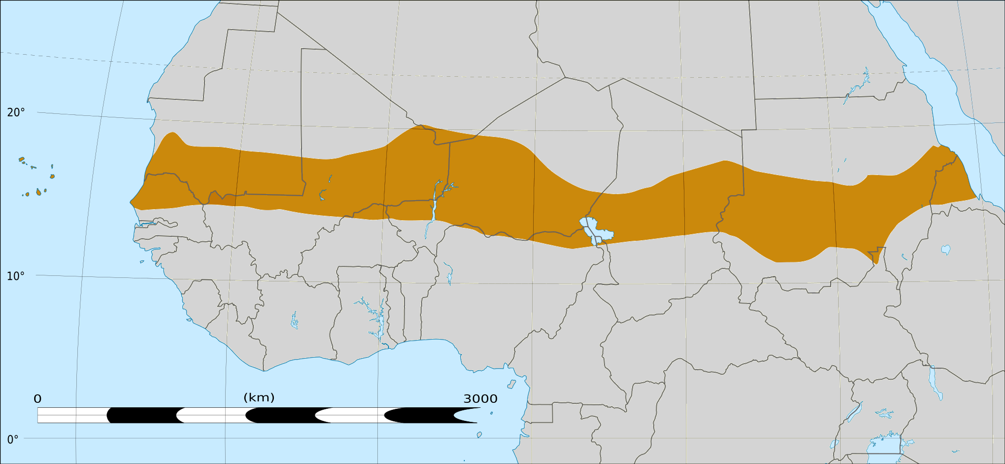
English: Map of Africa, with the Sahel highlighted in orange.
This is roughly the African land area between the lines of 200mm (north) and 600mm (south) mean 20th century annual rainfall. This is limited to land areas directly to the south of the Sahara desert and including the islands of Cape Verde, but not including other areas in Africa with the same rainfall statistics. This is one, but not the only, definition of the Sahel region. |
|||
| تریخ | ۲۰ فروری ۲۰۰۹ 03:54 (UTC) | |||
| سروت |
Felix Koenig: "created/photographed by myself (based on the existing blank map of Africa)"
|
|||
| لکھاری | ||||
| دوجے ورژن |
|


| This is a retouched picture, which means that it has been digitally altered from its original version. Modifications: Reproduced Sahel boundary from Map sahel.jpg on png map, cropped. The original can be viewed here: BlankMap-Africa2.png:
|
لائسنس –
میں، اس کم دے کاپیرائٹ دا مالک، اس کم نوں اس لائسنس دے مطابق چھاپدا واں:

|
کاپی کرن، ونڈن تے بدلن دی ایس ڈوکومنٹ لئی اجازت دتی جاندی اے ایہناں GNU Free Documentation License, Version 1.2 شرطاں نال یا مگروں کسے وی چھپے ورین Free Software Foundation توں بنا کسے انویرینٹ سیکشن دے، ناں فرنٹ کور لکھت تے ناں بیک کور لکھت دے۔ لسنس دی اک کاپی سیکشن وچ ہیگی اے جہدا ناں اے GNU Free Documentation License۔ |
This file is licensed under the Creative Commons Attribution-Share Alike Attribution-Share Alike 4.0 International, 3.0 Unported, 2.5 Generic, 2.0 Generic and 1.0 Generic license.
- تہانوں کھلھ اے:
- حصہ کرنا – کاپی، ونڈنا تے کم بھیجنا
- فیر رلانا – کم نوں فٹ کرنا
- تھلے دتیاں شرطاں نال:
- کس دے ناں – تسیں لازمی ایس کم دے بناں والے بارے دسو جنج اونے آکھیا اے یا جنج لسنس چ آکھیا گیا ہے۔
- اکو جہا شئیر کرو۔ – اگر تسیں بدلدے یا ایس کم تے بناندے تے بنن والے کم نوں اینج دے لسنس نال ای ونڈو گے۔
تسیں اپنی مرضی دا لائسنس چݨ سکدے اوہ۔
|
|
کاپی کرن، ونڈن تے بدلن دی ایس ڈوکومنٹ لئی اجازت دتی جاندی اے ایہناں GNU Free Documentation License, Version 1.2 شرطاں نال یا مگروں کسے وی چھپے ورین Free Software Foundation توں بنا کسے انویرینٹ سیکشن دے، ناں فرنٹ کور لکھت تے ناں بیک کور لکھت دے۔ لسنس دی اک کاپی سیکشن وچ ہیگی اے جہدا ناں اے GNU Free Documentation License۔ |
پہلا اپلوڈ دا ریکارڈ
This image is a derivative work of the following images:
- File:Map_sahel.jpg licensed with GFDL
- 2005-05-30T17:36:46Z King 800x800 (89588 Bytes) one moment please
- File:BlankMap-Africa2.png licensed with Cc-by-sa-3.0,2.5,2.0,1.0, GFDL
- 2008-03-08T18:02:20Z Sadalmelik 1754x1546 (51013 Bytes) {{Information |Description=Blank map of Africa |Source=self-made |Date=2008-03-08 |Author= [[User:Sadalmelik|Sadalmelik]] |Permission= |other_versions= }} [[Category:Blank maps of Africa]]
Uploaded with derivativeFX
فائل دی تریخ
فائل نو اس ویلے دی حالت وچ ویکھن واسطے تاریخ/ویلے تے کلک کرو۔
| تریخ تے ویلہ | نکی مورت | پاسے | ورتن والا | تیپّݨی کرو | |
|---|---|---|---|---|---|
| موجودہ | ۲۱:۱۵, ۱۷ مارچ ۲۰۱۸ | | ۲,۰۰۰ × ۹۲۵ (۲۹۱ کلوبائٹ) | Maphobbyist | South Sudan border |
| ۰۹:۰۲, ۲۰ فروری ۲۰۰۹ |  | ۱,۳۸۴ × ۶۵۸ (۲۹ کلوبائٹ) | T L Miles | {{Information |Description=*Description: A map of Africa: the Sahel highlighted in orange. Note, this is ROUGHLY the African land area between the lines of 200mm (north) and 600mm (south) mean 20th century annual rainfall. This is limited to land areas d |
فائل دی ورتوں
تھلے دتے گئے 1 صفحے اس فائل نال جُڑدے نیں
فائل ویاپک ورتوں
ایہہ دوجے وکیاں ایس فائل نوں ورتدے نیں –
- af.wikipedia.org تے ورتوں
- als.wikipedia.org تے ورتوں
- ar.wikipedia.org تے ورتوں
- az.wikipedia.org تے ورتوں
- bcl.wikipedia.org تے ورتوں
- be.wikipedia.org تے ورتوں
- bg.wikipedia.org تے ورتوں
- bn.wikipedia.org تے ورتوں
- br.wikipedia.org تے ورتوں
- ca.wikipedia.org تے ورتوں
- ce.wikipedia.org تے ورتوں
- da.wikipedia.org تے ورتوں
- en.wikipedia.org تے ورتوں
- eu.wikipedia.org تے ورتوں
- fa.wikipedia.org تے ورتوں
- fi.wiktionary.org تے ورتوں
- fr.wikipedia.org تے ورتوں
- fr.wikinews.org تے ورتوں
- ha.wikipedia.org تے ورتوں
- ig.wikipedia.org تے ورتوں
- incubator.wikimedia.org تے ورتوں
- it.wikipedia.org تے ورتوں
- ja.wikipedia.org تے ورتوں
- ka.wikipedia.org تے ورتوں
- ko.wikipedia.org تے ورتوں
- mg.wikipedia.org تے ورتوں
- mk.wikipedia.org تے ورتوں
ایس فائل دا ویکھو ہور جگت ورتن .