
فائل:Sinai-peninsula-map.jpg

ایس وکھالے دا ناپ: ۴۸۳ × ۶۰۰ پکسلز۔ دوجے ریزولوشنز: ۱۹۳ × ۲۴۰ پکسلز | ۳۸۷ × ۴۸۰ پکسلز | ۹۴۱ × ۱,۱۶۸ پکسلز ۔
اصل فائل (۹۴۱ × ۱,۱۶۸ پکسلز, فائل حجم: ۶۶۵ کلوبائٹ, MIME type: image/jpeg)
فلسطين
خلاصہ
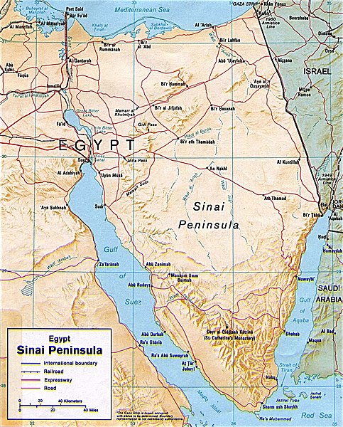
| تفصیل | Shaded relief map of the Sinai Peninsula, 1992, produced by the U.S. Central Intelligence Agency. |
| تریخ | |
| سروت | University of Texas Libraries, Perry-Castañeda Library Map Collection: Egypt Maps |
| لکھاری | CIA |
| دوجے ورژن |
|


لائسنس –
| This image is a work of a Central Intelligence Agency employee, taken or made as part of that person's official duties. As a Work of the United States Government, this image or media is in the public domain in the United States.
|

|
فائل دی تریخ
فائل نو اس ویلے دی حالت وچ ویکھن واسطے تاریخ/ویلے تے کلک کرو۔
| تریخ تے ویلہ | نکی مورت | پاسے | ورتن والا | تیپّݨی کرو | |
|---|---|---|---|---|---|
| موجودہ | ۰۱:۴۵, ۱۳ مئی ۲۰۱۱ | | ۹۴۱ × ۱,۱۶۸ (۶۶۵ کلوبائٹ) | Ras67 | cropped |
| ۰۳:۵۸, ۵ مارچ ۲۰۰۷ |  | ۹۵۶ × ۱,۱۹۶ (۳۰۷ کلوبائٹ) | Joao Xavier | Map of the Sinai Peninsula. (U.S. Central Intelligence Agency, https://www.cia.gov/cia/publications/mapspub/index.shtml) originally found on University of Texas library website (http://www.lib.utexas.edu/maps/middle_east_and_asia/sinai.jpg) and claimed as |
فائل دی ورتوں
تھلے دتے گئے 1 صفحے اس فائل نال جُڑدے نیں
فائل ویاپک ورتوں
ایہہ دوجے وکیاں ایس فائل نوں ورتدے نیں –
- af.wikipedia.org تے ورتوں
- als.wikipedia.org تے ورتوں
- ar.wikipedia.org تے ورتوں
- ast.wikipedia.org تے ورتوں
- azb.wikipedia.org تے ورتوں
- az.wikipedia.org تے ورتوں
- az.wiktionary.org تے ورتوں
- ba.wikipedia.org تے ورتوں
- bn.wikipedia.org تے ورتوں
- bs.wikipedia.org تے ورتوں
- ca.wikipedia.org تے ورتوں
- cs.wikipedia.org تے ورتوں
- da.wikipedia.org تے ورتوں
- de.wikipedia.org تے ورتوں
- de.wikinews.org تے ورتوں
- de.wiktionary.org تے ورتوں
- diq.wikipedia.org تے ورتوں
- el.wikipedia.org تے ورتوں
- el.wiktionary.org تے ورتوں
- en.wikipedia.org تے ورتوں
- eo.wikipedia.org تے ورتوں
- es.wikipedia.org تے ورتوں
- eu.wikipedia.org تے ورتوں
ایس فائل دا ویکھو ہور جگت ورتن .