
فائل:Southeast Europe 1812 map en.PNG

ایس وکھالے دا ناپ: ۶۳۰ × ۵۹۹ پکسلز۔ دوجے ریزولوشنز: ۲۵۲ × ۲۴۰ پکسلز | ۵۰۵ × ۴۸۰ پکسلز | ۸۰۸ × ۷۶۸ پکسلز | ۱,۲۰۳ × ۱,۱۴۴ پکسلز ۔
اصل فائل (۱,۲۰۳ × ۱,۱۴۴ پکسلز, فائل حجم: ۶۲۳ کلوبائٹ, MIME type: image/png)
خلاصہ
| تفصیل |
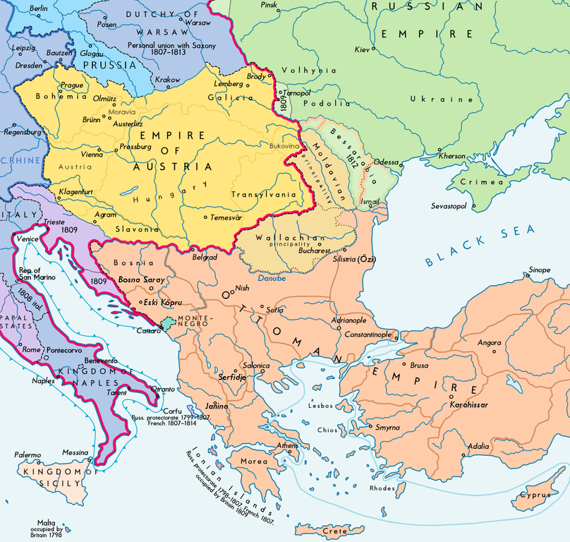
Español: Sudeste europeo en 1812 (antes de la invasión napoleónica de Rusia) English: Southeast Europe in 1812 (before Napoleon's Russian Campaign ; according with H.E.Stier (dir.) Grosser Atlas zur Weltgeschichte, Westermann 1984, p.119, ISBN 3141009198, & all sources, the Danubian principalities were not Turkish provinces but vassal Christian states (ruled by Greek hospodars), and the Russian Bessarabia were, before 1812, a part of the Moldavian principality (north side) and of the Ottoman Empire (south side) : see little changes 02-05-2014) |
| تریخ | |
| سروت | Wikimedia Commons |
| لکھاری |
|
| اجازت (فائل نوں دوبارہ ورتنا) |

| This is a retouched picture, which means that it has been digitally altered from its original version. Modifications: extracted and minor changes. The original can be viewed here: Europe 1812 map en.png:
|
لائسنس –
میں، اس کم دے کاپیرائٹ دا مالک، اس کم نوں اس لائسنس دے مطابق چھاپدا واں:
ایس فائل نوں کریٹو کامنز Attribution 2.5 پولینڈ لائسنس دتا گیا.
- تہانوں کھلھ اے:
- حصہ کرنا – کاپی، ونڈنا تے کم بھیجنا
- فیر رلانا – کم نوں فٹ کرنا
- تھلے دتیاں شرطاں نال:
- کس دے ناں – تسیں لازمی ایس کم دے بناں والے بارے دسو جنج اونے آکھیا اے یا جنج لسنس چ آکھیا گیا ہے۔
- اکو جہا شئیر کرو۔ – اگر تسیں بدلدے یا ایس کم تے بناندے تے بنن والے کم نوں اینج دے لسنس نال ای ونڈو گے۔
فائل دی تریخ
فائل نو اس ویلے دی حالت وچ ویکھن واسطے تاریخ/ویلے تے کلک کرو۔
| تریخ تے ویلہ | نکی مورت | پاسے | ورتن والا | تیپّݨی کرو | |
|---|---|---|---|---|---|
| موجودہ | ۲۳:۲۲, ۱۳ ستمبر ۲۰۱۷ | | ۱,۲۰۳ × ۱,۱۴۴ (۶۲۳ کلوبائٹ) | Trecătorul răcit | Lands of Austrian Empire |
| ۱۶:۱۰, ۳۱ مئی ۲۰۱۷ |  | ۱,۲۰۳ × ۱,۱۴۴ (۶۰۷ کلوبائٹ) | Trecătorul răcit | Border at Neretva mouths, pachaliks, Karahissar, Serfidje, raya of Hotin. | |
| ۲۲:۲۲, ۲ مئی ۲۰۱۴ |  | ۱,۲۰۳ × ۱,۱۴۴ (۵۴۶ کلوبائٹ) | Spiridon Ion Cepleanu | According with H.E.Stier (dir.) Grosser Atlas zur Weltgeschichte, Westermann 1984, p.119, ISBN 3141009198, & all sources, the Danubian principalities were not turkish provinces but vassal christian states (ruled by Greek hospodars), and the russian Bes... | |
| ۱۷:۰۵, ۲۱ دسمبر ۲۰۱۲ |  | ۱,۲۰۳ × ۱,۱۴۴ (۴۴۱ کلوبائٹ) | Durero | User created page with UploadWizard |
فائل دی ورتوں
تھلے دتے گئے 1 صفحے اس فائل نال جُڑدے نیں
فائل ویاپک ورتوں
ایہہ دوجے وکیاں ایس فائل نوں ورتدے نیں –
- bs.wikipedia.org تے ورتوں
- ca.wikipedia.org تے ورتوں
- cs.wikipedia.org تے ورتوں
- da.wikipedia.org تے ورتوں
- en.wikipedia.org تے ورتوں
- es.wikipedia.org تے ورتوں
- fa.wikipedia.org تے ورتوں
- fr.wikipedia.org تے ورتوں
- ga.wikipedia.org تے ورتوں
- hr.wikipedia.org تے ورتوں
- hu.wikipedia.org تے ورتوں
- hy.wikipedia.org تے ورتوں
- id.wikipedia.org تے ورتوں
- it.wikipedia.org تے ورتوں
- ja.wikipedia.org تے ورتوں
- ka.wikipedia.org تے ورتوں
- mk.wikipedia.org تے ورتوں
- pl.wikipedia.org تے ورتوں
- pt.wikipedia.org تے ورتوں
- ro.wikipedia.org تے ورتوں
- sh.wikipedia.org تے ورتوں
- sl.wikipedia.org تے ورتوں
- sr.wikipedia.org تے ورتوں
- tt.wikipedia.org تے ورتوں
- uk.wikipedia.org تے ورتوں
- ur.wikipedia.org تے ورتوں
- vi.wikipedia.org تے ورتوں
- zh.wikipedia.org تے ورتوں