
فائل:Sub-Saharan Africa definition UN.png
اس توں وڈی مورت موجود نہیں۔
Sub-Saharan_Africa_definition_UN.png (۳۶۲ × ۳۴۰ پکسلز, فائل حجم: ۶ کلوبائٹ, MIME type: image/png)

|
This map image could be re-created using vector graphics as an SVG file. This has several advantages; see Commons:Media for cleanup for more information. If an SVG form of this image is available, please upload it and afterwards replace this template with
{{vector version available|new image name}}.
It is recommended to name the SVG file “Sub-Saharan Africa definition UN.svg”—then the template Vector version available (or Vva) does not need the new image name parameter. |
| تفصیل |
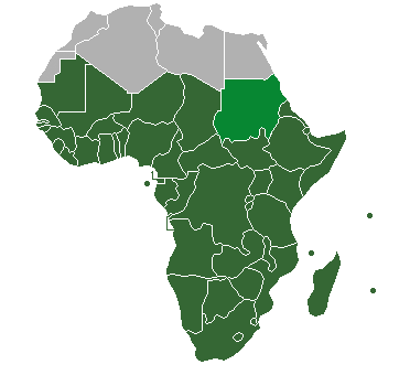
Definition of "Sub-Saharan Africa" as used in the statistics of many the UN institutions. Sudan is also classified as North Africa by the United Nations. |
| تریخ | (UTC) |
| سروت | |
| لکھاری |
| This is a retouched picture, which means that it has been digitally altered from its original version. Modifications: binary colouring of countries. The original can be viewed here: HDImap spectrum2006 Africa.png:
|
میں، اس کم دے کاپیرائٹ دا مالک، اس کم نوں اس لائسنس دے مطابق چھاپدا واں:
| میں، اس کم دے کاپیرائٹ دا مالک، اس کم نوں لوکاں واسطے دیندا واں۔ اے سارے جگ واسطے لاگو اے۔ کج ملکاں چ قانونی طور تے اے ممکن نئیں اے؛ اگر انج ای اے ے: میں ہر کسے نوں اس کم نوں کسے وی مقصد واسطے ورتن دا بغیر کسے شرط دے حق دیندا واں، اگر اوہ قانون دے خلاف نا ہوۓ۔ |
پہلا اپلوڈ دا ریکارڈ
This image is a derivative work of the following images:
- File:HDImap_spectrum2006_Africa.png licensed with PD-self
- 2007-03-09T10:43:40Z Dbachmann 356x344 (7521 Bytes) == Summary == Detail of [[:Image:HDImap spectrum2006.png]]. [[:en:United Natiows|UN]] [[:en:Human Development Index|Human Development Index (HDI)]] for 2004, derived from 2006 UN HDI report. An HDI below 0.5 is considered to
Uploaded with derivativeFX
فائل دی تریخ
فائل نو اس ویلے دی حالت وچ ویکھن واسطے تاریخ/ویلے تے کلک کرو۔
| تریخ تے ویلہ | نکی مورت | پاسے | ورتن والا | تیپّݨی کرو | |
|---|---|---|---|---|---|
| موجودہ | ۰۱:۴۷, ۲۰ جولائی ۲۰۱۳ | | ۳۶۲ × ۳۴۰ (۶ کلوبائٹ) | Maproom | Reshaded South Sudan, which the UN now regards as in East Africa, not North Africa: see http://unstats.un.org/unsd/methods/m49/m49regin.htm |
| ۱۸:۲۷, ۱۲ اپریل ۲۰۱۲ |  | ۳۶۲ × ۳۴۰ (۹ کلوبائٹ) | Hazhk | Adding different shading for Sudan & S. Sudan because they're also classified as being part of North Africa by the UN | |
| ۰۳:۰۲, ۱۰ جولائی ۲۰۱۱ |  | ۳۵۶ × ۳۴۴ (۱۱ کلوبائٹ) | Maphobbyist | South Sudan has become independent on July 9, 2011. Sudan and South Sudan are shown with the new international border between them. | |
| ۱۱:۴۶, ۳۱ مارچ ۲۰۱۱ |  | ۳۵۶ × ۳۴۴ (۱۰ کلوبائٹ) | Hoshie | added Cabinda (Angola) to map | |
| ۱۶:۱۸, ۱۵ دسمبر ۲۰۱۰ |  | ۳۵۶ × ۳۴۴ (۶ کلوبائٹ) | Jcherlet | {{Information |Description=Definition of Sub-Saharan Africa, according to the United Nations institutions |Source=*File:HDImap_spectrum2006_Africa.png |Date=2010-12-15 11:13 (UTC) |Author=*Jcherlet: '''Jcherlet''' *derivative work: |
فائل دی ورتوں
تھلے دتے گئے 1 صفحے اس فائل نال جُڑدے نیں
فائل ویاپک ورتوں
ایہہ دوجے وکیاں ایس فائل نوں ورتدے نیں –
- ast.wikipedia.org تے ورتوں
- ca.wikipedia.org تے ورتوں
- ckb.wikipedia.org تے ورتوں
- cs.wikipedia.org تے ورتوں
- de.wikipedia.org تے ورتوں
- en.wikipedia.org تے ورتوں
- Sub-Saharan Africa
- Water supply and sanitation in sub-Saharan Africa
- Wikipedia:Reference desk/Archives/Humanities/2013 October 5
- Category:Birds of Sub-Saharan Africa
- Category:Fauna of Sub-Saharan Africa
- Category:Biota of Sub-Saharan Africa
- Category:Mammals of Sub-Saharan Africa
- User:DexDor/Categorization of organisms by geography
- Category:Moths of Sub-Saharan Africa
- Category:Amphibians of Sub-Saharan Africa
- et.wikipedia.org تے ورتوں
- ha.wikipedia.org تے ورتوں
- he.wikipedia.org تے ورتوں
- id.wikipedia.org تے ورتوں
- ig.wikipedia.org تے ورتوں
- ilo.wikipedia.org تے ورتوں
- it.wikipedia.org تے ورتوں
- ja.wikipedia.org تے ورتوں
- ka.wikipedia.org تے ورتوں
- ko.wikipedia.org تے ورتوں
- lt.wikipedia.org تے ورتوں
- pa.wikipedia.org تے ورتوں
- ro.wikipedia.org تے ورتوں
- simple.wikipedia.org تے ورتوں
- sr.wikipedia.org تے ورتوں
- sv.wikipedia.org تے ورتوں
- ta.wikipedia.org تے ورتوں
- th.wikipedia.org تے ورتوں
- tn.wikipedia.org تے ورتوں
- tr.wikipedia.org تے ورتوں
- ur.wikipedia.org تے ورتوں
ایس فائل دا ویکھو ہور جگت ورتن .