
فائل:Wfm area 51 landsat geocover 2000.jpg
ایس وکھالے دا ناپ: ۴۷۵ × ۵۹۹ پکسلز۔ دوجے ریزولوشنز: ۱۹۰ × ۲۴۰ پکسلز | ۳۸۱ × ۴۸۰ پکسلز | ۷۵۲ × ۹۴۸ پکسلز ۔
اصل فائل (۷۵۲ × ۹۴۸ پکسلز, فائل حجم: ۳۸۳ کلوبائٹ, MIME type: image/jpeg)
| تفصیل |
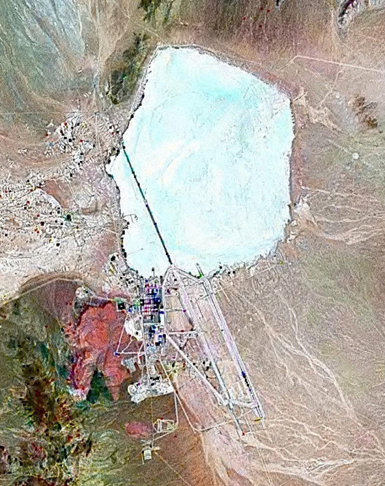
English: Landsat GeoCover 2000 pseudocolour imagery of Area 51 at Groom Lake, Nevada Test and Training Range, Nevada, USA
|
||||
| تریخ | circa ۲۰۰۰ | ||||
| سروت | NASA Landsat | ||||
| لکھاری | NASA | ||||
| اجازت (فائل نوں دوبارہ ورتنا) |
|

فائل دی تریخ
فائل نو اس ویلے دی حالت وچ ویکھن واسطے تاریخ/ویلے تے کلک کرو۔
| تریخ تے ویلہ | نکی مورت | پاسے | ورتن والا | تیپّݨی کرو | |
|---|---|---|---|---|---|
| موجودہ | ۱۷:۴۲, ۱۸ فروری ۲۰۱۰ | | ۷۵۲ × ۹۴۸ (۳۸۳ کلوبائٹ) | Finlay McWalter | rv, that's not a landsat image; it looks very much like a copyright GeoEye/Google Earth image, which is inelligible for use on Commons. If you diagree, upload the image under another name, don't contaminate this one with false information |
| ۱۶:۰۵, ۷ فروری ۲۰۱۰ |  | ۴۵۶ × ۶۱۷ (۴۵ کلوبائٹ) | Vajotwo | Best quality | |
| ۱۷:۵۱, ۱۶ جولائی ۲۰۰۶ |  | ۷۵۲ × ۹۴۸ (۳۸۳ کلوبائٹ) | Finlay McWalter | {{Information |Description=Landsat geocover 2000 pseudocolour imagery of Area 51 at Groom Lake, Nevada, USA |Source=NASA Landsat |Date=around 2000 |Author=NASA |Permission= {{PD-WorldWind}} |other_versions= }} Category:Area 51 |
فائل دی ورتوں
تھلے دتے گئے 1 صفحے اس فائل نال جُڑدے نیں
فائل ویاپک ورتوں
ایہہ دوجے وکیاں ایس فائل نوں ورتدے نیں –
- ar.wikipedia.org تے ورتوں
- az.wikipedia.org تے ورتوں
- be.wikipedia.org تے ورتوں
- bg.wikipedia.org تے ورتوں
- bn.wikipedia.org تے ورتوں
- cs.wikipedia.org تے ورتوں
- cy.wikipedia.org تے ورتوں
- el.wikipedia.org تے ورتوں
- en.wikipedia.org تے ورتوں
- es.wikipedia.org تے ورتوں
- fi.wikipedia.org تے ورتوں
- fr.wikipedia.org تے ورتوں
- Zone 51
- Wikipédia:Le Bistro/14 février 2009
- Area 51 (jeu vidéo, 2005)
- Wikipédia:Wikimag/2019/28/Rapport de trafic
- Wikipédia:Wikimag/2019/29/Rapport de trafic
- Wikipédia:Wikimag/2019/29
- Wikipédia:Wikimag/2019/30/Rapport de trafic
- Wikipédia:Wikimag/2019/31/Rapport de trafic
- Wikipédia:Wikimag/2019/38
- Wikipédia:Wikimag/2019/39/Rapport de trafic
- gu.wikipedia.org تے ورتوں
- he.wikipedia.org تے ورتوں
- hi.wikipedia.org تے ورتوں
- hr.wikipedia.org تے ورتوں
- hu.wikipedia.org تے ورتوں
- hy.wikipedia.org تے ورتوں
- id.wikipedia.org تے ورتوں
- it.wikipedia.org تے ورتوں
- kk.wikipedia.org تے ورتوں
- kn.wikipedia.org تے ورتوں
- mk.wikipedia.org تے ورتوں
- my.wikipedia.org تے ورتوں
- ro.wikipedia.org تے ورتوں
- ru.wikipedia.org تے ورتوں
- sh.wikipedia.org تے ورتوں
- si.wikipedia.org تے ورتوں
- sk.wikipedia.org تے ورتوں
ایس فائل دا ویکھو ہور جگت ورتن .