
فائل:Arabian Peninsula dust SeaWiFS.jpg

ایس وکھالے دا ناپ: ۶۵۷ × ۶۰۰ پکسلز۔ دوجے ریزولوشنز: ۲۶۳ × ۲۴۰ پکسلز | ۵۲۶ × ۴۸۰ پکسلز | ۸۴۱ × ۷۶۸ پکسلز | ۱,۱۲۲ × ۱,۰۲۴ پکسلز | ۲,۵۰۴ × ۲,۲۸۶ پکسلز ۔
اصل فائل (۲,۵۰۴ × ۲,۲۸۶ پکسلز, فائل حجم: ۸۵۳ کلوبائٹ, MIME type: image/jpeg)
| تفصیل |
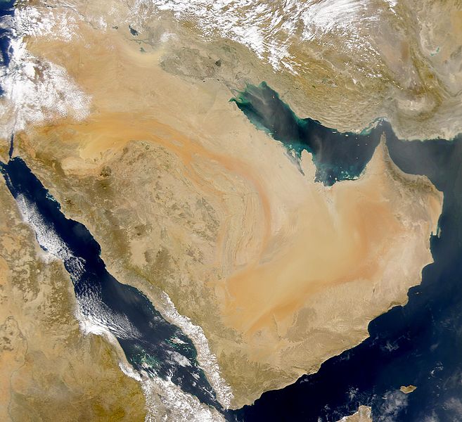
English: SeaWiFS collected this view of Arabia and of dust blowing across the Persian Gulf.
Español: La Península Arábiga vista desde el espacio |
| تریخ | Taken on ۲ مارچ ۲۰۰۰ |
| سروت | http://visibleearth.nasa.gov/view_rec.php?id=898 |
| لکھاری | SeaWiFS Project, NASA/Goddard Space Flight Center, and ORBIMAGE |
| دوجے ورژن |
Derivative works of this file: |
| This image is from the Sea-viewing Wide Field-of-view Sensor (SeaWiFS) Project and more than 5 years old.
Satellite data captured by the SeaWIFS sensor are released into the public domain 5 years after capture. Data less than five years old can be re-used only for educational or scientific purposes; any commercial use of such images must be coordinated with GeoEye. [1] |
| This work has been released into the public domain by its copyright holder, GeoEye. This applies worldwide. کج ملکاں چ قانونی طور تے اے ممکن نئیں اے؛ اگر انج ای اے ے: GeoEye ہر کسے نوں اس کم نوں کسے وی مقصد واسطے ورتن دا بغیر کسے شرط دے حق دیندا واں، اگر اوہ قانون دے خلاف نا ہوۓ۔
|
پہلا اپلوڈ دا ریکارڈ
The original description page was here. All following user names refer to commons.wikimedia.
- 2007-12-17 19:34 Hautala 2,504×2,286 (853000 bytes) {{PD-USGov-NASA}} Taken from NASA's Visible Earth, http://visibleearth.nasa.gov/
فائل دی تریخ
فائل نو اس ویلے دی حالت وچ ویکھن واسطے تاریخ/ویلے تے کلک کرو۔
| تریخ تے ویلہ | نکی مورت | پاسے | ورتن والا | تیپّݨی کرو | |
|---|---|---|---|---|---|
| موجودہ | ۲۲:۰۲, ۲ جنوری ۲۰۰۸ | | ۲,۵۰۴ × ۲,۲۸۶ (۸۵۳ کلوبائٹ) | Hautala | {{PD-USGov-NASA}} * {{en|Satellite image of Arabian peninsula}} * {{es|La Península Arábiga vista desde el espacio}} * {{en|Satelliittikuva Arabian niemimaasta}} Taken from NASA's [http://visibleearth.nasa.gov/ Visible Earth], from the page [http://v |
فائل دی ورتوں
تھلے دتے گئے 1 صفحے اس فائل نال جُڑدے نیں
فائل ویاپک ورتوں
ایہہ دوجے وکیاں ایس فائل نوں ورتدے نیں –
- af.wikipedia.org تے ورتوں
- als.wikipedia.org تے ورتوں
- arc.wikipedia.org تے ورتوں
- ar.wikipedia.org تے ورتوں
- سلطنة عمان
- اليمن
- قطر
- الكويت
- البحرين
- تاريخ السعودية
- شبه الجزيرة العربية
- تاريخ البحرين
- تاريخ اليمن
- تاريخ الكويت
- يهود اليمن
- ويكيبيديا:صناديق المستخدم/تاريخ
- قالب:تاريخ شبه الجزيرة العربية
- بوابة:الكويت
- تاريخ الإمارات العربية المتحدة
- مستخدم:Ali alomary
- بنو قينقاع
- تاريخ اليمن القديم
- بنو قريظة
- تاريخ قطر
- السعودية
- خط زمني لتاريخ اليمن
- تاريخ اليمن الحديث
- تاريخ اليمن الإسلامي
- مستخدم:SHOBAR
- الإمارات العربية المتحدة
- قالب:شبه الجزيرة العربية
- بنو النضير
- بوابة:البحرين
- بوابة:البحرين/قوالب
- مستخدم:Sayom
- مستخدم:سلمان القحطاني
- مستخدم:Ramses Nagib
- مستخدم:Aabuhaimed
- جيولوجيا السعودية
- يهود حبان
- يهود حضرموت
- مستخدم:Marco 2 en
- مستخدم:((55الغيثي55))/ملعب
- مستخدم:((55الغيثي55))
- بوابة:الكويت/قوالب
- مستخدم:مخنف
- مستخدم:Nedz3r
- مستخدم:Ikhlas Qassmi 13336
- مستخدم:بو خالد الجش
ایس فائل دا ویکھو ہور جگت ورتن .