
فائل:Bangladesh LOC 1996 map.jpg

ایس وکھالے دا ناپ: ۴۷۸ × ۵۹۹ پکسلز۔ دوجے ریزولوشنز: ۱۹۱ × ۲۴۰ پکسلز | ۳۸۳ × ۴۸۰ پکسلز | ۶۱۳ × ۷۶۸ پکسلز | ۸۱۷ × ۱,۰۲۴ پکسلز | ۱,۵۹۶ × ۲,۰۰۰ پکسلز ۔
اصل فائل (۱,۵۹۶ × ۲,۰۰۰ پکسلز, فائل حجم: ۱.۵ میگابائٹ, MIME type: image/jpeg)
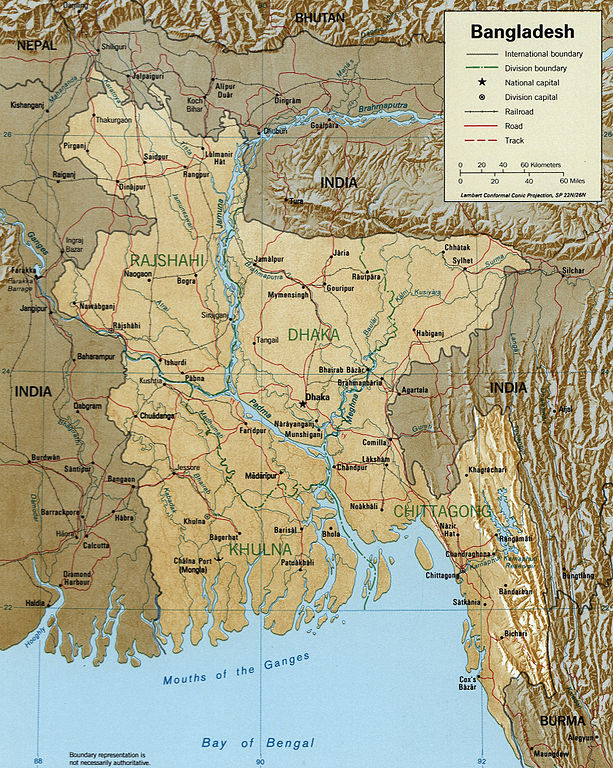
Map of Bangladesh.
http://hdl.loc.gov/loc.gmd/g7645.ct001002
This work is in the public domain in the United States because it is a work prepared by an officer or employee of the United States Government as part of that person’s official duties under the terms of Title 17, Chapter 1, Section 105 of the US Code.
Note: This only applies to original works of the Federal Government and not to the work of any individual U.S. state, territory, commonwealth, county, municipality, or any other subdivision. This template also does not apply to postage stamp designs published by the United States Postal Service since 1978. (See § 313.6(C)(1) of Compendium of U.S. Copyright Office Practices). It also does not apply to certain US coins; see The US Mint Terms of Use.
|
 | |
| ایہ فائل دے بارے چ دس اے جے اے کاپی حف دیاں روکاں توں کھلی اے تے نالدے رلدے حقاں توں وی۔ | ||
فائل دی تریخ
فائل نو اس ویلے دی حالت وچ ویکھن واسطے تاریخ/ویلے تے کلک کرو۔
| تریخ تے ویلہ | نکی مورت | پاسے | ورتن والا | تیپّݨی کرو | |
|---|---|---|---|---|---|
| موجودہ | ۰۰:۵۶, ۲۶ اکتوبر ۲۰۰۵ | | ۱,۵۹۶ × ۲,۰۰۰ (۱.۵ میگابائٹ) | Brian0918 | Map of Bangladesh. http://hdl.loc.gov/loc.gmd/g7645.ct001002 {{PD-USGov}} Category:Maps of Bangladesh |
فائل دی ورتوں
تھلے دتے گئے 14 صفحے اس فائل نال جُڑدے نیں
فائل ویاپک ورتوں
ایہہ دوجے وکیاں ایس فائل نوں ورتدے نیں –
- als.wikipedia.org تے ورتوں
- as.wikipedia.org تے ورتوں
- bg.wikipedia.org تے ورتوں
- bh.wikipedia.org تے ورتوں
- bn.wikipedia.org تے ورتوں
- ca.wikipedia.org تے ورتوں
- el.wikipedia.org تے ورتوں
- en.wikipedia.org تے ورتوں
- eo.wikipedia.org تے ورتوں
- es.wikipedia.org تے ورتوں
- fi.wikipedia.org تے ورتوں
- fr.wikipedia.org تے ورتوں
- gl.wikipedia.org تے ورتوں
- gu.wikipedia.org تے ورتوں
- hif.wikipedia.org تے ورتوں
- hi.wikipedia.org تے ورتوں
- hr.wiktionary.org تے ورتوں
- hu.wikipedia.org تے ورتوں
- id.wikipedia.org تے ورتوں
- it.wikipedia.org تے ورتوں
ایس فائل دا ویکھو ہور جگت ورتن .