
فائل:Bhutan CIA WFB 2010 map.png
اس توں وڈی مورت موجود نہیں۔
Bhutan_CIA_WFB_2010_map.png (۳۲۶ × ۳۵۰ پکسلز, فائل حجم: ۱۶ کلوبائٹ, MIME type: image/png)

|
This map image could be re-created using vector graphics as an SVG file. This has several advantages; see Commons:Media for cleanup for more information. If an SVG form of this image is available, please upload it and afterwards replace this template with
{{vector version available|new image name}}.
It is recommended to name the SVG file “Bhutan CIA WFB 2010 map.svg”—then the template Vector version available (or Vva) does not need the new image name parameter. |
خلاصہ
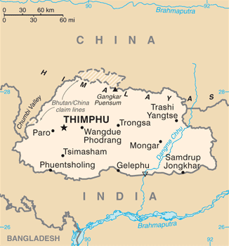
| تفصیل | Bhutan map from CIA World Factbook (since June 24, 2010) |
| تریخ | |
| سروت |
CIA World Factbook, converted from original GIF format |
| لکھاری | United States Central Intelligence Agency |
| دوجے ورژن |
|
لائسنس –
This image is in the public domain because it contains materials that originally came from the United States Central Intelligence Agency's World Factbook.
|
 |
فائل دی تریخ
فائل نو اس ویلے دی حالت وچ ویکھن واسطے تاریخ/ویلے تے کلک کرو۔
| تریخ تے ویلہ | نکی مورت | پاسے | ورتن والا | تیپّݨی کرو | |
|---|---|---|---|---|---|
| موجودہ | ۰۰:۴۰, ۷ جولائی ۲۰۱۷ | | ۳۲۶ × ۳۵۰ (۱۶ کلوبائٹ) | Ras67 | cropped, opt. |
| ۱۶:۵۶, ۱۲ مئی ۲۰۱۵ |  | ۳۳۰ × ۳۵۴ (۵۲ کلوبائٹ) | Evolt | Updated to version as of April 24, 2015 | |
| ۱۷:۱۷, ۲۲ اگست ۲۰۱۱ |  | ۳۳۰ × ۳۵۴ (۱۸ کلوبائٹ) | Zyxw | =={{int:filedesc}}== {{Information | Description = Bhutan map from CIA World Factbook ([http://web.archive.org/web/20100704230847/https://www.cia.gov/library/publications/the-world-factbook/geos/bt.html since June 24, 2010]) | Source = CIA World Factbook, |
فائل دی ورتوں
تھلے دتے گئے 1 صفحے اس فائل نال جُڑدے نیں
فائل ویاپک ورتوں
ایہہ دوجے وکیاں ایس فائل نوں ورتدے نیں –
- ace.wikipedia.org تے ورتوں
- af.wikipedia.org تے ورتوں
- als.wikipedia.org تے ورتوں
- ar.wikipedia.org تے ورتوں
- as.wikipedia.org تے ورتوں
- bcl.wikipedia.org تے ورتوں
- bh.wikipedia.org تے ورتوں
- bjn.wikipedia.org تے ورتوں
- bn.wikipedia.org تے ورتوں
- ca.wikipedia.org تے ورتوں
- cy.wikipedia.org تے ورتوں
- da.wikipedia.org تے ورتوں
- de.wikipedia.org تے ورتوں
- de.wiktionary.org تے ورتوں
- dv.wikipedia.org تے ورتوں
- dz.wikipedia.org تے ورتوں
- en.wikipedia.org تے ورتوں
- en.wiktionary.org تے ورتوں
- eo.wikipedia.org تے ورتوں
- es.wikipedia.org تے ورتوں
- eu.wikipedia.org تے ورتوں
- fa.wikipedia.org تے ورتوں
- fi.wikipedia.org تے ورتوں
ایس فائل دا ویکھو ہور جگت ورتن .