فائل:Byzantine Constantinople-en.png

Page contents not supported in other languages.
آزاد انسائیکلوپیڈیا، وکیپیڈیا توں

اصل فائل(۳,۲۰۰ × ۲,۸۸۸ پکسلز, فائل حجم: ۲.۳۵ میگابائٹ, MIME type: image/png)

ایہ فائل Wikimedia Commons توں اے تے دوجیاں ویونتاں تے وی ورتی جاسکدی اے۔ گل بات اس دے فائل گل بات صفحہ تے تھلے دتی گئی۔

وکیپیڈیا

 This is a featured picture on the English language Wikipedia (Featured pictures) and is considered one of the finest images. See its nomination here.

If you think this file should be featured on Wikimedia Commons as well, feel free to nominate it.
If you have an image of similar quality that can be published under a suitable copyright license, be sure to upload it, tag it, and nominate it.

خلاصہ

تفصیل
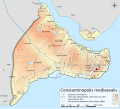
English: Topographical map of Constantinople during the Byzantine period.
Български: Топографска карта на Константинопол (Цариград) през византийския период. Източник: R. Janin, Constantinople Byzantine. Developpement urbain et repertoire topographique. Пътната мрежа и някои други детайли се основават на Dumbarton Oaks Papers 54 и други публикувани източници.
Deutsch: Topografische Karte Konstantinopels während des byzantinischen Zeitraums. Quelle: R. Janin, Constantinople Byzantine. Developpement urbain et repertoire topographique. Straßennetz und andere Einzelheiten basiert auf Dumbarton Oaks Papers 54. Kirchen, insb. nicht identifizierte und ausgegrabene Bauten sind aus dem The Byzantine Churches of Istanbul entnommen. Andere herausgegebenen Quellen wurden behilfsmäßig gebraucht.
Ελληνικά: Τοπογραφικός χάρτης Κωνσταντινουπόλεως κατά τη Βυζαντινή περίοδο. Βασική πηγή χάρτη: R. Janin, Constantinople Byzantine. Developpement urbain et repertoire topographique. Το οδικό δίκτυο και διάφορες άλλες λεπτομέρειες με βάση το Dumbarton Oaks Papers 54. Πληροφορίες για τις εκκλησίες, ιδιαίτερα τις μη ταυτοποιημένες, από την ιστοσελίδα The Byzantine Churches of Istanbul του Πανεπιστημίου της Νέας Υόρκης.
Although I've striven to make this map as complete and correct as possible, there may be some errors or omissions. Any corrections & suggestions are welcome.
تریخ
سروت

Own work using:

لکھاری Cplakidas
اجازت
(فائل نوں دوبارہ ورتنا)
میں، اس کم دے کاپیرائٹ دا مالک، اس کم نوں اس لائسنس دے مطابق چھاپدا واں:
w:en:Creative Commons
کس دے ناں اکو جہا شئیر کرو۔
ایس فائل نوں کریٹو کامنز Attribution 2.5 پولینڈ لائسنس دتا گیا.
تہانوں کھلھ اے:
  • حصہ کرنا – کاپی، ونڈنا تے کم بھیجنا
  • فیر رلانا – کم نوں فٹ کرنا
تھلے دتیاں شرطاں نال:
  • کس دے ناں – تسیں لازمی ایس کم دے بناں والے بارے دسو جنج اونے آکھیا اے یا جنج لسنس چ آکھیا گیا ہے۔
  • اکو جہا شئیر کرو۔ – اگر تسیں بدلدے یا ایس کم تے بناندے تے بنن والے کم نوں اینج دے لسنس نال ای ونڈو گے۔
GNU head کاپی کرن، ونڈن تے بدلن دی ایس ڈوکومنٹ ل‏ئی اجازت دتی جاندی اے ایہناں GNU Free Documentation License, Version 1.2 شرطاں نال یا مگروں کسے وی چھپے ورین Free Software Foundation توں بنا کسے انویرینٹ سیکشن دے، ناں فرنٹ کور لکھت تے ناں بیک کور لکھت دے۔ لسنس دی اک کاپی سیکشن وچ ہیگی اے جہدا ناں اے GNU Free Documentation License۔
تسیں اپنی مرضی دا لائسنس چݨ سکدے اوہ۔
دوجے ورژن

[سودھو]

Full maps

SVG:

PNG:

Numeric versions

Regions

Roads

Open this image as an overlay in Google Earth (Google Maps, Bing) (Help|Source)

Captions

Add a one-line explanation of what this file represents
Constantinople during the Byzantine period

Items portrayed in this file

چترن

copyrighted English

۲۸ اکتوبر 2008

MIME type English

image/png

checksum English

b4b5347456038e42cfa57b6c9763eaefb8d38a55

determination method English: ؜SHA-1 English

data size English

۲,۴۶۲,۲۳۵ بائٹ

height English

۲,۸۸۸ pixel

width English

۳,۲۰۰ pixel

فائل دی تریخ

فائل نو اس ویلے دی حالت وچ ویکھن واسطے تاریخ/ویلے تے کلک کرو۔

تریخ تے ویلہنکی مورتپاسےورتن والاتیپّݨی کرو
موجودہ۲۲:۴۲, ۲۵ اپریل ۲۰۱۰۲۲:۴۲, ۲۵ اپریل ۲۰۱۰ ویلے دے ورژن ساتھ انگوٹھاکار روپ۳,۲۰۰ × ۲,۸۸۸ (۲.۳۵ میگابائٹ)MahahahaneapneapCompressed
۱۷:۵۶, ۱۵ دسمبر ۲۰۰۹۱۷:۵۶, ۱۵ دسمبر ۲۰۰۹ ویلے دے ورژن ساتھ انگوٹھاکار روپ۳,۲۰۰ × ۲,۸۸۸ (۳.۴۲ میگابائٹ)Cplakidaslarger & more detailed version, various corrections, Galata included
۰۴:۰۸, ۱ جولائی ۲۰۰۹۰۴:۰۸, ۱ جولائی ۲۰۰۹ ویلے دے ورژن ساتھ انگوٹھاکار روپ۲,۱۳۴ × ۲,۰۰۰ (۱.۶۲ میگابائٹ)FalcorianLossless compression with pngout.
۰۳:۴۷, ۹ جنوری ۲۰۰۹۰۳:۴۷, ۹ جنوری ۲۰۰۹ ویلے دے ورژن ساتھ انگوٹھاکار روپ۲,۱۳۴ × ۲,۰۰۰ (۱.۸۴ میگابائٹ)Cplakidasmore info, minor tweaks & corrections
۱۶:۴۸, ۲۸ اکتوبر ۲۰۰۸۱۶:۴۸, ۲۸ اکتوبر ۲۰۰۸ ویلے دے ورژن ساتھ انگوٹھاکار روپ۲,۱۳۴ × ۲,۰۰۰ (۱.۷۶ میگابائٹ)Cplakidas{{Information |Description={{en|1=Topographical map of Constantinople during the Byzantine period. Map source: R. Janin, ''Constantinople Byzantine. Developpement urbain et repertoire topographique''. Road network and some other d

تھلے دتے گئے 3 صفحے اس فائل نال جُڑدے نیں

فائل ویاپک ورتوں

ایہہ دوجے وکیاں ایس فائل نوں ورتدے نیں –

ایس فائل دا ویکھو ہور جگت ورتن .

میٹا ڈیٹا