
فائل:Carte Empire-Khmer.png
اس توں وڈی مورت موجود نہیں۔
Carte_Empire-Khmer.png (۴۳۵ × ۴۴۵ پکسلز, فائل حجم: ۳۳ کلوبائٹ, MIME type: image/png)
خلاصہ
| تفصیل |
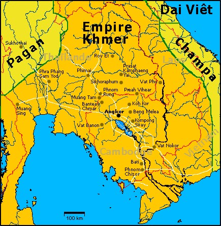
Carte de l'empire khmer à son apogée, au XIIe siècle sous Jayavarman VII avec les principaux sites visibles aujourd'hui. Illustration personnelle libre de droits sur base d'une carte OMC. English: French Map of Khmer Empire under Jayavarman VII. |
| تریخ | ۸ اگست ۲۰۰۵ (original upload date) |
| سروت | Transferred from fr.wikipedia to Commons. |
| لکھاری | Lozère at French وکیپیڈیا |
لائسنس –
| میں، اس کم دے کاپیرائٹ دا مالک، اس کم نوں لوکاں واسطے دیندا واں۔ اے سارے جگ واسطے لاگو اے۔ کج ملکاں چ قانونی طور تے اے ممکن نئیں اے؛ اگر انج ای اے ے: میں ہر کسے نوں اس کم نوں کسے وی مقصد واسطے ورتن دا بغیر کسے شرط دے حق دیندا واں، اگر اوہ قانون دے خلاف نا ہوۓ۔ |
پہلا اپلوڈ دا ریکارڈ
The original description page was here. All following user names refer to fr.wikipedia.
- 2006-04-15 20:33 Lozère 435×445×8 (33591 bytes) Avec les routes/With roads
- 2005-08-28 17:08 Lozère 435×445×8 (31287 bytes) Quelques ajouts
- 2005-08-09 19:51 Lozère 435×445×8 (44624 bytes) Etats actuels
- 2005-08-09 19:48 Lozère 435×445×8 (44246 bytes)
- 2005-08-08 15:02 Lozère 435×445×8 (29364 bytes) +Pagan
- 2005-08-08 14:31 Lozère 435×445×8 (41966 bytes) Carte de l'empire khmer à son apogée, au XIIe siècle sous Jayavarman VII avec les principaux sites visibles aujourd'hui. Illustration personnelle libre de droits sur base d'une carte OMC.
فائل دی تریخ
فائل نو اس ویلے دی حالت وچ ویکھن واسطے تاریخ/ویلے تے کلک کرو۔
| تریخ تے ویلہ | نکی مورت | پاسے | ورتن والا | تیپّݨی کرو | |
|---|---|---|---|---|---|
| موجودہ | ۲۳:۴۷, ۱۵ مارچ ۲۰۰۷ | | ۴۳۵ × ۴۴۵ (۳۳ کلوبائٹ) | Lozère | {{Information |Description=Carte de l'empire khmer à son apogée, au XIIe siècle sous Jayavarman VII avec les principaux sites visibles aujourd'hui. English: Map of Khmer Empire under Jayavarman VII. |Source=Own work, on the basis of an OMC map. |Date=1 |
| ۰۲:۱۵, ۸ دسمبر ۲۰۰۶ |  | ۴۳۵ × ۴۴۵ (۳۱ کلوبائٹ) | Electionworld | {{ew|en|Ipower}} French Map of Khmer Empire under Jayavarman VII. == Licensing == {{PD}} Category:Maps of the history of Cambodia |
فائل دی ورتوں
تھلے دتے گئے 1 صفحے اس فائل نال جُڑدے نیں
فائل ویاپک ورتوں
ایہہ دوجے وکیاں ایس فائل نوں ورتدے نیں –
- ba.wikipedia.org تے ورتوں
- be.wikipedia.org تے ورتوں
- bn.wikipedia.org تے ورتوں
- bs.wikipedia.org تے ورتوں
- de.wikipedia.org تے ورتوں
- fa.wikipedia.org تے ورتوں
- fi.wikipedia.org تے ورتوں
- fi.wikibooks.org تے ورتوں
- fr.wikipedia.org تے ورتوں
- Architecture khmère
- Utilisateur:Lozère/Album
- Histoire du Cambodge
- Prasat Sdok Kok Thom
- Prasat Muang Sing
- Utilisateur:Ddalbiez
- Prasat Hin Phimai
- Prasat Phnom Wan
- Prang Khaek
- Wat Phra Sri Ratana Mahathat
- Phra Prang Sam Yod
- Kuti Reussi no 1
- Kuti Reussi no 2
- Prasat Sikhoraphum
- Prasat Tam Nak Sai
- Prasat Yer
- Prasat Sa Kamphaeng Yai
- Prasat Sa Kamphaeng Noi
- Prasat Ban Prasat
- Prasat Ban Muang Chan
- Prasat Prang Ku
- Prasat Hin Ban Samo
- Prasat Ta Leng
- Prasat Muang Tam
- Prasat Ban Bu
- Prasat Phum Pon
- Prasat Hin Chom Phra
- Prasat Sangkha
- Prasat Tha Piang Tia
- Prasat Phu Fai
- Prasat Ban Ben
- Prasat Yai Ngao
- Prasat Beng
- Prasat Ban Phluang
- Prasat Ta Muen
- Prasat Ta Muen Toch
- Prasat Ta Muen Thom
- Prasat Khao Lon
ایس فائل دا ویکھو ہور جگت ورتن .