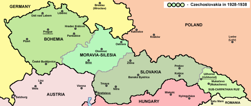
فائل:Czechoslovakia01.png

ایس وکھالے دا ناپ: ۸۰۰ × ۳۴۰ پکسلز۔ دوجے ریزولوشنز: ۳۲۰ × ۱۳۶ پکسلز | ۱,۱۰۰ × ۴۶۸ پکسلز ۔
اصل فائل (۱,۱۰۰ × ۴۶۸ پکسلز, فائل حجم: ۶۳ کلوبائٹ, MIME type: image/png)
فائل دی تریخ
فائل نو اس ویلے دی حالت وچ ویکھن واسطے تاریخ/ویلے تے کلک کرو۔
| تریخ تے ویلہ | نکی مورت | پاسے | ورتن والا | تیپّݨی کرو | |
|---|---|---|---|---|---|
| موجودہ | ۱۹:۴۸, ۱۲ جولائی ۲۰۲۲ |  | ۱,۱۰۰ × ۴۶۸ (۶۳ کلوبائٹ) | Sebastian Wallroth | cropped |
| ۱۵:۵۴, ۱۹ مئی ۲۰۱۱ |  | ۱,۱۲۸ × ۵۱۳ (۶۳ کلوبائٹ) | PANONIAN | minor change, marked provincial capitals | |
| ۱۴:۵۳, ۱۷ مئی ۲۰۱۱ |  | ۱,۱۲۸ × ۵۱۳ (۶۲ کلوبائٹ) | PANONIAN | Reverted to version as of 10:38, 24 April 2011 - because this is map of Czechoslovakia and it was capital of Czechoslovakia | |
| ۱۰:۰۷, ۱۷ مئی ۲۰۱۱ |  | ۱,۱۲۸ × ۵۱۳ (۵۵ کلوبائٹ) | Millenium187 | Why was Prague underlined and Vienna, Brno, Bratislava and other capital cities were not? -- corrected | |
| ۱۵:۳۸, ۲۴ اپریل ۲۰۱۱ |  | ۱,۱۲۸ × ۵۱۳ (۶۲ کلوبائٹ) | PANONIAN | few corrections | |
| ۱۶:۳۱, ۲۳ اپریل ۲۰۱۱ |  | ۱,۱۲۸ × ۵۰۹ (۶۱ کلوبائٹ) | PANONIAN | improved version | |
| ۰۱:۵۸, ۲۱ دسمبر ۲۰۰۸ |  | ۱,۱۰۰ × ۴۹۷ (۷۸ کلوبائٹ) | Kirk979 | {{Information |Description= |Source= |Date= |Author= |Permission= |other_versions= }} | |
| ۲۱:۱۱, ۲۸ دسمبر ۲۰۰۶ |  | ۱,۱۰۰ × ۴۹۷ (۹۰ کلوبائٹ) | Electionworld | {{ew|en|PANONIAN}} Map of {{link|Czechoslovakia}} (self made) Note: The provinces shown on the map were introduced by Act No. 125/1927 Zb. and became effective in 1928. {{PD-self}} Category:Maps of Czechoslovakia Category:Maps of Czech history |
فائل دی ورتوں
تھلے دتے گئے 1 صفحے اس فائل نال جُڑدے نیں
فائل ویاپک ورتوں
ایہہ دوجے وکیاں ایس فائل نوں ورتدے نیں –
- af.wikipedia.org تے ورتوں
- als.wikipedia.org تے ورتوں
- ang.wikipedia.org تے ورتوں
- an.wikipedia.org تے ورتوں
- ar.wikipedia.org تے ورتوں
- arz.wikipedia.org تے ورتوں
- azb.wikipedia.org تے ورتوں
- az.wikipedia.org تے ورتوں
- ba.wikipedia.org تے ورتوں
- bcl.wikipedia.org تے ورتوں
- be-tarask.wikipedia.org تے ورتوں
- be.wikipedia.org تے ورتوں
- bg.wikipedia.org تے ورتوں
- bn.wikipedia.org تے ورتوں
- br.wikipedia.org تے ورتوں
- ca.wikipedia.org تے ورتوں
- cs.wikipedia.org تے ورتوں
- cv.wikipedia.org تے ورتوں
- cy.wikipedia.org تے ورتوں
- de.wikipedia.org تے ورتوں
- diq.wikipedia.org تے ورتوں
- dsb.wikipedia.org تے ورتوں
- el.wikipedia.org تے ورتوں
- en.wikipedia.org تے ورتوں
ایس فائل دا ویکھو ہور جگت ورتن .


