
فائل:Herefordshire UK location map.svg

Size of this PNG preview of this SVG file: ۴۷۳ × ۵۹۹ پکسلز. دوجے ریزولوشنز: ۱۸۹ × ۲۴۰ پکسلز | ۳۷۹ × ۴۸۰ پکسلز | ۶۰۶ × ۷۶۸ پکسلز | ۸۰۸ × ۱,۰۲۴ پکسلز | ۱,۶۱۶ × ۲,۰۴۸ پکسلز | ۹۹۹ × ۱,۲۶۶ پکسلز ۔
اصل فائل (ایس وی جی فائل، پکسل:۹۹۹ × ۱,۲۶۶، فائل سائز: ۱.۵۵ میگابائٹ)
| تفصیل |
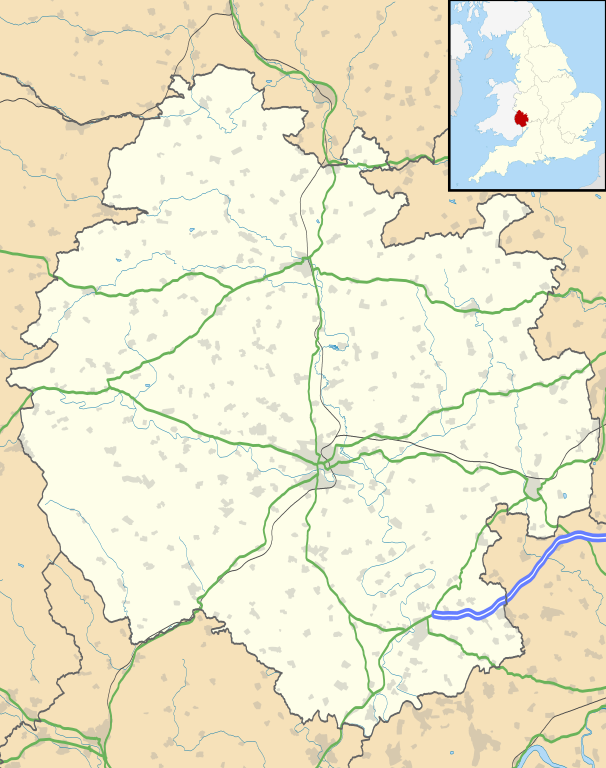
Map of Herefordshire, UK with the following information shown:
Equirectangular map projection on WGS 84 datum, with N/S stretched 160% Geographic limits:
|
| تریخ | |
| سروت |
|
| لکھاری | Nilfanion, created using Ordnance Survey data |
| اجازت (فائل نوں دوبارہ ورتنا) |
ایس فائل نوں کریٹو کامنز Attribution 2.5 پولینڈ لائسنس دتا گیا. کس دے ناں: Contains Ordnance Survey data © Crown copyright and database right
|
| دوجے ورژن | File:Herefordshire UK district map (blank).svg - Blank map |
.svg)
فائل دی تریخ
فائل نو اس ویلے دی حالت وچ ویکھن واسطے تاریخ/ویلے تے کلک کرو۔
| تریخ تے ویلہ | نکی مورت | پاسے | ورتن والا | تیپّݨی کرو | |
|---|---|---|---|---|---|
| موجودہ | ۲۳:۵۵, ۲۶ ستمبر ۲۰۱۰ | | ۹۹۹ × ۱,۲۶۶ (۱.۵۵ میگابائٹ) | Nilfanion | {{Information |Description=Map of Herefordshire, UK with the following information shown: *Administrative borders *Coastline, lakes and rivers *Roads and railways *Urban areas Equirectangular map projection on WGS 84 datum, with N/S s |
فائل دی ورتوں
تھلے دتے گئے 1 صفحے اس فائل نال جُڑدے نیں
فائل ویاپک ورتوں
ایہہ دوجے وکیاں ایس فائل نوں ورتدے نیں –
- ar.wikipedia.org تے ورتوں
- az.wikipedia.org تے ورتوں
- bg.wikipedia.org تے ورتوں
- ceb.wikipedia.org تے ورتوں
- cy.wikipedia.org تے ورتوں
- en.wikipedia.org تے ورتوں
- Hereford
- Kilpeck
- Eye, Herefordshire
- Symonds Yat
- Bacton, Herefordshire
- Leominster
- Kington, Herefordshire
- Ledbury
- Ross-on-Wye
- Bromyard
- Edvin Loach
- Weston under Penyard
- Pembridge
- Adforton
- Whitchurch, Herefordshire
- Welsh Bicknor
- Much Marcle
- Combe Moor
- Much Dewchurch
- Credenhill
- Welsh Newton
- Thornbury, Herefordshire
- Leintwardine
- List of places in Herefordshire
- Colwall
- Abbey Dore
- Weston Beggard
- Moreton on Lugg
- Peterchurch
- Cusop
- Weobley
- Llanwarne
- Pontrilas
- Yazor
- Eardisley
- Walford, Ross-on-Wye
- Little Hereford
- Preston on Wye
- Allensmore
- Hope under Dinmore
- Almeley
- Ashperton
- Aston Ingham
- Avenbury
ایس فائل دا ویکھو ہور جگت ورتن .