
فائل:Kerch Strait Landsat.jpg

ایس وکھالے دا ناپ: ۸۰۰ × ۶۰۰ پکسلز۔ دوجے ریزولوشنز: ۳۲۰ × ۲۴۰ پکسلز | ۶۴۰ × ۴۸۰ پکسلز | ۱,۰۲۴ × ۷۶۸ پکسلز | ۱,۲۸۰ × ۹۶۰ پکسلز | ۱,۶۰۰ × ۱,۲۰۰ پکسلز ۔
اصل فائل (۱,۶۰۰ × ۱,۲۰۰ پکسلز, فائل حجم: ۲۹۴ کلوبائٹ, MIME type: image/jpeg)
خلاصہ
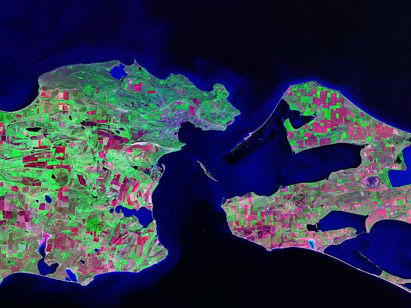
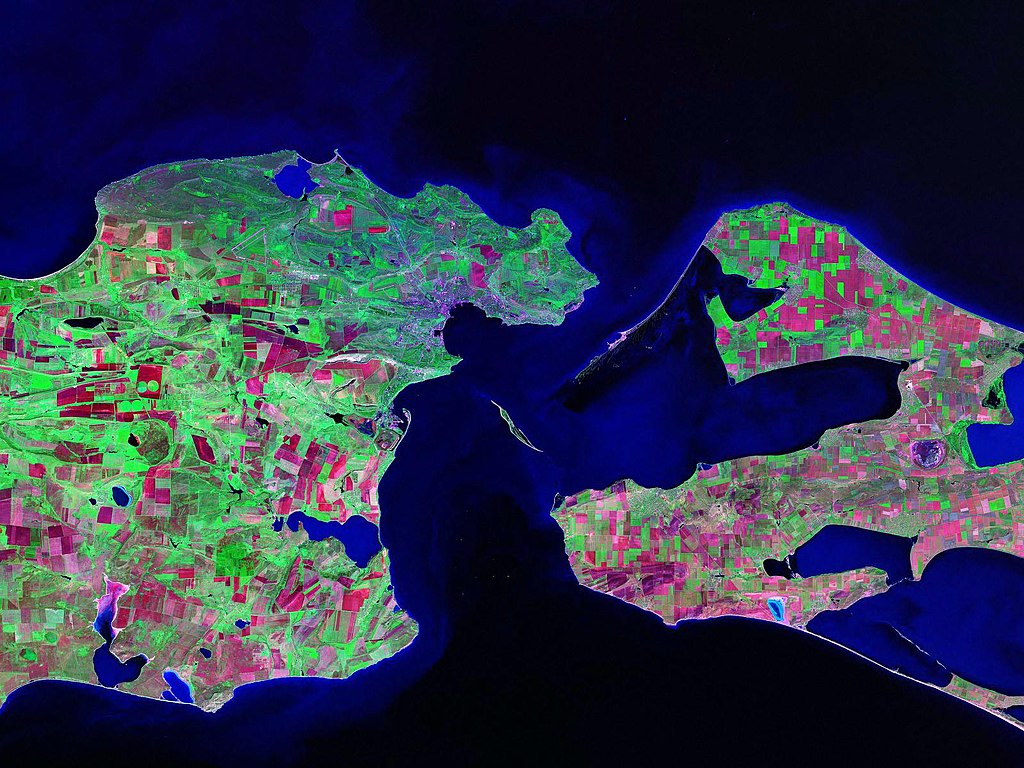
Landsat satellite (false color) photo of Kerch Strait between the Sea of Azov and the Black Sea.
Source: zulu.ssc.nasa.gov
| Camera location | | View this and other nearby images on: OpenStreetMap |
|---|
لائسنس –
| This file is in the public domain in the United States because it was solely created by NASA. NASA copyright policy states that "NASA material is not protected by copyright unless noted". (See Template:PD-USGov, NASA copyright policy page or JPL Image Use Policy.) | ||
 |
Warnings:
|
فائل دی تریخ
فائل نو اس ویلے دی حالت وچ ویکھن واسطے تاریخ/ویلے تے کلک کرو۔
| تریخ تے ویلہ | نکی مورت | پاسے | ورتن والا | تیپّݨی کرو | |
|---|---|---|---|---|---|
| موجودہ | ۱۸:۵۲, ۱۷ اکتوبر ۲۰۰۶ | | ۱,۶۰۰ × ۱,۲۰۰ (۲۹۴ کلوبائٹ) | Balcer~commonswiki | Landsat satellite (false color) photo of Kerch Strait between the Sea of Azov and the Black Sea. Source:zulu.ssc.nasa.gov Category:Black Sea Category:Satellite pictures of Russia Category:Satellite pictures of Ukraine |
فائل دی ورتوں
تھلے دتے گئے 1 صفحے اس فائل نال جُڑدے نیں
فائل ویاپک ورتوں
ایہہ دوجے وکیاں ایس فائل نوں ورتدے نیں –
- be.wikipedia.org تے ورتوں
- ca.wikipedia.org تے ورتوں
- ceb.wikipedia.org تے ورتوں
- crh.wikipedia.org تے ورتوں
- cs.wikipedia.org تے ورتوں
- de.wikipedia.org تے ورتوں
- el.wikipedia.org تے ورتوں
- en.wikipedia.org تے ورتوں
- eo.wikipedia.org تے ورتوں
- es.wikipedia.org تے ورتوں
- fa.wikipedia.org تے ورتوں
- fi.wikipedia.org تے ورتوں
- fr.wikipedia.org تے ورتوں
- hr.wikipedia.org تے ورتوں
- hy.wikipedia.org تے ورتوں
- it.wikipedia.org تے ورتوں
- ko.wikipedia.org تے ورتوں
- nn.wikipedia.org تے ورتوں
- no.wikipedia.org تے ورتوں
- pl.wikipedia.org تے ورتوں
- pt.wikipedia.org تے ورتوں
- ru.wikipedia.org تے ورتوں
- sk.wikipedia.org تے ورتوں
- sv.wikipedia.org تے ورتوں
- tr.wikipedia.org تے ورتوں
- ug.wikipedia.org تے ورتوں
- uk.wikipedia.org تے ورتوں
- Конфлікт щодо острова Тузла
- Керченська протока
- Користувач:Alex Blokha/Події в Вікіпедії/6 жовтня
- Користувач:Alex Blokha/Події в Вікіпедії/23 жовтня
- Користувач:Alex Blokha/Події в Вікіпедії/2 грудня
- Користувач:Alex Blokha/Події в Вікіпедії/7 січня
- Користувач:Alex Blokha/Події в Вікіпедії/19 лютого
- Державний кордон України
- Користувач:Alex Blokha/Дні згадані в Вікіпедії/Україна/6 жовтня
- Користувач:Alex Blokha/Дні згадані в Вікіпедії/Україна/22 жовтня
- Користувач:Alex Blokha/Дні згадані в Вікіпедії/Україна/2 грудня
- Користувач:Alex Blokha/Дні згадані в Вікіпедії/Україна/7 січня
- Президентство Леоніда Кучми
ایس فائل دا ویکھو ہور جگت ورتن .