
فائل:Kotayk.svg

Size of this PNG preview of this SVG file: ۵۸۷ × ۵۹۹ پکسلز. دوجے ریزولوشنز: ۲۳۵ × ۲۴۰ پکسلز | ۴۷۰ × ۴۸۰ پکسلز | ۷۵۲ × ۷۶۸ پکسلز | ۱,۰۰۳ × ۱,۰۲۴ پکسلز | ۲,۰۰۶ × ۲,۰۴۸ پکسلز | ۷۲۵ × ۷۴۰ پکسلز ۔
اصل فائل (ایس وی جی فائل، پکسل:۷۲۵ × ۷۴۰، فائل سائز: ۷۲ کلوبائٹ)
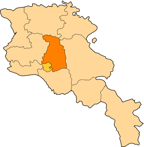
| تفصیل | Image shows the eleven administrative subdivisions of Armenia: # Aragatsotn (Արագածոտնի) # Ararat (Արարատի) # Armavir (Արմավիրի) # Gegharkunik (Գեղարքունիքի) # Kotayk (Կոտայքի) # Lori (Լոռու) # Shirak (Շիրակի) # Syunik (Սյունիքի) # Tavush (Տավուշի) # Vayots Dzor (Վայոց Ձորի) # Yerevan (Երևան) - special administrative status Derived from a multiple of public sources and created using Inkscape. == |
| تریخ | (UTC) |
| سروت | |
| لکھاری |
|
| This is a retouched picture, which means that it has been digitally altered from its original version. Modifications: Creation d'une autre map. The original can be viewed here: Armenia map numbered.svg:
|
ایس فائل نوں کریٹو کامنز Attribution 2.5 پولینڈ لائسنس دتا گیا.
- تہانوں کھلھ اے:
- حصہ کرنا – کاپی، ونڈنا تے کم بھیجنا
- فیر رلانا – کم نوں فٹ کرنا
- تھلے دتیاں شرطاں نال:
- کس دے ناں – تسیں لازمی ایس کم دے بناں والے بارے دسو جنج اونے آکھیا اے یا جنج لسنس چ آکھیا گیا ہے۔
- اکو جہا شئیر کرو۔ – اگر تسیں بدلدے یا ایس کم تے بناندے تے بنن والے کم نوں اینج دے لسنس نال ای ونڈو گے۔
پہلا اپلوڈ دا ریکارڈ
This image is a derivative work of the following images:
- File:Armenia_map_numbered.svg licensed with Cc-by-sa-3.0-migrated, GFDL
- 2010-09-26T17:27:10Z 6AND5 725x740 (82221 Bytes) Reverted to version as of 17:31, 25 November 2006 (((Exclaves deleted according to official map at http://www.gov.am/en/regions/)))
- 2006-11-25T19:37:43Z Bastique 725x740 (87638 Bytes) Cleanup
- 2006-11-25T19:26:57Z Bastique 725x740 (86083 Bytes) Enclaves
- 2006-11-25T17:31:38Z Bastique 725x740 (82221 Bytes) Fixed canvas size
- 2006-11-25T17:27:59Z Bastique 744x1052 (79767 Bytes) Image shows the subdivisions of Armenia. Derived from a multiple of public sources and created using Inkscape. == Licensing == {{GFDL}} Image shows the eleven administrative subdivisions of Armenia: #[[Aragatsotn]] (Ար�
Uploaded with derivativeFX
فائل دی تریخ
فائل نو اس ویلے دی حالت وچ ویکھن واسطے تاریخ/ویلے تے کلک کرو۔
| تریخ تے ویلہ | نکی مورت | پاسے | ورتن والا | تیپّݨی کرو | |
|---|---|---|---|---|---|
| موجودہ | ۱۶:۲۰, ۳۰ دسمبر ۲۰۱۰ | | ۷۲۵ × ۷۴۰ (۷۲ کلوبائٹ) | Varmin | {{Information |Description=Image shows the eleven administrative subdivisions of Armenia: # Aragatsotn (Արագածոտնի) # Ararat (Արարատի) # Armavir (Արմավիրի) # Gegharkunik (Գեղ |
فائل دی ورتوں
تھلے دتے گئے 1 صفحے اس فائل نال جُڑدے نیں
فائل ویاپک ورتوں
ایہہ دوجے وکیاں ایس فائل نوں ورتدے نیں –
- ar.wikipedia.org تے ورتوں
- be.wikipedia.org تے ورتوں
- bg.wikipedia.org تے ورتوں
- ceb.wikipedia.org تے ورتوں
- ce.wikipedia.org تے ورتوں
ایس فائل دا ویکھو ہور جگت ورتن .