
فائل:Landsat-emirau-island-adjusted.png
اس توں وڈی مورت موجود نہیں۔
Landsat-emirau-island-adjusted.png (۵۶۸ × ۳۴۸ پکسلز, فائل حجم: ۷۷۴ کلوبائٹ, MIME type: image/png)
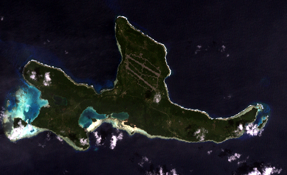
Orthocorrected Landsat 7 image of Emirau Island, New Ireland province, Papua New Guinea. Acquired 2000-II-6; orthocorrected by EarthSat. Source for this dataset was the Global Land Cover Facility archive copy at the Wayback Machine. Levels have been adjusted using GIMP. This is a public domain image.
This image is in the public domain in the United States because it only contains materials that originally came from the United States Geological Survey, an agency of the United States Department of the Interior. For more information, see the official USGS copyright policy.
|
فائل دی تریخ
فائل نو اس ویلے دی حالت وچ ویکھن واسطے تاریخ/ویلے تے کلک کرو۔
| تریخ تے ویلہ | نکی مورت | پاسے | ورتن والا | تیپّݨی کرو | |
|---|---|---|---|---|---|
| موجودہ | ۲۳:۰۰, ۱۴ مئی ۲۰۰۵ | | ۵۶۸ × ۳۴۸ (۷۷۴ کلوبائٹ) | Dmoews~commonswiki | Orthocorrected Landsat 7 image of Emirau Island, New Ireland province, Papua New Guinea. Acquired 2000-II-6; orthocorrected by [http://www.earthsat.com/ EarthSat]. Source for this dataset was the [http://www.landcover.org/ Global Land Cover Facility]. |
فائل دی ورتوں
تھلے دتے گئے 1 صفحے اس فائل نال جُڑدے نیں
فائل ویاپک ورتوں
ایہہ دوجے وکیاں ایس فائل نوں ورتدے نیں –
- en.wikipedia.org تے ورتوں
- fr.wikipedia.org تے ورتوں
- gl.wikipedia.org تے ورتوں
- it.wikipedia.org تے ورتوں
- ja.wikipedia.org تے ورتوں
- nl.wikipedia.org تے ورتوں
- www.wikidata.org تے ورتوں
- zh.wikipedia.org تے ورتوں