
فائل:Map Dutch World scris.png
ایس وکھالے دا ناپ: ۸۰۰ × ۳۵۱ پکسلز۔ دوجے ریزولوشنز: ۳۲۰ × ۱۴۰ پکسلز | ۶۴۰ × ۲۸۱ پکسلز | ۱,۴۲۵ × ۶۲۵ پکسلز ۔
اصل فائل (۱,۴۲۵ × ۶۲۵ پکسلز, فائل حجم: ۶۱ کلوبائٹ, MIME type: image/png)
خلاصہ
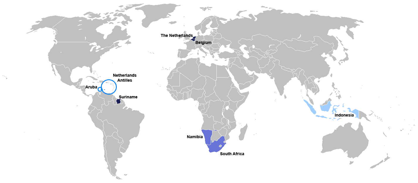
New map for Dutch-speaking world with country names. Modified version of Image:Map Dutch World nou.png
Deutsch: Legende:
- Dunkelblau: Mutter- und Mehrheitssprache
- Blau: Afrikaans (Tochtersprache)
- Hellblau: Zweit- oder nicht offizielle Sprache bzw. weiterhin vorhandene Kenntnis
English: English: Legend:
- Dark blue: native and majority language
- Blue: Afrikaans (daughter language)
- Light blue: secondary (non-official language), where some knowledge persists
Français : Français : Légende:
- Bleu foncé : langue maternelle et majoritaire
- Bleu : Afrikaans («langue fille»)
- Bleu clair : langue secondaire ou non officielle
Italiano: Italiano: Legenda:
- Blu scuro: lingua madre e maggioritaria
- Blu: Afrikaans (lingua affiliata)
- Blu chiaro: seconda lingua e/o non ufficiale, dove la sua conoscenza persiste sino ad oggi
Nederlands: Nederlands: Legenda:
- Donkerblauw: Moedertaal en belangrijkste taal
- Blauw: Afrikaans (dochtertaal)
- Lichtblauw: secundaire taal (niet-officiële taal), waar enkele kennis bestaat
Português: Português: Legenda:
- Azul escuro: língua mãe e majoritária
- Azul: Africâner (língua descendente)
- Azul claro: língua secundária (não oficial), onde ainda persiste algum conhecimento
Română: Română: Legendă:
- Albastru închis: limbă naţională
- Albastru: Afrikaans
- Albastru deschis: limbă secundară, neoficială
Español: Español : Leyenda:
- Azul obscuro : lengua materna y mayoritaria
- Azul : Afrikaans (lengua «hija»)
- Azul claro : lengua secundaria (no oficial), donde aún persiste conocimiento de ella.

|
This file has been superseded by Map of the Dutch World.svg. It is recommended to use the other file. Please note that deleting superseded images requires consent.
|

|
File:Map of the Dutch World.svg is a vector version of this file. It should be used in place of this PNG file.
File:Map Dutch World scris.png → File:Map of the Dutch World.svg
For more information, see Help:SVG. |
 |
لائسنس –
میں، اس کم دے کاپیرائٹ دا مالک، اس کم نوں اس لائسنس دے مطابق چھاپدا واں:

|
کاپی کرن، ونڈن تے بدلن دی ایس ڈوکومنٹ لئی اجازت دتی جاندی اے ایہناں GNU Free Documentation License, Version 1.2 شرطاں نال یا مگروں کسے وی چھپے ورین Free Software Foundation توں بنا کسے انویرینٹ سیکشن دے، ناں فرنٹ کور لکھت تے ناں بیک کور لکھت دے۔ لسنس دی اک کاپی سیکشن وچ ہیگی اے جہدا ناں اے GNU Free Documentation License۔ |
| ایس فائل نوں کریٹو کامنز Attribution 2.5 پولینڈ لائسنس دتا گیا. | ||
| ||
| اس لائسنس دا ٹیگ GFDL دے مطابق اس فائل چ پایا گیا اے licensing update۔ |
فائل دی تریخ
فائل نو اس ویلے دی حالت وچ ویکھن واسطے تاریخ/ویلے تے کلک کرو۔
| تریخ تے ویلہ | نکی مورت | پاسے | ورتن والا | تیپّݨی کرو | |
|---|---|---|---|---|---|
| موجودہ | ۰۰:۰۶, ۸ جولائی ۲۰۱۰ | | ۱,۴۲۵ × ۶۲۵ (۶۱ کلوبائٹ) | Hooiwind | deeper colours so it is easier to see the countries on a smaller scale + removal of "minority dots", geographically confusing and pretty arbitrary. |
| ۲۲:۴۶, ۱۶ فروری ۲۰۰۷ |  | ۱,۴۲۵ × ۶۲۵ (۳۴ کلوبائٹ) | Danutz | New map for Dutch-speaking world with country names. Modified version of Image:Map Dutch World nou.png English: Legend: *Dark blue: native language *Blue: administrative language *Light blue: secondary, non-official language *Green square: minori |
فائل دی ورتوں
اس فائل نال جڑیا کوئی صفحہ نئیں۔
فائل ویاپک ورتوں
ایہہ دوجے وکیاں ایس فائل نوں ورتدے نیں –
- jv.wikipedia.org تے ورتوں
- nl.wikibooks.org تے ورتوں
- sat.wikipedia.org تے ورتوں