
فائل:Map of Montana highlighting Missoula County.svg

Size of this PNG preview of this SVG file: ۸۰۰ × ۴۶۱ پکسلز. دوجے ریزولوشنز: ۳۲۰ × ۱۸۵ پکسلز | ۶۴۰ × ۳۶۹ پکسلز | ۱,۰۲۴ × ۵۹۱ پکسلز | ۱,۲۸۰ × ۷۳۸ پکسلز | ۲,۵۶۰ × ۱,۴۷۷ پکسلز | ۹,۱۹۴ × ۵,۳۰۳ پکسلز ۔
اصل فائل (ایس وی جی فائل، پکسل:۹,۱۹۴ × ۵,۳۰۳، فائل سائز: ۱۲۲ کلوبائٹ)
خلاصہ
| تفصیل |
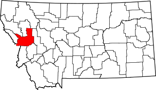
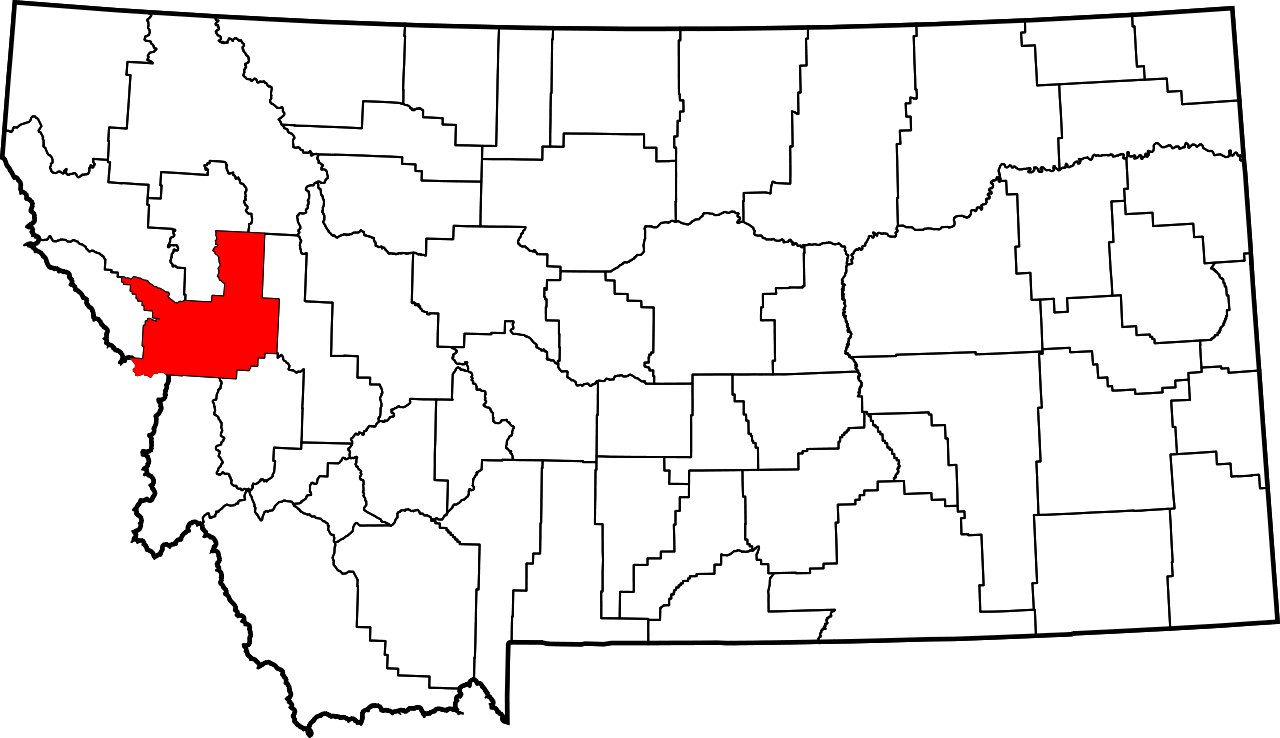
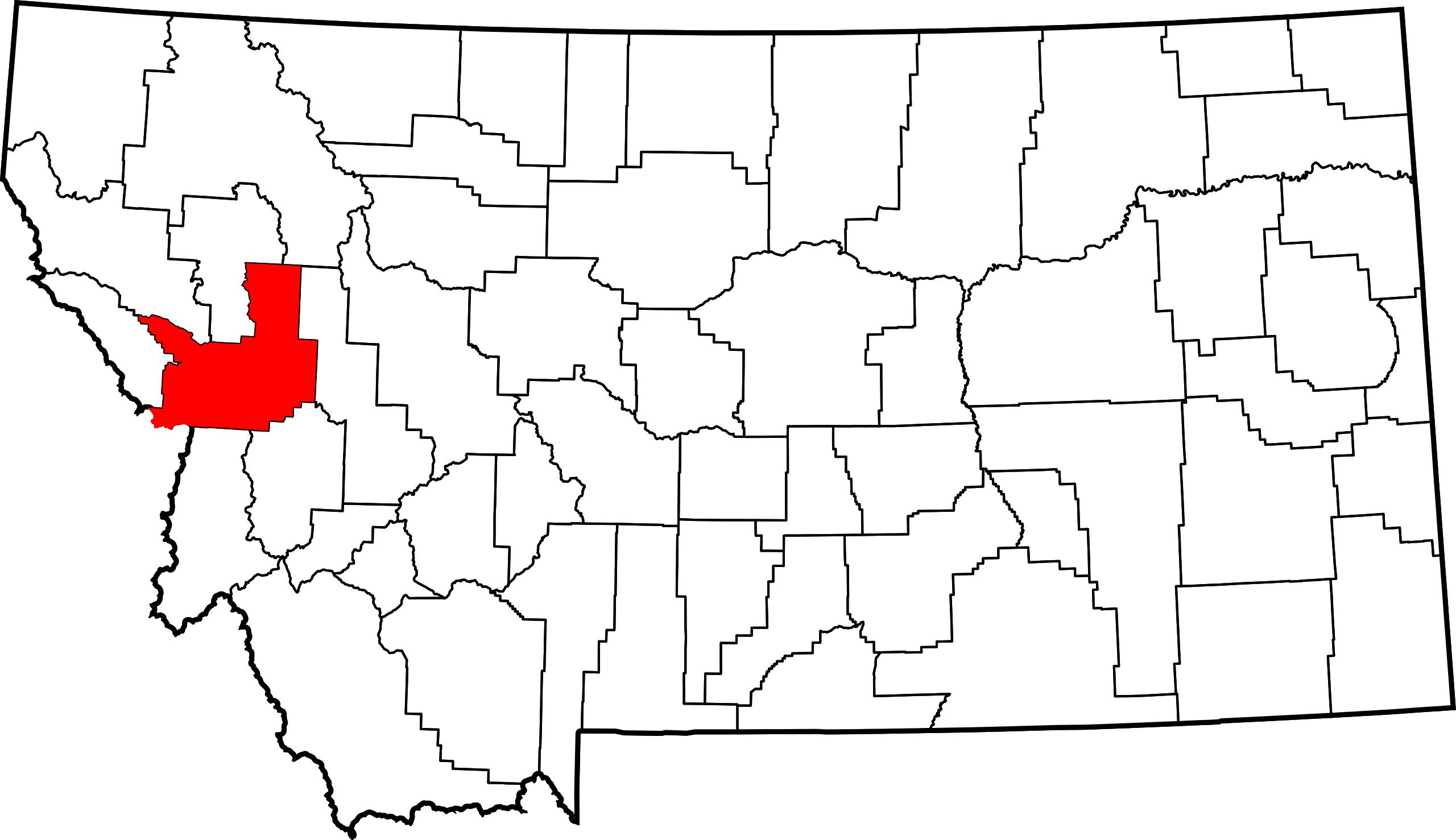
English: This is a locator map showing Missoula County in Montana. For more information, see Commons:United States county locator maps. |
| تریخ | |
| سروت |
آپݨا کم: English: The maps use data from nationalatlas.gov, specifically countyp020.tar.gz on the Raw Data Download page. The maps also use state outline data from statesp020.tar.gz. The Florida maps use hydrogm020.tar.gz to display Lake Okeechobee. |
| لکھاری | David Benbennick |
لائسنس –
| میں، اس کم دے کاپیرائٹ دا مالک، اس کم نوں لوکاں واسطے دیندا واں۔ اے سارے جگ واسطے لاگو اے۔ کج ملکاں چ قانونی طور تے اے ممکن نئیں اے؛ اگر انج ای اے ے: میں ہر کسے نوں اس کم نوں کسے وی مقصد واسطے ورتن دا بغیر کسے شرط دے حق دیندا واں، اگر اوہ قانون دے خلاف نا ہوۓ۔ |
فائل دی تریخ
فائل نو اس ویلے دی حالت وچ ویکھن واسطے تاریخ/ویلے تے کلک کرو۔
| تریخ تے ویلہ | نکی مورت | پاسے | ورتن والا | تیپّݨی کرو | |
|---|---|---|---|---|---|
| موجودہ | ۱۸:۳۰, ۱۲ فروری ۲۰۰۶ | | ۹,۱۹۴ × ۵,۳۰۳ (۱۲۲ کلوبائٹ) | David Benbennick | {{subst:User:Dbenbenn/clm|county=Missoula County|state=Montana|type=county}} |
فائل دی ورتوں
تھلے دتے گئے 1 صفحے اس فائل نال جُڑدے نیں
فائل ویاپک ورتوں
ایہہ دوجے وکیاں ایس فائل نوں ورتدے نیں –
- ar.wikipedia.org تے ورتوں
- bg.wikipedia.org تے ورتوں
- bpy.wikipedia.org تے ورتوں
- ca.wikipedia.org تے ورتوں
- cdo.wikipedia.org تے ورتوں
- ceb.wikipedia.org تے ورتوں
- cy.wikipedia.org تے ورتوں
- de.wikipedia.org تے ورتوں
- en.wikipedia.org تے ورتوں
- List of counties in Montana
- Missoula County, Montana
- Bonner-West Riverside, Montana
- Clinton, Montana
- East Missoula, Montana
- Evaro, Montana
- Frenchtown, Montana
- Lolo, Montana
- Missoula, Montana
- Orchard Homes, Montana
- Seeley Lake, Montana
- Wye, Montana
- Flathead Indian Reservation
- Lolo Hot Springs, Montana
- User:Nyttend/County templates/MT
- Template:Missoula County, Montana
ایس فائل دا ویکھو ہور جگت ورتن .