
فائل:Mecklenburg-Vorpommern Map Districts Border Mecklenburg Western Pomerania - Landkreise Grenzen Karte MV MeckPomm.svg

Size of this PNG preview of this SVG file: ۸۰۰ × ۵۴۹ پکسلز. دوجے ریزولوشنز: ۳۲۰ × ۲۲۰ پکسلز | ۶۴۰ × ۴۳۹ پکسلز | ۱,۰۲۴ × ۷۰۳ پکسلز | ۱,۲۸۰ × ۸۷۹ پکسلز | ۲,۵۶۰ × ۱,۷۵۷ پکسلز | ۱,۱۲۹ × ۷۷۵ پکسلز ۔
اصل فائل (ایس وی جی فائل، پکسل:۱,۱۲۹ × ۷۷۵، فائل سائز: ۷۵۹ کلوبائٹ)
خلاصہ
| تفصیل |
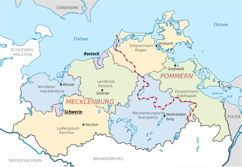
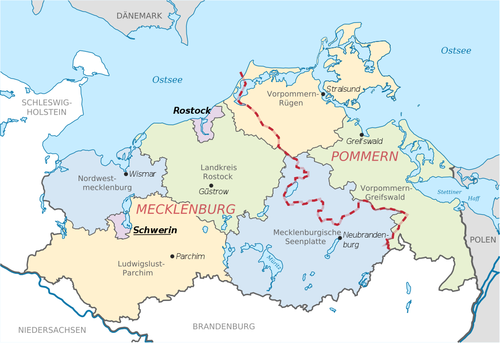
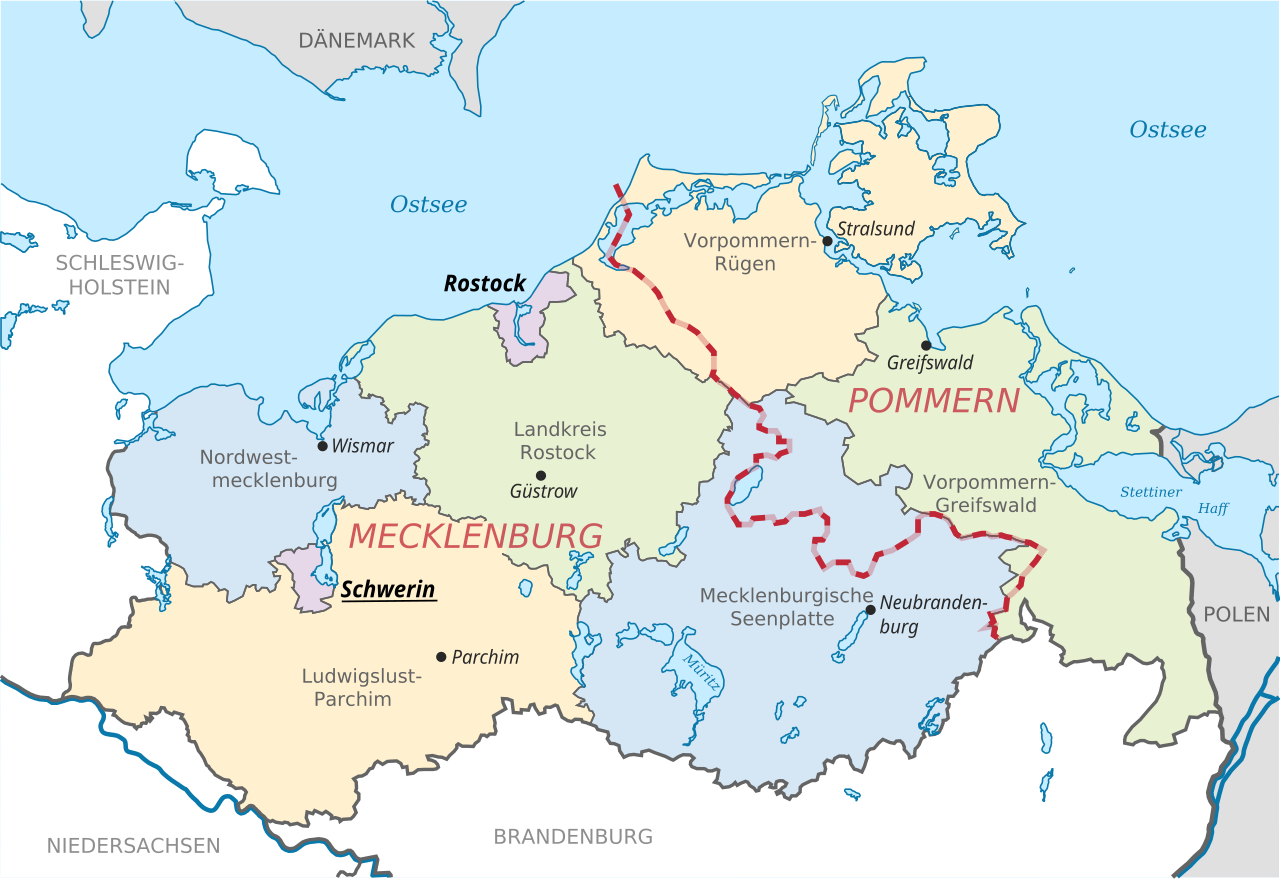
English: Locator map of counties and their seats in Mecklenburg-Vorpommern, Germany after county reorganization 2011. The red-white line indicates the former border between the state of Mecklenburg and the Prussian province of Pommerania.
Deutsch: Karte mit Lage der Landkreise und Kreisstädte in Mecklenburg-Vorpommern, Deutschland nach der Kreisgebietsreform 2011. Eingezeichnet ist auch die Grenze zwischen dem früheren Staat Mecklenburg und der preußischen Provinz Pommern. |
| تریخ | |
| سروت | File:Mecklenburg-Vorpommern districts 2011 colored labeled Meck-Pomm-border.svg |
| لکھاری | TUBS |
| دوجے ورژن |
|


لائسنس –
| اس کم نوں لوکاں لئی ایدے لکھاریTUBS نے دے دتا اے، اے سارے جگ واسطے لاگو اے۔ کج ملکاں چ قانونی طور تے اے ممکن نئیں اے؛ اگر انج ای اے ے: |
فائل دی تریخ
فائل نو اس ویلے دی حالت وچ ویکھن واسطے تاریخ/ویلے تے کلک کرو۔
| تریخ تے ویلہ | نکی مورت | پاسے | ورتن والا | تیپّݨی کرو | |
|---|---|---|---|---|---|
| موجودہ | ۱۶:۵۱, ۱۶ جون ۲۰۱۴ | | ۱,۱۲۹ × ۷۷۵ (۷۵۹ کلوبائٹ) | Horst-schlaemma | {{Information |Description ={{en|1=Locator map of counties and their seats in Mecklenburg-Vorpommern, Germany after county reorganization 2011. The red-white line indicates the former borders of the his... |
فائل دی ورتوں
تھلے دتے گئے 1 صفحے اس فائل نال جُڑدے نیں
فائل ویاپک ورتوں
ایہہ دوجے وکیاں ایس فائل نوں ورتدے نیں –
- af.wikipedia.org تے ورتوں
- als.wikipedia.org تے ورتوں
- an.wikipedia.org تے ورتوں
- ast.wikipedia.org تے ورتوں
- ay.wikipedia.org تے ورتوں
- az.wikipedia.org تے ورتوں
- ba.wikipedia.org تے ورتوں
- be-tarask.wikipedia.org تے ورتوں
- bg.wikipedia.org تے ورتوں
- br.wikipedia.org تے ورتوں
- ca.wikipedia.org تے ورتوں
- csb.wikipedia.org تے ورتوں
- cs.wikipedia.org تے ورتوں
- cy.wikipedia.org تے ورتوں
- de.wikipedia.org تے ورتوں
- de.wikivoyage.org تے ورتوں
- dsb.wikipedia.org تے ورتوں
- en.wikipedia.org تے ورتوں
- eo.wikipedia.org تے ورتوں
- es.wikipedia.org تے ورتوں
- et.wikipedia.org تے ورتوں
- eu.wikipedia.org تے ورتوں
- fi.wikipedia.org تے ورتوں
- frr.wikipedia.org تے ورتوں
- fr.wikipedia.org تے ورتوں
- fy.wikipedia.org تے ورتوں
- ga.wikipedia.org تے ورتوں
- gd.wikipedia.org تے ورتوں
- gl.wikipedia.org تے ورتوں
- gn.wikipedia.org تے ورتوں
- gv.wikipedia.org تے ورتوں
- he.wikipedia.org تے ورتوں
- hr.wikipedia.org تے ورتوں
- hsb.wikipedia.org تے ورتوں
- hu.wikipedia.org تے ورتوں
- hu.wiktionary.org تے ورتوں
- ia.wikipedia.org تے ورتوں
- id.wikipedia.org تے ورتوں
- ie.wikipedia.org تے ورتوں
ایس فائل دا ویکھو ہور جگت ورتن .