
فائل:Mongols-map.png
ایس وکھالے دا ناپ: ۷۲۲ × ۵۹۹ پکسلز۔ دوجے ریزولوشنز: ۲۸۹ × ۲۴۰ پکسلز | ۵۷۸ × ۴۸۰ پکسلز | ۹۲۵ × ۷۶۸ پکسلز | ۱,۲۳۴ × ۱,۰۲۴ پکسلز | ۱,۸۰۱ × ۱,۴۹۵ پکسلز ۔
اصل فائل (۱,۸۰۱ × ۱,۴۹۵ پکسلز, فائل حجم: ۲.۷۹ میگابائٹ, MIME type: image/png)
خلاصہ
| تفصیل |
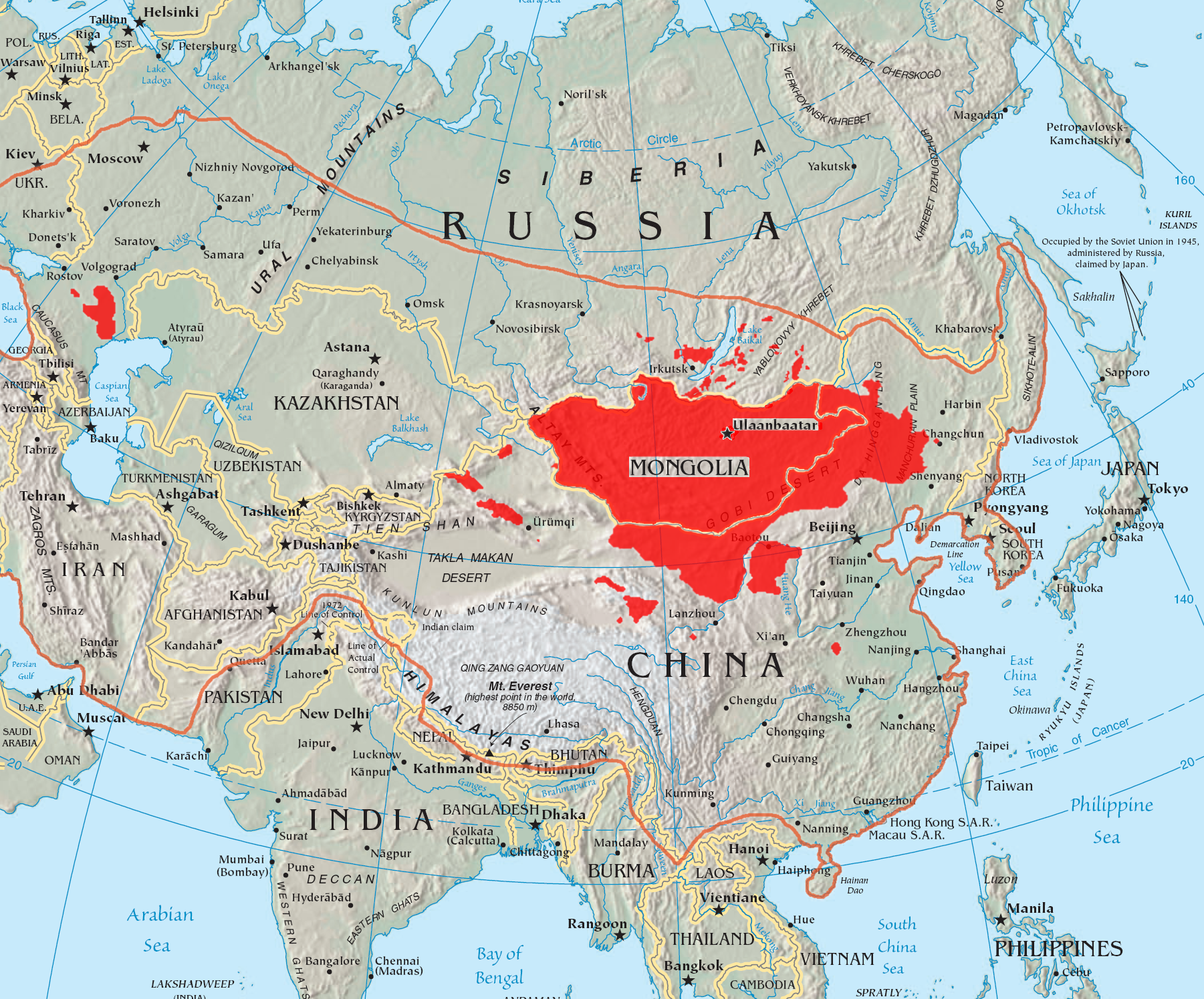
English: A map of the places that Mongol peoples live.
The orange line shows the extent of the Mongol Empire in the late 13th century. The red areas are the places dominated by ethnic Mongols. |
| تریخ | |
| سروت |
|
| لکھاری | Quadell |

|
This linguistic map image could be re-created using vector graphics as an SVG file. This has several advantages; see Commons:Media for cleanup for more information. If an SVG form of this image is available, please upload it and afterwards replace this template with
{{vector version available|new image name}}.
It is recommended to name the SVG file “Mongols-map.svg”—then the template Vector version available (or Vva) does not need the new image name parameter. |
لائسنس –
میں، اس کم دے کاپیرائٹ دا مالک، اس کم نوں اس لائسنس دے مطابق چھاپدا واں:

|
کاپی کرن، ونڈن تے بدلن دی ایس ڈوکومنٹ لئی اجازت دتی جاندی اے ایہناں GNU Free Documentation License, Version 1.2 شرطاں نال یا مگروں کسے وی چھپے ورین Free Software Foundation توں بنا کسے انویرینٹ سیکشن دے، ناں فرنٹ کور لکھت تے ناں بیک کور لکھت دے۔ لسنس دی اک کاپی سیکشن وچ ہیگی اے جہدا ناں اے GNU Free Documentation License۔ |
| ایس فائل نوں کریٹو کامنز Attribution 2.5 پولینڈ لائسنس دتا گیا. | ||
| ||
| اس لائسنس دا ٹیگ GFDL دے مطابق اس فائل چ پایا گیا اے licensing update۔ |
ایس فائل نوں کریٹو کامنز Attribution 2.0 جنرک لائسنس دتا گیا.
- تہانوں کھلھ اے:
- حصہ کرنا – کاپی، ونڈنا تے کم بھیجنا
- فیر رلانا – کم نوں فٹ کرنا
- تھلے دتیاں شرطاں نال:
- کس دے ناں – تسیں لازمی ایس کم دے بناں والے بارے دسو جنج اونے آکھیا اے یا جنج لسنس چ آکھیا گیا ہے۔
- اکو جہا شئیر کرو۔ – اگر تسیں بدلدے یا ایس کم تے بناندے تے بنن والے کم نوں اینج دے لسنس نال ای ونڈو گے۔
تسیں اپنی مرضی دا لائسنس چݨ سکدے اوہ۔
فائل دی تریخ
فائل نو اس ویلے دی حالت وچ ویکھن واسطے تاریخ/ویلے تے کلک کرو۔
| تریخ تے ویلہ | نکی مورت | پاسے | ورتن والا | تیپّݨی کرو | |
|---|---|---|---|---|---|
| موجودہ | ۱۹:۳۷, ۲۹ مئی ۲۰۲۳ | | ۱,۸۰۱ × ۱,۴۹۵ (۲.۷۹ میگابائٹ) | Artanisen | High resolution map with the same borders and areas as version 17:34, 16 July 2005 (UTC) |
| ۰۱:۱۳, ۱۱ اپریل ۲۰۲۱ |  | ۷۲۸ × ۵۲۵ (۲۷۹ کلوبائٹ) | Fæ | Reverted to version as of 17:34, 16 July 2005 (UTC) Untrusted work of sockpuppets | |
| ۰۸:۳۵, ۱۷ جنوری ۲۰۱۹ |  | ۷۲۸ × ۵۲۵ (۲۹۵ کلوبائٹ) | Anchuhu | mongol | |
| ۱۵:۵۶, ۲۲ جون ۲۰۱۷ |  | ۷۲۸ × ۵۲۵ (۶۳۰ کلوبائٹ) | 일성강 | Reverted to version as of 12:47, 1 June 2017 (UTC) | |
| ۱۳:۵۴, ۱۷ جون ۲۰۱۷ |  | ۷۲۸ × ۵۲۵ (۲۷۹ کلوبائٹ) | Calthinus | Reverted to version as of 17:34, 16 July 2005 (UTC) | |
| ۱۷:۴۷, ۱ جون ۲۰۱۷ |  | ۷۲۸ × ۵۲۵ (۶۳۰ کلوبائٹ) | 일성강 | fixed | |
| ۲۲:۳۴, ۱۶ جولائی ۲۰۰۵ |  | ۷۲۸ × ۵۲۵ (۲۷۹ کلوبائٹ) | Hottentot~commonswiki | This is a map of the places that Mongol peoples live. The information is based off of w:en:Image:Mongolsethnic.jpg, and the map I started with is w:en:Image:Asia-map.png. The orange line shows the extent of the Mongol Empire in the late 13th c | |
| ۱۸:۱۴, ۱۶ جولائی ۲۰۰۵ |  | ۷۲۸ × ۵۲۵ (۲۹۷ کلوبائٹ) | Quadell | This is a map of the places that Mongol peoples live. The information is based off of [:w:en:Image:Mongolsethnic.jpg]], and the map I started with is w:en:Image:Asia-map.png. The orange line shows the extent of the Mongol Empire in the late 13th ce |
فائل دی ورتوں
تھلے دتے گئے 2 صفحے اس فائل نال جُڑدے نیں
فائل ویاپک ورتوں
ایہہ دوجے وکیاں ایس فائل نوں ورتدے نیں –
- af.wikipedia.org تے ورتوں
- an.wikipedia.org تے ورتوں
- ar.wikipedia.org تے ورتوں
- arz.wikipedia.org تے ورتوں
- ast.wikipedia.org تے ورتوں
- azb.wikipedia.org تے ورتوں
- ba.wikipedia.org تے ورتوں
- be-tarask.wikipedia.org تے ورتوں
- be.wikipedia.org تے ورتوں
- bg.wiktionary.org تے ورتوں
- bh.wikipedia.org تے ورتوں
- br.wikipedia.org تے ورتوں
- bs.wikipedia.org تے ورتوں
- ca.wikipedia.org تے ورتوں
- ckb.wikipedia.org تے ورتوں
- cs.wikipedia.org تے ورتوں
- cv.wikipedia.org تے ورتوں
- da.wikipedia.org تے ورتوں
- diq.wikipedia.org تے ورتوں
- dsb.wikipedia.org تے ورتوں
- el.wikipedia.org تے ورتوں
- en.wikipedia.org تے ورتوں
ایس فائل دا ویکھو ہور جگت ورتن .