
فائل:Nagaland locator map.svg

Size of this PNG preview of this SVG file: ۷۳۴ × ۶۰۰ پکسلز. دوجے ریزولوشنز: ۲۹۴ × ۲۴۰ پکسلز | ۵۸۷ × ۴۸۰ پکسلز | ۹۴۰ × ۷۶۸ پکسلز | ۱,۲۵۳ × ۱,۰۲۴ پکسلز | ۲,۵۰۶ × ۲,۰۴۸ پکسلز | ۲,۳۹۳ × ۱,۹۵۶ پکسلز ۔
اصل فائل (ایس وی جی فائل، پکسل:۲,۳۹۳ × ۱,۹۵۶، فائل سائز: ۲۷۷ کلوبائٹ)
| سرلیکھ |
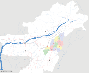
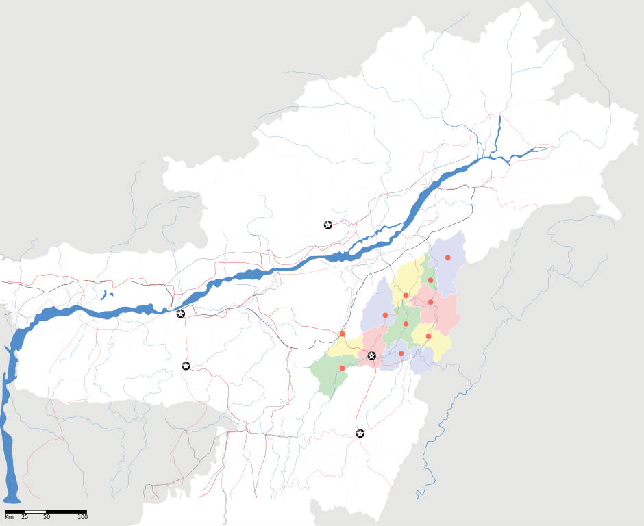
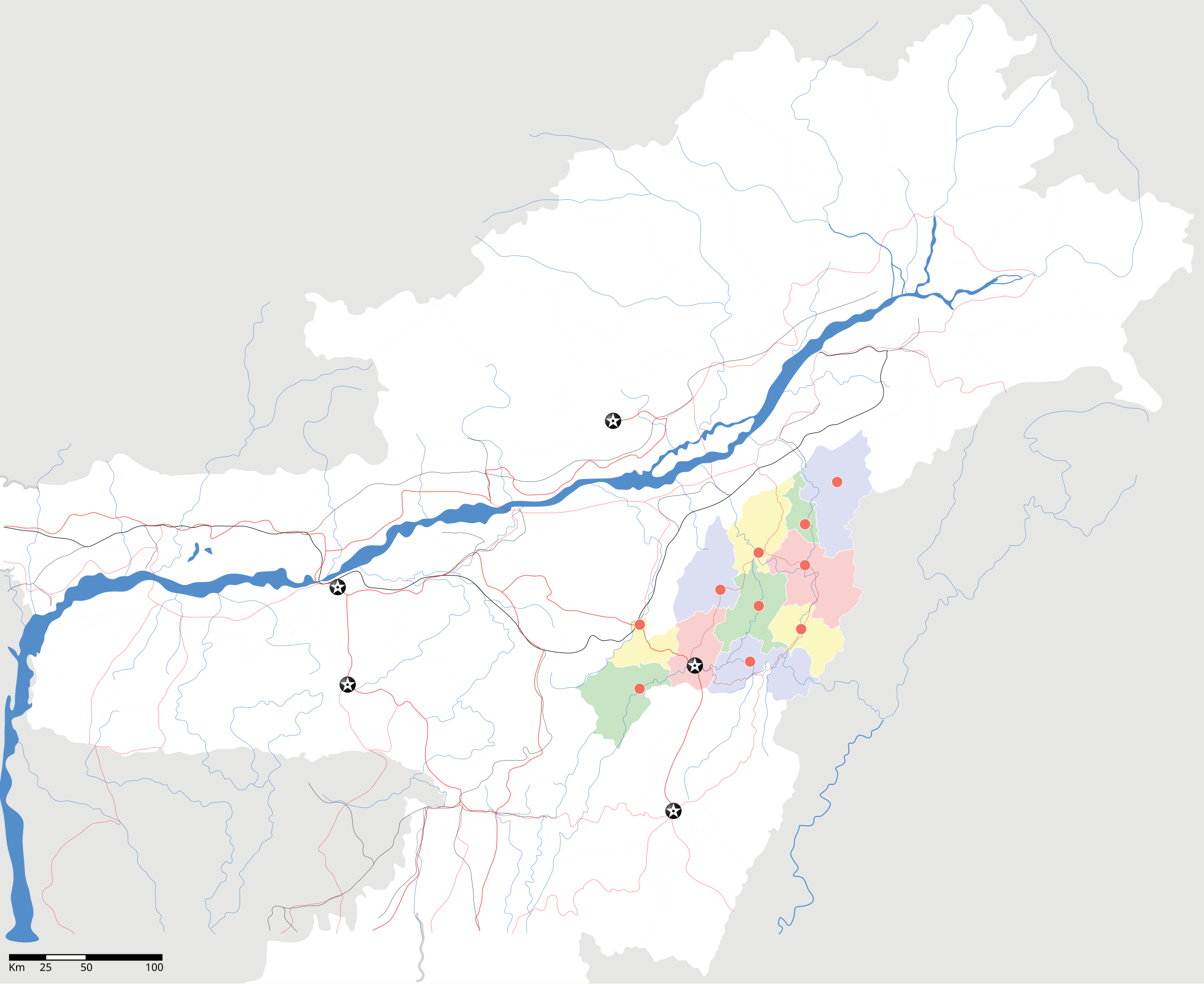
Nagaland locator Map |
| Description |
Map of w:Nagaland with road and rail lines. Equirectangular projection. Geographic limits of the map: top=29.49, bottom=23.74, left=89.61, right=97.52. |
| تریخ | |
| سروت |
آپݨا کم |
| Creator | |
| اجازت (فائل نوں دوبارہ ورتنا) |
میں، اس کم دے کاپیرائٹ دا مالک، اس کم نوں اس لائسنس دے مطابق چھاپدا واں: ایس فائل نوں کریٹو کامنز Attribution 2.5 پولینڈ لائسنس دتا گیا.
|
| Geotemporal data | |
| Date depicted | second half of 20 century تے 21 century |
| Georeferencing | If inappropriate please set warp_status = skip to hide. |
| Archival data | |
| نوٹس | Part of WikiProject India Maps |
فائل دی تریخ
فائل نو اس ویلے دی حالت وچ ویکھن واسطے تاریخ/ویلے تے کلک کرو۔
| تریخ تے ویلہ | نکی مورت | پاسے | ورتن والا | تیپّݨی کرو | |
|---|---|---|---|---|---|
| موجودہ | ۱۷:۰۵, ۱۷ اپریل ۲۰۰۷ | | ۲,۳۹۳ × ۱,۹۵۶ (۲۷۷ کلوبائٹ) | Planemad | not displaying, reupload |
| ۱۷:۰۰, ۱۷ اپریل ۲۰۰۷ |  | ۲,۳۹۳ × ۱,۹۵۶ (۲۷۷ کلوبائٹ) | Planemad | not displaying, reupload | |
| ۱۶:۵۵, ۱۷ اپریل ۲۰۰۷ |  | ۲,۳۹۳ × ۱,۹۵۶ (۲۷۷ کلوبائٹ) | Planemad | {{WikiProject_India_Maps |Title=Nagaland locator Map |Description=Map of w:Nagaland with road and rail lines |Source= [http://www.iitg.ernet.in/rcilts/assam_political.jpg IIT Guwahati - Assam Political map], [http://nagaland.nic.in/planning&coord/p |
فائل دی ورتوں
تھلے دتے گئے 1 صفحے اس فائل نال جُڑدے نیں
فائل ویاپک ورتوں
ایہہ دوجے وکیاں ایس فائل نوں ورتدے نیں –
- ar.wikipedia.org تے ورتوں
- ast.wikipedia.org تے ورتوں
- as.wikipedia.org تے ورتوں
- ba.wikipedia.org تے ورتوں
- bh.wikipedia.org تے ورتوں
- bn.wikipedia.org تے ورتوں
- ceb.wikipedia.org تے ورتوں
- de.wikipedia.org تے ورتوں
- en.wikipedia.org تے ورتوں
- en.wikinews.org تے ورتوں
- es.wikipedia.org تے ورتوں
- fa.wikipedia.org تے ورتوں
- hi.wikipedia.org تے ورتوں
- ja.wikipedia.org تے ورتوں
- kbd.wikipedia.org تے ورتوں
- ml.wikipedia.org تے ورتوں
- nl.wikipedia.org تے ورتوں
- or.wikipedia.org تے ورتوں
- pam.wikipedia.org تے ورتوں
- pa.wikipedia.org تے ورتوں
- sa.wikipedia.org تے ورتوں
- sw.wikipedia.org تے ورتوں
- ta.wikipedia.org تے ورتوں
- tr.wikipedia.org تے ورتوں
- vi.wikipedia.org تے ورتوں
- war.wikipedia.org تے ورتوں
- www.wikidata.org تے ورتوں
- yo.wikipedia.org تے ورتوں
- zh.wikipedia.org تے ورتوں