
فائل:Pyrenees topographic map-fr.svg

Size of this PNG preview of this SVG file: ۸۰۰ × ۴۷۵ پکسلز. دوجے ریزولوشنز: ۳۲۰ × ۱۹۰ پکسلز | ۶۴۰ × ۳۸۰ پکسلز | ۱,۰۲۴ × ۶۰۸ پکسلز | ۱,۲۸۰ × ۷۶۰ پکسلز | ۲,۵۶۰ × ۱,۵۲۰ پکسلز | ۳,۲۰۰ × ۱,۹۰۰ پکسلز ۔
اصل فائل (ایس وی جی فائل، پکسل:۳,۲۰۰ × ۱,۹۰۰، فائل سائز: ۶.۳ میگابائٹ)
![]()
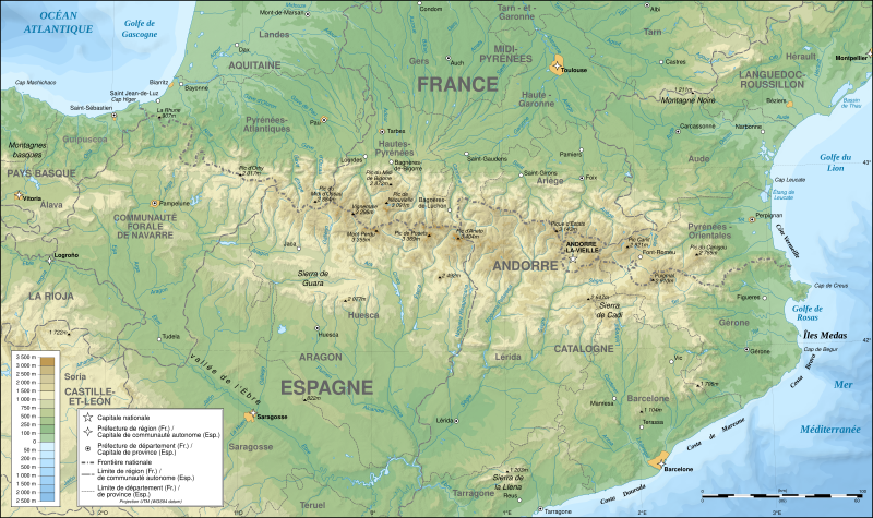
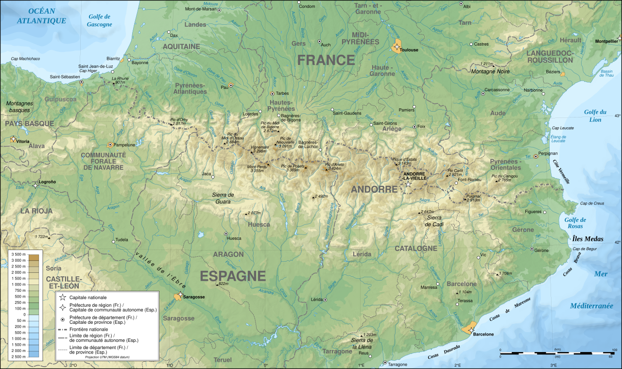
Detailed map of large dimension. For a better viewing, click on the link of the image above.
Carte détaillée de grande dimension. Pour une visualisation optimale, cliquer sur le lien de l'image ci-dessus.
خلاصہ
| Description |
English: Topographic map in French of the Pyrenees mountains.
Note: The shaded relief is a raster image embedded in the SVG file. Français : Carte topographique des Pyrénées en francais.
Note : Le relief ombré est une image bitmap embarquée dans le fichier SVG. Português: Mapa topográfico (em Francês) dos Pirenéus.
Español: Mapa topográfico (en francés) de los Pirineos.
UTM projection; WGS84 datum; shaded relief (composite image of N-W, W and N lightning positions);
|
||
| SVG genesis | |||
| تریخ | May 2007 (modified September 2008) | ||
| سروت |
Own work;
|
||
| Creator | |||
| اجازت (فائل نوں دوبارہ ورتنا) |
|
||
| Georeferencing | If inappropriate please set warp_status = skip to hide. | ||
| دوجے ورژن |
[]
|


Assessment
|

This image was selected as picture of the day on Wikimedia Commons for 1 August 2007. It was captioned as follows: English: Topographic map in French of the Pyrenees mountains. Other languages:
Čeština: Francouzská mapa pohoří Pyreneje Dansk: Topografisk kort over Pyrenæerne på fransk. English: Topographic map in French of the Pyrenees mountains. Français : Carte topographique des Pyrénées en français. Magyar: A Pireneusok térképe Nederlands: Franse Topografische kaart van de Pyreneeën Português: Um mapa topográfico em francês, da região dos Pireneus. Română: Hartă topografică a munților Pirinei, Franța. Suomi: Topografinen kartta Ranskasta, Pyreneiden vuorilta. Svenska: Topografisk karta över Pyrenéerna på franska. Русский: Топографическая карта Пиренеев. Українська: Топографічна карта Піренеїв 中文: 法语注释的比利牛斯山地形图 中文(繁體): 庇里牛斯山的法語地形圖 עברית : מפה טופוגרפית בצרפתית של הרי הפירינאים |
لائسنس –
میں، اس کم دے کاپیرائٹ دا مالک، اس کم نوں اس لائسنس دے مطابق چھاپدا واں:

|
کاپی کرن، ونڈن تے بدلن دی ایس ڈوکومنٹ لئی اجازت دتی جاندی اے ایہناں GNU Free Documentation License, Version 1.2 شرطاں نال یا مگروں کسے وی چھپے ورین Free Software Foundation توں بنا کسے انویرینٹ سیکشن دے، ناں فرنٹ کور لکھت تے ناں بیک کور لکھت دے۔ لسنس دی اک کاپی سیکشن وچ ہیگی اے جہدا ناں اے GNU Free Documentation License۔ |
| ایس فائل نوں کریٹو کامنز Attribution 2.5 پولینڈ لائسنس دتا گیا. | ||
| ||
| اس لائسنس دا ٹیگ GFDL دے مطابق اس فائل چ پایا گیا اے licensing update۔ |
ایس فائل نوں Creative Commons Attribution-Share Alike 2.5 Generic, 2.0 Generic and 1.0 Generic لسنس دتا گیا اے۔
- تہانوں کھلھ اے:
- حصہ کرنا – کاپی، ونڈنا تے کم بھیجنا
- فیر رلانا – کم نوں فٹ کرنا
- تھلے دتیاں شرطاں نال:
- کس دے ناں – تسیں لازمی ایس کم دے بناں والے بارے دسو جنج اونے آکھیا اے یا جنج لسنس چ آکھیا گیا ہے۔
- اکو جہا شئیر کرو۔ – اگر تسیں بدلدے یا ایس کم تے بناندے تے بنن والے کم نوں اینج دے لسنس نال ای ونڈو گے۔
تسیں اپنی مرضی دا لائسنس چݨ سکدے اوہ۔
فائل دی تریخ
فائل نو اس ویلے دی حالت وچ ویکھن واسطے تاریخ/ویلے تے کلک کرو۔
| تریخ تے ویلہ | نکی مورت | پاسے | ورتن والا | تیپّݨی کرو | |
|---|---|---|---|---|---|
| موجودہ | ۰۵:۰۵, ۱۴ دسمبر ۲۰۱۲ | | ۳,۲۰۰ × ۱,۹۰۰ (۶.۳ میگابائٹ) | Benh | uses Helvetica over Arial when available. |
| ۲۰:۴۹, ۲۳ ستمبر ۲۰۰۸ |  | ۳,۲۰۰ × ۱,۹۰۰ (۶.۳ میگابائٹ) | Sting | Using ETOPO1 data for bathymetry; new standard colors | |
| ۰۵:۲۵, ۲ جولائی ۲۰۰۷ |  | ۳,۲۰۰ × ۱,۹۰۰ (۵.۹ میگابائٹ) | Sting | + projection info in key ; + major cities areas ; some corrections in the rivers | |
| ۰۱:۳۰, ۲۶ جون ۲۰۰۷ |  | ۳,۲۰۰ × ۱,۹۰۰ (۵.۸۸ میگابائٹ) | Sting | + key for borders | |
| ۰۲:۱۸, ۱ جون ۲۰۰۷ |  | ۳,۲۰۰ × ۱,۹۰۰ (۵.۸۸ میگابائٹ) | Sting | Some corrections | |
| ۲۳:۲۳, ۳۰ مئی ۲۰۰۷ |  | ۳,۲۰۰ × ۱,۹۰۰ (۵.۸۸ میگابائٹ) | Sting | {{Information |Description=Topographic map in French of the Pyrenees mountains |Source=Own work ;<br/>Topographic map : [http://www2.jpl.nasa.gov/srtm NASA Shuttle Radar Topography Mission] (SRTM3 v.2) (public domain) edited with [http:// |
فائل دی ورتوں
اس فائل نال جڑیا کوئی صفحہ نئیں۔
فائل ویاپک ورتوں
ایہہ دوجے وکیاں ایس فائل نوں ورتدے نیں –
- af.wikipedia.org تے ورتوں
- an.wikipedia.org تے ورتوں
- ar.wikipedia.org تے ورتوں
- azb.wikipedia.org تے ورتوں
- ba.wikipedia.org تے ورتوں
- bs.wikipedia.org تے ورتوں
- ca.wikipedia.org تے ورتوں
- cs.wikipedia.org تے ورتوں
- en.wikipedia.org تے ورتوں
- eo.wikipedia.org تے ورتوں
- es.wikipedia.org تے ورتوں
- et.wikipedia.org تے ورتوں
- eu.wikipedia.org تے ورتوں
- fa.wikipedia.org تے ورتوں
- fi.wikipedia.org تے ورتوں
- fr.wikipedia.org تے ورتوں
- Ariège (département)
- Aude (département)
- Andorre
- Sentier de grande randonnée 10
- Haute-Garonne
- Hautes-Pyrénées
- Pyrénées-Orientales
- Pyrénées
- Liste des communes des Hautes-Pyrénées
- Discussion:Liste des communes des Hautes-Pyrénées
- Pau
- Béarn
- Bayonne
- Tarbes
- Adour
- Ariège (rivière)
- Vals (Ariège)
- Catalogne
- Aragon (communauté autonome)
- Huesca
- Bizanos
- Pays basque
- Discussion:Béarn
- Discussion:Pau
- Val d'Aran
- Prades (Pyrénées-Orientales)
- Haute-Navarre
- Lugdunum Convenarum
- Lourdes
ایس فائل دا ویکھو ہور جگت ورتن .