
فائل:Somaliland map.png
اس توں وڈی مورت موجود نہیں۔
Somaliland_map.png (۸۰۰ × ۵۰۴ پکسلز, فائل حجم: ۹۹ کلوبائٹ, MIME type: image/png)
خلاصہ
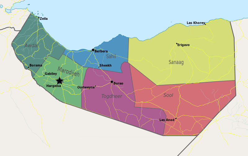
| تفصیل | Map of Somaliland. |
| تریخ | |
| سروت | آپݨا کم |
| لکھاری | PANONIAN |
لائسنس –
میں، اس کم دے کاپیرائٹ دا مالک، اس کم نوں اس لائسنس دے مطابق چھاپدا واں:
| ایس فائل نوں ایہ لسنس کریٹو کامنز CC0 1.0 یونیورسل پبلک ڈومین ڈیڈیکیشن دتا گیا اے۔ | |
| اوہ بندا جینے اے کم کیتا اے اونے اے کم public domain دے ناں لایا اے تے سارے حقاں نوں چھڈ دتا اے۔ تسیں اینو کاروبار کم لئی ورت سکدے اے یا بدل سکدے او بنا کسے اجازت دے۔
|
References
- http://www.sdo.nu/wp-content/uploads/2010/04/map-vd-steden1.gif
- http://www.somaliland.org/images/i/map_somaliland_org.gif
- http://www.somaliland.org/images/b/2007/11/map_somaliland.gif
- http://images.wikia.com/turtledove/images/c/c7/SomalilandMap.jpg
- http://xarbi.files.wordpress.com/2010/11/somaliland-map-in-ai.jpg
- http://cdn-english.alshahid.net/wp-content/uploads/2010/02/somland.jpg?59dea9
- http://www.tothepointnews.com/images/stories/2011/somaliland_map.jpg
- http://xarbi.files.wordpress.com/2010/04/somaliland-map22.jpg
- http://xarbi.files.wordpress.com/2010/05/somaliland-map-20101.jpg
- http://www.afrol.com/images/maps/somaliland_big.gif
فائل دی تریخ
فائل نو اس ویلے دی حالت وچ ویکھن واسطے تاریخ/ویلے تے کلک کرو۔
| تریخ تے ویلہ | نکی مورت | پاسے | ورتن والا | تیپّݨی کرو | |
|---|---|---|---|---|---|
| موجودہ | ۱۶:۵۵, ۱۰ مئی ۲۰۲۱ | | ۸۰۰ × ۵۰۴ (۹۹ کلوبائٹ) | Siirski | Update |
| ۲۳:۰۴, ۲۰ جون ۲۰۲۰ |  | ۱,۲۵۴ × ۷۴۱ (۴۲ کلوبائٹ) | Chipmunkdavis | Reverted to version as of 14:41, 2 July 2012 (UTC) Rv unlablled change. The only labelled place is controlled by Somaliland. | |
| ۰۱:۳۱, ۱۸ جون ۲۰۲۰ |  | ۸۰۰ × ۴۷۳ (۶۴ کلوبائٹ) | Meelpringthusss | clearer color | |
| ۰۷:۱۲, ۱۶ جون ۲۰۲۰ |  | ۸۰۰ × ۴۷۳ (۶۴ کلوبائٹ) | Meelpringthusss | added disputed areas | |
| ۱۹:۴۱, ۲ جولائی ۲۰۱۲ |  | ۱,۲۵۴ × ۷۴۱ (۴۲ کلوبائٹ) | PANONIAN | {{Information |Description=Map of Somaliland. |Source={{own}} |Date=2012 |Author= PANONIAN |Permission= |other_versions= }} |
فائل دی ورتوں
تھلے دتے گئے 1 صفحے اس فائل نال جُڑدے نیں
فائل ویاپک ورتوں
ایہہ دوجے وکیاں ایس فائل نوں ورتدے نیں –
- arz.wikipedia.org تے ورتوں
- be.wikipedia.org تے ورتوں
- bn.wikipedia.org تے ورتوں
- bs.wikipedia.org تے ورتوں
- ca.wikipedia.org تے ورتوں
- crh.wikipedia.org تے ورتوں
- dv.wikipedia.org تے ورتوں
- ga.wikipedia.org تے ورتوں
- hr.wikipedia.org تے ورتوں
- hy.wikipedia.org تے ورتوں
- incubator.wikimedia.org تے ورتوں
- ms.wikipedia.org تے ورتوں
- oc.wikipedia.org تے ورتوں
- pam.wikipedia.org تے ورتوں
- sa.wikipedia.org تے ورتوں
- sco.wikipedia.org تے ورتوں
- sh.wikipedia.org تے ورتوں
- sk.wikipedia.org تے ورتوں
- so.wikipedia.org تے ورتوں
- sr.wikipedia.org تے ورتوں
- su.wikipedia.org تے ورتوں
- ta.wikipedia.org تے ورتوں
- tl.wikipedia.org تے ورتوں
- tr.wikipedia.org تے ورتوں
- ur.wikipedia.org تے ورتوں
- xmf.wikipedia.org تے ورتوں