
فائل:Tripura map.png
ایس وکھالے دا ناپ: ۴۱۳ × ۵۹۹ پکسلز۔ دوجے ریزولوشنز: ۱۶۵ × ۲۴۰ پکسلز | ۳۳۱ × ۴۸۰ پکسلز | ۸۹۹ × ۱,۳۰۴ پکسلز ۔
اصل فائل (۸۹۹ × ۱,۳۰۴ پکسلز, فائل حجم: ۱۶۴ کلوبائٹ, MIME type: image/png)

|
This locator map image could be re-created using vector graphics as an SVG file. This has several advantages; see Commons:Media for cleanup for more information. If an SVG form of this image is available, please upload it and afterwards replace this template with
{{vector version available|new image name}}.
It is recommended to name the SVG file “Tripura map.svg”—then the template Vector version available (or Vva) does not need the new image name parameter. |
خلاصہ
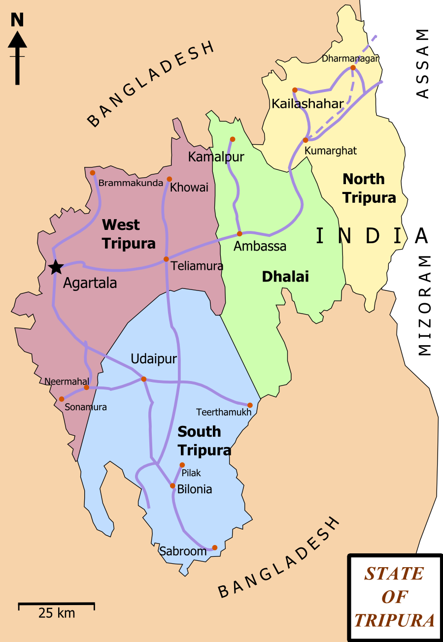
| تفصیل | Map of State of Tripura. The map shows the former 4 districts of Tripura, with the state's roads and railway networks detailed. Railway was extended upto Agartala from Kumbarghat and opened by 2008.[1] |
| تریخ | |
| سروت | آپݨا کم |
| لکھاری | Wikigringo |
| اجازت (فائل نوں دوبارہ ورتنا) |
attribution to author. |
| دوجے ورژن | Tripura locator map blank.svg.png |
| سرلیکھ |
Tripura locator map |
| Description |
Locator map of the state of Tripura, India with district boundaries. |
| تریخ | |
| سروت |
آپݨا کم |
| Creator | |
| اجازت (فائل نوں دوبارہ ورتنا) |
میں، اس کم دے کاپیرائٹ دا مالک، اس کم نوں اس لائسنس دے مطابق چھاپدا واں: ایس فائل نوں کریٹو کامنز Attribution 2.5 پولینڈ لائسنس دتا گیا.
|
| Geotemporal data | |
| Date depicted | second half of 20 century تے 21 century |
| Georeferencing | If inappropriate please set warp_status = skip to hide. |
| Archival data | |
| نوٹس | Part of WikiProject India Maps |
لائسنس –
میں، اس کم دے کاپیرائٹ دا مالک، اس کم نوں اس لائسنس دے مطابق چھاپدا واں:

|
کاپی کرن، ونڈن تے بدلن دی ایس ڈوکومنٹ لئی اجازت دتی جاندی اے ایہناں GNU Free Documentation License, Version 1.2 شرطاں نال یا مگروں کسے وی چھپے ورین Free Software Foundation توں بنا کسے انویرینٹ سیکشن دے، ناں فرنٹ کور لکھت تے ناں بیک کور لکھت دے۔ لسنس دی اک کاپی سیکشن وچ ہیگی اے جہدا ناں اے GNU Free Documentation License۔ |
This file is licensed under the Creative Commons Attribution-Share Alike 4.0 International, 3.0 Unported, 2.5 Generic, 2.0 Generic and 1.0 Generic license.
- تہانوں کھلھ اے:
- حصہ کرنا – کاپی، ونڈنا تے کم بھیجنا
- فیر رلانا – کم نوں فٹ کرنا
- تھلے دتیاں شرطاں نال:
- کس دے ناں – تسیں لازمی ایس کم دے بناں والے بارے دسو جنج اونے آکھیا اے یا جنج لسنس چ آکھیا گیا ہے۔
- اکو جہا شئیر کرو۔ – اگر تسیں بدلدے یا ایس کم تے بناندے تے بنن والے کم نوں اینج دے لسنس نال ای ونڈو گے۔
تسیں اپنی مرضی دا لائسنس چݨ سکدے اوہ۔
فائل دی تریخ
فائل نو اس ویلے دی حالت وچ ویکھن واسطے تاریخ/ویلے تے کلک کرو۔
| تریخ تے ویلہ | نکی مورت | پاسے | ورتن والا | تیپّݨی کرو | |
|---|---|---|---|---|---|
| موجودہ | ۲۲:۰۶, ۱۵ فروری ۲۰۱۲ | | ۸۹۹ × ۱,۳۰۴ (۱۶۴ کلوبائٹ) | Ras67 | cropped and optimized |
| ۱۸:۱۵, ۲۷ فروری ۲۰۰۸ |  | ۹۲۱ × ۱,۳۲۶ (۲۲۹ کلوبائٹ) | Wikigringo | {{Information |Description=Map of State of Tripura. Map shows the 4 districts of Tripura along with roadways and small railway network present in the state. |Source=self-made |Date=02/27/2008 |Author= Wikigringo |Permission=attribution |
فائل دی ورتوں
تھلے دتے گئے 2 صفحے اس فائل نال جُڑدے نیں
فائل ویاپک ورتوں
ایہہ دوجے وکیاں ایس فائل نوں ورتدے نیں –
- as.wikipedia.org تے ورتوں
- bn.wikipedia.org تے ورتوں
- ধর্মনগর
- কমলপুর
- ত্রিপুরা বিধানসভা নির্বাচন, ২০১৩
- ত্রিপুরা বিধানসভা নির্বাচন, ২০০৮
- ত্রিপুরা বিধানসভা নির্বাচন, ২০০৩
- ত্রিপুরা বিধানসভা নির্বাচন, ১৯৭২
- ত্রিপুরা বিধানসভা নির্বাচন, ১৯৭৭
- ত্রিপুরা বিধানসভা নির্বাচন, ১৯৮৩
- ত্রিপুরা বিধানসভা নির্বাচন, ১৯৮৮
- ত্রিপুরা বিধানসভা নির্বাচন, ১৯৯৩
- ত্রিপুরা বিধানসভা নির্বাচন, ১৯৯৮
- ca.wikipedia.org تے ورتوں
- en.wikipedia.org تے ورتوں
- Portal:India/Selected picture candidates
- Belonia, India
- User:Gppande/Album
- Portal:India/Selected picture candidates/Tripura district map
- 2008 Tripura Legislative Assembly election
- 2013 Tripura Legislative Assembly election
- Wikipedia:Graphics Lab/Map workshop/Archive/Apr 2013
- Santirbazar
- 2003 Tripura Legislative Assembly election
- 1998 Tripura Legislative Assembly election
- 1993 Tripura Legislative Assembly election
- 1988 Tripura Legislative Assembly election
- 1983 Tripura Legislative Assembly election
- 1977 Tripura Legislative Assembly election
- 1972 Tripura Legislative Assembly election
- eu.wikipedia.org تے ورتوں
- fa.wikipedia.org تے ورتوں
- gom.wikipedia.org تے ورتوں
- hi.wikipedia.org تے ورتوں
- hr.wikipedia.org تے ورتوں
- incubator.wikimedia.org تے ورتوں
- kk.wikipedia.org تے ورتوں
- ml.wikipedia.org تے ورتوں
- ne.wikipedia.org تے ورتوں
- new.wikipedia.org تے ورتوں
ایس فائل دا ویکھو ہور جگت ورتن .