
فائل:Wright Brothers Memorial-27527-1.JPG

ایس وکھالے دا ناپ: ۶۰۰ × ۶۰۰ پکسلز۔ دوجے ریزولوشنز: ۲۴۰ × ۲۴۰ پکسلز | ۴۸۰ × ۴۸۰ پکسلز | ۷۶۸ × ۷۶۸ پکسلز | ۱,۰۲۴ × ۱,۰۲۴ پکسلز | ۱,۶۰۰ × ۱,۶۰۰ پکسلز ۔
اصل فائل (۱,۶۰۰ × ۱,۶۰۰ پکسلز, فائل حجم: ۵۴۵ کلوبائٹ, MIME type: image/jpeg)
خلاصہ
| تفصیل |
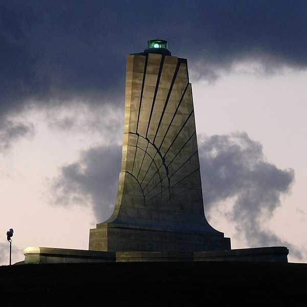
Standing sixty feet (18.3 meters) tall and perched atop a ninety foot (27.4 meters) stabilized sand dune known as Kill Devil Hill, this monument towers over Wright Brothers National Memorial Park in Kill Devil Hills, NC. The park commemorates and preserves the site where the Wright brothers launched the world's first successful sustained, powered flights in a heavier-than-air machine. The inscription that wraps around the base of the monument states "In commemoration of the conquest of the air by the brothers Wilbur and Orville Wright. Conceived by genius, achieved by dauntless resolution and unconquerable faith." Photo taken with a Panasonic Lumix DMC-FZ50 in Dare County, NC, USA. |
| تریخ | ۱۹ اکتوبر ۲۰۰۸, ۰۶:۵۶ −۰۴:۰۰ |
| سروت |
KenThomas.us (personal website of photographer) |
| لکھاری | Ken Thomas |
| اجازت (فائل نوں دوبارہ ورتنا) |
This image is released to the public domain, and therefore no permission or credit is required. Comments and/or feedback however, are always welcome. See my user page for contact info. |
| دوجے ورژن |
|

لائسنس –
| میں، اس کم دے کاپیرائٹ دا مالک، اس کم نوں لوکاں واسطے دیندا واں۔ اے سارے جگ واسطے لاگو اے۔ کج ملکاں چ قانونی طور تے اے ممکن نئیں اے؛ اگر انج ای اے ے: میں ہر کسے نوں اس کم نوں کسے وی مقصد واسطے ورتن دا بغیر کسے شرط دے حق دیندا واں، اگر اوہ قانون دے خلاف نا ہوۓ۔ |
| Camera location | | View this and other nearby images on: OpenStreetMap |
|---|
فائل دی تریخ
فائل نو اس ویلے دی حالت وچ ویکھن واسطے تاریخ/ویلے تے کلک کرو۔
| تریخ تے ویلہ | نکی مورت | پاسے | ورتن والا | تیپّݨی کرو | |
|---|---|---|---|---|---|
| موجودہ | ۲۰:۱۸, ۲۰ اکتوبر ۲۰۰۸ | | ۱,۶۰۰ × ۱,۶۰۰ (۵۴۵ کلوبائٹ) | Ken Thomas | {{Information |Description=Standing sixty feet (18.3 meters) tall and perched atop a ninety foot (27.4 meters) stabilized sand dune known as Kill Devil Hill, this monument towers o |
فائل دی ورتوں
تھلے دتے گئے 1 صفحے اس فائل نال جُڑدے نیں
فائل ویاپک ورتوں
ایہہ دوجے وکیاں ایس فائل نوں ورتدے نیں –
- ast.wikipedia.org تے ورتوں
- ca.wikipedia.org تے ورتوں
- ceb.wikipedia.org تے ورتوں
- cs.wikipedia.org تے ورتوں
- de.wikipedia.org تے ورتوں
- en.wikipedia.org تے ورتوں
- en.wikivoyage.org تے ورتوں
- eo.wikipedia.org تے ورتوں
- es.wikipedia.org تے ورتوں
- fa.wikipedia.org تے ورتوں
- fi.wikipedia.org تے ورتوں
- fr.wikipedia.org تے ورتوں
- hr.wikipedia.org تے ورتوں
- it.wikipedia.org تے ورتوں
- ja.wikipedia.org تے ورتوں
- nn.wikipedia.org تے ورتوں
- no.wikipedia.org تے ورتوں
- pt.wikipedia.org تے ورتوں
- ru.wikipedia.org تے ورتوں
- www.wikidata.org تے ورتوں
- zh.wikipedia.org تے ورتوں