
فائل:The development of the German linguistic area.gif
ایس وکھالے دا ناپ: ۸۰۰ × ۵۰۴ پکسلز۔ دوجے ریزولوشنز: ۳۲۰ × ۲۰۲ پکسلز | ۶۴۰ × ۴۰۳ پکسلز | ۱,۰۳۱ × ۶۵۰ پکسلز ۔
اصل فائل (۱,۰۳۱ × ۶۵۰ پکسلز, فائل حجم: ۱۶۰ کلوبائٹ, MIME type: image/gif، لوپڈ، ۵ فریمز، ۵.۰ سیکنڈ)

خلاصہ
| تفصیل |
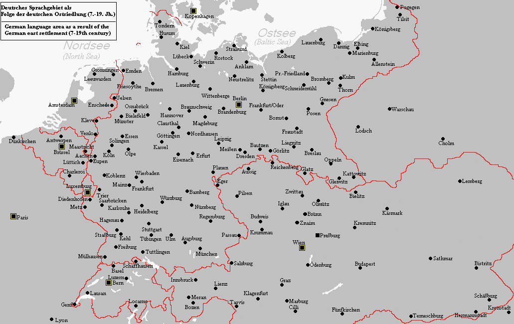
English: The map shows the development of the German linguistic area from around 1000 to modern times. |
| سروت | آپݨا کم |
| لکھاری | Postmann Michael |
لائسنس –
میں، اس کم دے کاپیرائٹ دا مالک، اس کم نوں اس لائسنس دے مطابق چھاپدا واں:

|
کاپی کرن، ونڈن تے بدلن دی ایس ڈوکومنٹ لئی اجازت دتی جاندی اے ایہناں GNU Free Documentation License, Version 1.2 شرطاں نال یا مگروں کسے وی چھپے ورین Free Software Foundation توں بنا کسے انویرینٹ سیکشن دے، ناں فرنٹ کور لکھت تے ناں بیک کور لکھت دے۔ لسنس دی اک کاپی سیکشن وچ ہیگی اے جہدا ناں اے GNU Free Documentation License۔ |
| ایس فائل نوں کریٹو کامنز Attribution 2.5 پولینڈ لائسنس دتا گیا. | ||
| ||
| اس لائسنس دا ٹیگ GFDL دے مطابق اس فائل چ پایا گیا اے licensing update۔ |
ایس فائل نوں Creative Commons Attribution-Share Alike 2.5 Generic, 2.0 Generic and 1.0 Generic لسنس دتا گیا اے۔
- تہانوں کھلھ اے:
- حصہ کرنا – کاپی، ونڈنا تے کم بھیجنا
- فیر رلانا – کم نوں فٹ کرنا
- تھلے دتیاں شرطاں نال:
- کس دے ناں – تسیں لازمی ایس کم دے بناں والے بارے دسو جنج اونے آکھیا اے یا جنج لسنس چ آکھیا گیا ہے۔
- اکو جہا شئیر کرو۔ – اگر تسیں بدلدے یا ایس کم تے بناندے تے بنن والے کم نوں اینج دے لسنس نال ای ونڈو گے۔
تسیں اپنی مرضی دا لائسنس چݨ سکدے اوہ۔
فائل دی تریخ
فائل نو اس ویلے دی حالت وچ ویکھن واسطے تاریخ/ویلے تے کلک کرو۔
| تریخ تے ویلہ | نکی مورت | پاسے | ورتن والا | تیپّݨی کرو | |
|---|---|---|---|---|---|
| موجودہ | ۱۶:۱۶, ۱۵ ستمبر ۲۰۱۰ | | ۱,۰۳۱ × ۶۵۰ (۱۶۰ کلوبائٹ) | Wester | Reverted to version as of 08:50, 13 December 2006 |
| ۰۱:۵۶, ۲۶ جنوری ۲۰۰۷ |  | ۱,۲۴۸ × ۱,۴۷۲ (۲.۰۷ میگابائٹ) | Postmann Michael~commonswiki | Revise. A more detailed map description soon follows. | |
| ۰۴:۳۱, ۱۵ دسمبر ۲۰۰۶ |  | ۱,۴۷۲ × ۱,۴۷۲ (۵۷۱ کلوبائٹ) | Postmann Michael~commonswiki | This map shows the development of the German linguistic area as a result of the so-called "German east settlement". This contained the period of time for 12th to 14th century and contained about 500,000 people. The first settlers were predominantly "North | |
| ۱۳:۵۰, ۱۳ دسمبر ۲۰۰۶ |  | ۱,۰۳۱ × ۶۵۰ (۱۶۰ کلوبائٹ) | Postmann Michael~commonswiki | The map shows the emergence of the German linguistic area in the course of the so-called "German east settlement" in the period of time of 7 until the 19th century. This map was done by me. |
فائل دی ورتوں
تھلے دتے گئے 1 صفحے اس فائل نال جُڑدے نیں
فائل ویاپک ورتوں
ایہہ دوجے وکیاں ایس فائل نوں ورتدے نیں –
- ar.wikipedia.org تے ورتوں
- az.wikipedia.org تے ورتوں
- cs.wikipedia.org تے ورتوں
- de.wikipedia.org تے ورتوں
- en.wikipedia.org تے ورتوں
- eo.wikipedia.org تے ورتوں
- es.wikipedia.org تے ورتوں
- eu.wikipedia.org تے ورتوں
- gl.wikipedia.org تے ورتوں
- hr.wikipedia.org تے ورتوں
- hu.wikipedia.org تے ورتوں
- it.wikipedia.org تے ورتوں
- ja.wikipedia.org تے ورتوں
- lfn.wikipedia.org تے ورتوں
- lt.wikipedia.org تے ورتوں
- pt.wikipedia.org تے ورتوں
- ro.wikipedia.org تے ورتوں
- sl.wikipedia.org تے ورتوں
- sr.wikipedia.org تے ورتوں
- tr.wikipedia.org تے ورتوں
- uk.wikipedia.org تے ورتوں
- www.wikidata.org تے ورتوں