
فائل:1873 Stieler Map of Asia Minor, Syria and Israel - Palestine (modern Turkey) - Geographicus - Klein-AsienSyrien-stieler-1873.jpg

ایس وکھالے دا ناپ: ۷۳۳ × ۵۹۹ پکسلز۔ دوجے ریزولوشنز: ۲۹۴ × ۲۴۰ پکسلز | ۵۸۷ × ۴۸۰ پکسلز | ۹۴۰ × ۷۶۸ پکسلز | ۱,۲۵۳ × ۱,۰۲۴ پکسلز | ۲,۵۰۵ × ۲,۰۴۸ پکسلز | ۴,۰۰۰ × ۳,۲۷۰ پکسلز ۔
اصل فائل (۴,۰۰۰ × ۳,۲۷۰ پکسلز, فائل حجم: ۳.۷۹ میگابائٹ, MIME type: image/jpeg)
| Justus Perthes: Klein-Asien & Syrien nebst Den Westlichen Theilen von Armenien, Kurdistan & Mesopotamien.
( |
|||||||||||||||||||||||||||
|---|---|---|---|---|---|---|---|---|---|---|---|---|---|---|---|---|---|---|---|---|---|---|---|---|---|---|---|
| آرٹسٹ |
|
||||||||||||||||||||||||||
| سرخی |
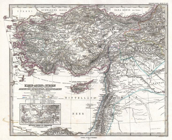
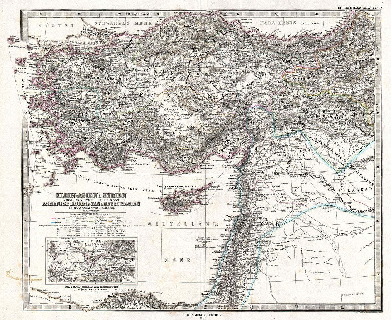
Klein-Asien & Syrien nebst Den Westlichen Theilen von Armenien, Kurdistan & Mesopotamien. |
||||||||||||||||||||||||||
| تفصیل |
English: This is a beautiful example of Stieler’s 1873 map of the modern day Turkey, Syria, Israel / Palestine and Cyprus. Highly detailed with both political and physical data. Shows cities, mountains, roads, rivers and local divisions. An inset in the lower left quadrant features the vicinity of Smyrna (modern Ismir), including depth sounding in the Gulf of Smyrna and harbor. Printed to a high production standard, as was typical of German and especially Perthes/Stieler maps of this period. Published by the Justus Perthes firm and engraved by F. Eulenstein and C. Jungmann for issue as plate no. 43 in the 1873 edition of Stieler’s Hand-Atlas . |
||||||||||||||||||||||||||
| تریخ | ۱۸۷۳ (dated) | ||||||||||||||||||||||||||
| ڈائمنشن | height: ۱۳.۵ in (۳۴.۲ cm)؛ width: ۱۶.۶ in (۴۲.۱ cm) | ||||||||||||||||||||||||||
| ملن نمبر |
Geographicus link: Klein-AsienSyrien-stieler-1873 |
||||||||||||||||||||||||||
| ذریعہ/فوٹوگرافر |
Stieler's Hand-Atlas (1873 issue).
|
||||||||||||||||||||||||||
| اجازت (فائل نوں دوبارہ ورتنا) |
|
||||||||||||||||||||||||||

_-_Geographicus_-_Klein-AsienSyrien-stieler-1873.jpg)
فائل دی تریخ
فائل نو اس ویلے دی حالت وچ ویکھن واسطے تاریخ/ویلے تے کلک کرو۔
| تریخ تے ویلہ | نکی مورت | پاسے | ورتن والا | تیپّݨی کرو | |
|---|---|---|---|---|---|
| موجودہ | ۱۳:۰۲, ۱۸ مارچ ۲۰۱۱ | | ۴,۰۰۰ × ۳,۲۷۰ (۳.۷۹ میگابائٹ) | BotMultichill | {{subst:User:Multichill/Geographicus |link=http://www.geographicus.com/P/AntiqueMap/Klein-AsienSyrien-stieler-1873 |product_name=1873 Stieler Map of Asia Minor, Syria and Israel - Palestine (modern Turkey) |map_title=Klein-Asien & Syrien nebst Den Westlic |
فائل دی ورتوں
تھلے دتے گئے 1 صفحے اس فائل نال جُڑدے نیں
فائل ویاپک ورتوں
ایہہ دوجے وکیاں ایس فائل نوں ورتدے نیں –
- ar.wikipedia.org تے ورتوں
- az.wikipedia.org تے ورتوں
- bn.wikipedia.org تے ورتوں
- en.wikipedia.org تے ورتوں
- eo.wikipedia.org تے ورتوں
- it.wikipedia.org تے ورتوں
- ko.wikipedia.org تے ورتوں
- mk.wikipedia.org تے ورتوں
- mt.wikipedia.org تے ورتوں
- sl.wikipedia.org تے ورتوں
- tr.wikipedia.org تے ورتوں
- ur.wikipedia.org تے ورتوں
_-_Geographicus_-_Klein-AsienSyrien-stieler-1873.jpg)