
فائل:476eur.jpg
اس توں وڈی مورت موجود نہیں۔
476eur.jpg (۶۲۰ × ۴۱۱ پکسلز, فائل حجم: ۲۲۱ کلوبائٹ, MIME type: image/jpeg)
خلاصہ
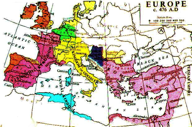
{{ew|en|Durova}] Europe in 476 AD, from Muir's Historical Atlas. (1911) Uploaded from Fordham University [1].
![[1]](http://www.fordham.edu/halsall/maps/476eur.jpg)
_en.png)
.png)
.jpg)
لائسنس –
This media file is in the public domain in the United States. This applies to U.S. works where the copyright has expired, often because its first publication occurred prior to January 1, 1929, and if not then due to lack of notice or renewal. See this page for further explanation.
|
 | |
 |
This image might not be in the public domain outside of the United States; this especially applies in the countries and areas that do not apply the rule of the shorter term for US works, such as Canada, Mainland China (not Hong Kong or Macao), Germany, Mexico, and Switzerland. The creator and year of publication are essential information and must be provided. See Wikipedia:Public domain and Wikipedia:Copyrights for more details.
|
فائل دی تریخ
فائل نو اس ویلے دی حالت وچ ویکھن واسطے تاریخ/ویلے تے کلک کرو۔
| تریخ تے ویلہ | نکی مورت | پاسے | ورتن والا | تیپّݨی کرو | |
|---|---|---|---|---|---|
| موجودہ | ۲۱:۰۹, ۱۶ نومبر ۲۰۲۲ | | ۶۲۰ × ۴۱۱ (۲۲۱ کلوبائٹ) | Gyalu22 | I'm going blind |
| ۱۸:۲۱, ۲۰ مارچ ۲۰۱۷ |  | ۶۲۰ × ۴۱۱ (۲۶۸ کلوبائٹ) | Julieta39 | contrast | |
| ۱۹:۰۴, ۳ دسمبر ۲۰۰۶ |  | ۶۲۰ × ۴۱۱ (۷۱ کلوبائٹ) | Electionworld | {{ew|en|Durova}] Europe in 476 AD, from ''Muir's Historical Atlas.'' (1911) Uploaded from Fordham University [http://www.fordham.edu/halsall/maps/476eur.jpg]. == Licensing == {{PD-US}} Category:Maps of the history of Europe |
فائل دی ورتوں
تھلے دتے گئے 1 صفحے اس فائل نال جُڑدے نیں
فائل ویاپک ورتوں
ایہہ دوجے وکیاں ایس فائل نوں ورتدے نیں –
- bg.wikipedia.org تے ورتوں
- ca.wikipedia.org تے ورتوں
- en.wikipedia.org تے ورتوں
- eo.wikipedia.org تے ورتوں
- es.wikipedia.org تے ورتوں
- fr.wikipedia.org تے ورتوں
- he.wikipedia.org تے ورتوں
- hy.wikipedia.org تے ورتوں
- it.wikipedia.org تے ورتوں
- it.wikibooks.org تے ورتوں
- nl.wikipedia.org تے ورتوں
- ru.wikipedia.org تے ورتوں
- sr.wikipedia.org تے ورتوں
- ta.wikipedia.org تے ورتوں
- tr.wikipedia.org تے ورتوں
- uk.wikipedia.org تے ورتوں
- ur.wikipedia.org تے ورتوں
- vi.wikipedia.org تے ورتوں
- zh.wikipedia.org تے ورتوں