
فائل:Abay Eastern District Kazakhstan.png

ایس وکھالے دا ناپ: ۸۰۰ × ۵۱۲ پکسلز۔ دوجے ریزولوشنز: ۳۲۰ × ۲۰۵ پکسلز | ۶۴۰ × ۴۰۹ پکسلز | ۱,۰۲۴ × ۶۵۵ پکسلز | ۱,۵۹۸ × ۱,۰۲۲ پکسلز ۔
اصل فائل (۱,۵۹۸ × ۱,۰۲۲ پکسلز, فائل حجم: ۳۰۶ کلوبائٹ, MIME type: image/png)
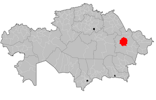
| تفصیل | Map of the rayons of Kazakhstan. Created by Rarelibra 16:49, 3 August 2007 (UTC) for public domain use, using MapInfo Professional v8.5 and various mapping resources. |
| تریخ | (UTC) |
| سروت | |
| لکھاری |
|
| This is a retouched picture, which means that it has been digitally altered from its original version. The original can be viewed here: Kazakhstan rayons.png:
|
Vipera، اس کم دے کاپیرائٹ دا مالک، اس کم نوں اس لائسنس دے مطابق چھاپدا واں:
| میں، اس کم دے کاپیرائٹ دا مالک، اس کم نوں لوکاں واسطے دیندا واں۔ اے سارے جگ واسطے لاگو اے۔ کج ملکاں چ قانونی طور تے اے ممکن نئیں اے؛ اگر انج ای اے ے: میں ہر کسے نوں اس کم نوں کسے وی مقصد واسطے ورتن دا بغیر کسے شرط دے حق دیندا واں، اگر اوہ قانون دے خلاف نا ہوۓ۔ |
پہلا اپلوڈ دا ریکارڈ
This image is a derivative work of the following images:
- File:Kazakhstan_rayons.png licensed with PD-self
- 2007-08-03T16:49:43Z Rarelibra 1601x1025 (56761 Bytes) Map of the rayons of Kazakhstan. Created by ~~~~ for public domain use, using MapInfo Professional v8.5 and various mapping resources.
Uploaded with derivativeFX
پہلا اپلوڈ دا ریکارڈ
| date/time | username | resolution | size | edit summary |
|---|---|---|---|---|
| 2009-08-12T08:56:08Z | User:Vipera | 1601×1025 | 53.85Kb | {{Information |Description=Map of the rayons of Kazakhstan. Created by [[User:Rarelibra|Rarelibra]] 16:49, 3 August 2007 (UTC) for public domain use, using MapInfo Professional v8.5 and various mapping resources. |Source=*[[:File:Kazakhstan_rayons.png|]] |
فائل دی تریخ
فائل نو اس ویلے دی حالت وچ ویکھن واسطے تاریخ/ویلے تے کلک کرو۔
| تریخ تے ویلہ | نکی مورت | پاسے | ورتن والا | تیپّݨی کرو | |
|---|---|---|---|---|---|
| موجودہ | ۱۶:۴۶, ۱۹ جولائی ۲۰۲۳ | | ۱,۵۹۸ × ۱,۰۲۲ (۳۰۶ کلوبائٹ) | Casserium | New regions |
| ۲۱:۰۹, ۵ ستمبر ۲۰۱۱ |  | ۱,۶۰۱ × ۱,۰۲۵ (۹۳ کلوبائٹ) | Sibom | up | |
| ۰۵:۲۴, ۱۳ ستمبر ۲۰۰۹ |  | ۱,۶۰۱ × ۱,۰۲۵ (۵۴ کلوبائٹ) | BetacommandBot | move approved by: User:Superm401 This image was moved from File:Abay District Kazakhstan.png {{Information |Description=Map of the rayons of Kazakhstan. Created by Rarelibra 16:49, 3 August 2007 (UTC) for public domain use, u |
فائل دی ورتوں
تھلے دتے گئے 1 صفحے اس فائل نال جُڑدے نیں
فائل ویاپک ورتوں
ایہہ دوجے وکیاں ایس فائل نوں ورتدے نیں –
- ar.wikipedia.org تے ورتوں
- be.wikipedia.org تے ورتوں
- bg.wikipedia.org تے ورتوں
- el.wikipedia.org تے ورتوں
- en.wikipedia.org تے ورتوں
- fa.wikipedia.org تے ورتوں
- fr.wikipedia.org تے ورتوں
- it.wikipedia.org تے ورتوں
- kk.wikipedia.org تے ورتوں
- mk.wikipedia.org تے ورتوں
- ms.wikipedia.org تے ورتوں
- ru.wikipedia.org تے ورتوں
- vi.wikipedia.org تے ورتوں
- www.wikidata.org تے ورتوں
- zh.wikipedia.org تے ورتوں