
فائل:Sheikh Mujib Road from C&F Tower (02).jpg

اصل فائل (۶,۰۱۶ × ۴,۰۰۰ پکسلز, فائل حجم: ۸.۰۹ میگابائٹ, MIME type: image/jpeg)
خلاصہ
| تفصیل |
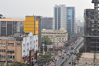
বাংলা: শেখ মুজিব সড়ক, আগ্রাবাদ
English: Sheikh Mujib Road (aerial view, south exposure) from C&F Tower, Agrabad, Chittagong. This road was named after Sheikh Mujibur Rahman, the independence leader of Bangladesh. |
|||||||||||||||||||||||
| تریخ | Taken on ۱۰ فروری ۲۰۱۶, ۱۴:۱۱:۲۸ | |||||||||||||||||||||||
| سروت | آپݨا کم | |||||||||||||||||||||||
| لکھاری |
|
|||||||||||||||||||||||
| اجازت (فائل نوں دوبارہ ورتنا) |
.jpg) License: CC BY-SA 4.0 via Wikimedia Commons This work was published by Moheen Reeyad, and released under the free license CC BY-SA 4.0 which also allows the usage outside of Wikimedia under the following conditions:
Please send me a specimen copy or the URL of the website where the image is used. As a courtesy, however, please let me know about any usage of this photo in any printed medium. Thanks in advance. The Online Attribution Generator offers a good tool to generate an attribution sufficient for your use case. Feel free to contact me via eMail moheenreeyad@wikimedia.org.bd or visit website moheenreeyad.xyz for any questions or in case if you need:
NOTE: Only the terms and conditions mentioned above authorize the free use of this image. Any infringement causes a copyright violation, that may result in a penalty fee of five times the fee suggested by the MFM, inter alia. Templete credit: Martin Kraft, published under the license CC BY-SA 3.0. soucre template)
|
|||||||||||||||||||||||
| دوجے ورژن |
|
|||||||||||||||||||||||
| کس دے ناں (required by the license) | © Moheen Reeyad / Wikimedia Commons / / | |||||||||||||||||||||||
.jpg)
.jpg)
.jpg)
.jpg)
.jpg)
.jpg)

| Camera location | | View this and other nearby images on: OpenStreetMap |
|---|
لائسنس –
- تہانوں کھلھ اے:
- حصہ کرنا – کاپی، ونڈنا تے کم بھیجنا
- فیر رلانا – کم نوں فٹ کرنا
- تھلے دتیاں شرطاں نال:
- کس دے ناں – تسیں لازمی ایس کم دے بناں والے بارے دسو جنج اونے آکھیا اے یا جنج لسنس چ آکھیا گیا ہے۔
- اکو جہا شئیر کرو۔ – اگر تسیں بدلدے یا ایس کم تے بناندے تے بنن والے کم نوں اینج دے لسنس نال ای ونڈو گے۔

|
This image has been assessed under the valued image criteria and is considered the most valued image on Commons within the scope: Sheikh Mujib Road, aerial view, south exposure. You can see its nomination here. |
This image was selected as picture of the day on Bengali Wikipedia.
|
| Annotations | This image is annotated: View the annotations at Commons |
.jpg)
.jpg)
.jpg)
.jpg)
.jpg¶ms=022.324266_N_0091.812256_E_globe:Earth_type:camera_region:BD_&language=pnb)
.jpg)
فائل دی تریخ
فائل نو اس ویلے دی حالت وچ ویکھن واسطے تاریخ/ویلے تے کلک کرو۔
| تریخ تے ویلہ | نکی مورت | پاسے | ورتن والا | تیپّݨی کرو | |
|---|---|---|---|---|---|
| موجودہ | ۱۶:۴۸, ۷ مارچ ۲۰۱۶ | | ۶,۰۱۶ × ۴,۰۰۰ (۸.۰۹ میگابائٹ) | Moheen | User created page with UploadWizard |
فائل دی ورتوں
تھلے دتے گئے 1 صفحے اس فائل نال جُڑدے نیں
فائل ویاپک ورتوں
ایہہ دوجے وکیاں ایس فائل نوں ورتدے نیں –
- bn.wikipedia.org تے ورتوں
- www.wikidata.org تے ورتوں
.jpg)