
فائل:Aerial view of a section of Kandahar in 2013.jpg

ایس وکھالے دا ناپ: ۸۰۰ × ۵۳۱ پکسلز۔ دوجے ریزولوشنز: ۳۲۰ × ۲۱۳ پکسلز | ۶۴۰ × ۴۲۵ پکسلز | ۱,۰۲۴ × ۶۸۰ پکسلز | ۱,۲۸۰ × ۸۵۰ پکسلز | ۲,۵۶۰ × ۱,۷۰۰ پکسلز | ۴,۲۸۸ × ۲,۸۴۸ پکسلز ۔
اصل فائل (۴,۲۸۸ × ۲,۸۴۸ پکسلز, فائل حجم: ۲.۱۵ میگابائٹ, MIME type: image/jpeg)
خلاصہ
| تفصیل |
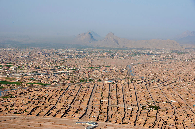
English: Traveling by helicopter enables us to see the beauty of Kandahar province from the air. (USACE Photo by Karla Marshall) |
| تریخ | |
| سروت | https://www.flickr.com/photos/usace-tas/8712299609/ |
| لکھاری | Karla Marshall |
لائسنس –
This image or file is a work of a U.S. Army Corps of Engineers soldier or employee, taken or made as part of that person's official duties. As a work of the U.S. federal government, the image is in the public domain.
|
فائل دی تریخ
فائل نو اس ویلے دی حالت وچ ویکھن واسطے تاریخ/ویلے تے کلک کرو۔
| تریخ تے ویلہ | نکی مورت | پاسے | ورتن والا | تیپّݨی کرو | |
|---|---|---|---|---|---|
| موجودہ | ۱۹:۲۳, ۲۱ مئی ۲۰۱۳ | | ۴,۲۸۸ × ۲,۸۴۸ (۲.۱۵ میگابائٹ) | Officer | {{Information |Description={{en|1=Traveling by helicopter enables us to see the beauty of Kandahar province from the air. (USACE Photo by Karla Marshall)}} |Source=http://www.flickr.com/photos/usace-tas/8713418682/in/photostream/ |Date=2013-05-06 |Auth... |
فائل دی ورتوں
تھلے دتے گئے 2 صفحے اس فائل نال جُڑدے نیں
فائل ویاپک ورتوں
ایہہ دوجے وکیاں ایس فائل نوں ورتدے نیں –
- ar.wikipedia.org تے ورتوں
- arz.wikipedia.org تے ورتوں
- ast.wikipedia.org تے ورتوں
- awa.wikipedia.org تے ورتوں
- azb.wikipedia.org تے ورتوں
- az.wikipedia.org تے ورتوں
- bg.wikipedia.org تے ورتوں
- ca.wikipedia.org تے ورتوں
- ceb.wikipedia.org تے ورتوں
- ckb.wikipedia.org تے ورتوں
- da.wikipedia.org تے ورتوں
- de.wikipedia.org تے ورتوں
- de.wikivoyage.org تے ورتوں
- diq.wikipedia.org تے ورتوں
- el.wikipedia.org تے ورتوں
- en.wikipedia.org تے ورتوں
- en.wikivoyage.org تے ورتوں
- eo.wikipedia.org تے ورتوں
- es.wikipedia.org تے ورتوں
- eu.wikipedia.org تے ورتوں
- fr.wikipedia.org تے ورتوں
- gu.wikipedia.org تے ورتوں
- ha.wikipedia.org تے ورتوں
- he.wikipedia.org تے ورتوں
- he.wikivoyage.org تے ورتوں
- hu.wikipedia.org تے ورتوں
- hy.wikipedia.org تے ورتوں
- incubator.wikimedia.org تے ورتوں
- it.wikipedia.org تے ورتوں
- it.wikivoyage.org تے ورتوں
- ja.wikipedia.org تے ورتوں
- ja.wikivoyage.org تے ورتوں
- ka.wikipedia.org تے ورتوں
- km.wikipedia.org تے ورتوں
- ko.wikipedia.org تے ورتوں
ایس فائل دا ویکھو ہور جگت ورتن .