
فائل:Alaska boroughs and census areas 2013-19.svg

Size of this PNG preview of this SVG file: ۸۰۰ × ۴۵۲ پکسلز. دوجے ریزولوشنز: ۳۲۰ × ۱۸۱ پکسلز | ۶۴۰ × ۳۶۲ پکسلز | ۱,۰۲۴ × ۵۷۹ پکسلز | ۱,۲۸۰ × ۷۲۳ پکسلز | ۲,۵۶۰ × ۱,۴۴۶ پکسلز | ۸۱۶ × ۴۶۱ پکسلز ۔
اصل فائل (ایس وی جی فائل، پکسل:۸۱۶ × ۴۶۱، فائل سائز: ۳۳۴ کلوبائٹ)
خلاصہ
| تفصیل |
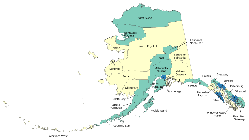
English: Map of boroughs and census areas in Alaska. Green=boroughs, Blue=consolidated city-boroughs, Yellow=census areas (unorganized borough). |
| تریخ | |
| سروت | آپݨا کم |
| لکھاری | Lasunncty |
Made with data from the US Census Bureau.
لائسنس –
میں، اس کم دے کاپیرائٹ دا مالک، اس کم نوں اس لائسنس دے مطابق چھاپدا واں:
ایس فائل نوں کریٹو کامنز Attribution 2.5 پولینڈ لائسنس دتا گیا.
- تہانوں کھلھ اے:
- حصہ کرنا – کاپی، ونڈنا تے کم بھیجنا
- فیر رلانا – کم نوں فٹ کرنا
- تھلے دتیاں شرطاں نال:
- کس دے ناں – تسیں لازمی ایس کم دے بناں والے بارے دسو جنج اونے آکھیا اے یا جنج لسنس چ آکھیا گیا ہے۔
- اکو جہا شئیر کرو۔ – اگر تسیں بدلدے یا ایس کم تے بناندے تے بنن والے کم نوں اینج دے لسنس نال ای ونڈو گے۔
فائل دی تریخ
فائل نو اس ویلے دی حالت وچ ویکھن واسطے تاریخ/ویلے تے کلک کرو۔
| تریخ تے ویلہ | نکی مورت | پاسے | ورتن والا | تیپّݨی کرو | |
|---|---|---|---|---|---|
| موجودہ | ۱۵:۳۰, ۲ جون ۲۰۲۰ | | ۸۱۶ × ۴۶۱ (۳۳۴ کلوبائٹ) | Lasunncty | Reverted to version as of 04:02, 14 December 2016 (UTC) - Confused Petersburg Census area with Petersburg Borough |
| ۱۷:۳۷, ۱ جون ۲۰۲۰ |  | ۸۱۶ × ۴۶۱ (۴۷۷ کلوبائٹ) | BorderRegions | Fixed Petersburg Borough borders, and Hoonah–Angoon Census Area border - both of which did not have included all their appropriate territory. Previous two versions didn't actually register changes. | |
| ۱۶:۴۹, ۱ جون ۲۰۲۰ |  | ۱,۱۶۸ × ۶۴۸ (۲۴۶ کلوبائٹ) | BorderRegions | Fixed Petersburg Borough borders, and Hoonah–Angoon Census Area border - both of which did not have included all their appropriate territory. | |
| ۱۶:۴۰, ۱ جون ۲۰۲۰ |  | ۱,۱۶۸ × ۶۴۸ (۱۲۴ کلوبائٹ) | BorderRegions | Fixed Petersburg Borough borders, and Hoonah–Angoon Census Area border - both of which did not have included all their appropriate territory. | |
| ۰۹:۰۲, ۱۴ دسمبر ۲۰۱۶ |  | ۸۱۶ × ۴۶۱ (۳۳۴ کلوبائٹ) | Kingofthedead | Kusilvak | |
| ۱۴:۰۰, ۹ جون ۲۰۱۵ |  | ۸۱۶ × ۴۶۱ (۳۳۴ کلوبائٹ) | Lasunncty | Corrected Haines and Yakutat. Not actually unified government despite their names. | |
| ۱۴:۱۸, ۲۴ دسمبر ۲۰۱۴ |  | ۸۱۶ × ۴۶۱ (۳۳۴ کلوبائٹ) | Lasunncty | New map as of Jan 2013 |
فائل دی ورتوں
اس فائل نال جڑیا کوئی صفحہ نئیں۔
فائل ویاپک ورتوں
ایہہ دوجے وکیاں ایس فائل نوں ورتدے نیں –
- de.wikipedia.org تے ورتوں
- zh.wikipedia.org تے ورتوں