
فائل:Ancient Regions Central Greece.png

ایس وکھالے دا ناپ: ۶۰۰ × ۶۰۰ پکسلز۔ دوجے ریزولوشنز: ۲۴۰ × ۲۴۰ پکسلز | ۴۸۰ × ۴۸۰ پکسلز ۔
اصل فائل (۸۰۰ × ۸۰۰ پکسلز, فائل حجم: ۳۹۳ کلوبائٹ, MIME type: image/png)
| تفصیل |
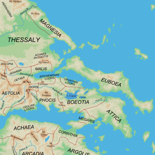
English: Map of the central regions of Ancient Greece |
| تریخ | (UTC) |
| سروت |
|
| لکھاری | User:MinisterForBadTimes |
| دوجے ورژن |
Derivative works of this file: |
| This is a retouched picture, which means that it has been digitally altered from its original version. The original can be viewed here: Ancient Greek southern regions.png:
|
میں، اس کم دے کاپیرائٹ دا مالک، اس کم نوں اس لائسنس دے مطابق چھاپدا واں:
ایس فائل نوں کریٹو کامنز Attribution 2.5 جنرک لائسنس دتا گیا.
- تہانوں کھلھ اے:
- حصہ کرنا – کاپی، ونڈنا تے کم بھیجنا
- فیر رلانا – کم نوں فٹ کرنا
- تھلے دتیاں شرطاں نال:
- کس دے ناں – تسیں لازمی ایس کم دے بناں والے بارے دسو جنج اونے آکھیا اے یا جنج لسنس چ آکھیا گیا ہے۔
- اکو جہا شئیر کرو۔ – اگر تسیں بدلدے یا ایس کم تے بناندے تے بنن والے کم نوں اینج دے لسنس نال ای ونڈو گے۔
| ایس فائل نوں کریٹو کامنز Attribution 2.5 پولینڈ لائسنس دتا گیا. | ||
| ||
| اس لائسنس دا ٹیگ GFDL دے مطابق اس فائل چ پایا گیا اے licensing update۔ |

|
کاپی کرن، ونڈن تے بدلن دی ایس ڈوکومنٹ لئی اجازت دتی جاندی اے ایہناں GNU Free Documentation License, Version 1.2 شرطاں نال یا مگروں کسے وی چھپے ورین Free Software Foundation توں بنا کسے انویرینٹ سیکشن دے، ناں فرنٹ کور لکھت تے ناں بیک کور لکھت دے۔ لسنس دی اک کاپی سیکشن وچ ہیگی اے جہدا ناں اے GNU Free Documentation License۔ |
تسیں اپنی مرضی دا لائسنس چݨ سکدے اوہ۔
پہلا اپلوڈ دا ریکارڈ
This image is a derivative work of the following images:
- File:Ancient_Greek_southern_regions.png licensed with Cc-by-sa-2.5, Cc-by-sa-3.0-migrated, GFDL
- 2010-01-12T08:44:56Z MinisterForBadTimes 800x800 (385822 Bytes) {{Information |Description={{en|Map of the regions of Ancient Greece}} |Source=*[[:File:Map_greek_sanctuaries-en.svg|]]. Geographical information based on public domain map of Greece, from the Perry-Castañeda Library Map Col
Uploaded with derivativeFX
فائل دی تریخ
فائل نو اس ویلے دی حالت وچ ویکھن واسطے تاریخ/ویلے تے کلک کرو۔
| تریخ تے ویلہ | نکی مورت | پاسے | ورتن والا | تیپّݨی کرو | |
|---|---|---|---|---|---|
| موجودہ | ۰۱:۴۱, ۴ مارچ ۲۰۱۰ | | ۸۰۰ × ۸۰۰ (۳۹۳ کلوبائٹ) | MinisterForBadTimes | Two spellings corrected |
| ۰۲:۴۴, ۲ مارچ ۲۰۱۰ |  | ۸۰۰ × ۸۰۰ (۳۹۳ کلوبائٹ) | MinisterForBadTimes | {{Information |Description={{en|Map of the central regions of Ancient Greece}} |Source=*blank(ish) map from Ancient_Greek_southern_regions.png, ultimately derived from [[:File:Map_greek_sanctuaries-en.svg|Map_g |
فائل دی ورتوں
تھلے دتے گئے 1 صفحے اس فائل نال جُڑدے نیں
فائل ویاپک ورتوں
ایہہ دوجے وکیاں ایس فائل نوں ورتدے نیں –
- azb.wikipedia.org تے ورتوں
- bg.wikipedia.org تے ورتوں
- cs.wikipedia.org تے ورتوں
- de.wikipedia.org تے ورتوں
- el.wikipedia.org تے ورتوں
- en.wikipedia.org تے ورتوں
- et.wikipedia.org تے ورتوں
- fi.wikipedia.org تے ورتوں
- fr.wikipedia.org تے ورتوں
- hu.wikipedia.org تے ورتوں
- id.wikipedia.org تے ورتوں
- it.wikipedia.org تے ورتوں
- ja.wikipedia.org تے ورتوں
- ja.wikibooks.org تے ورتوں
- la.wikipedia.org تے ورتوں
- nn.wikipedia.org تے ورتوں
- pl.wiktionary.org تے ورتوں
- ru.wikipedia.org تے ورتوں
- sl.wikipedia.org تے ورتوں
- sq.wikipedia.org تے ورتوں
- tr.wikipedia.org تے ورتوں
- uk.wikipedia.org تے ورتوں
ایس فائل دا ویکھو ہور جگت ورتن .