
فائل:Atbara river map.jpg

ایس وکھالے دا ناپ: ۸۰۰ × ۴۶۶ پکسلز۔ دوجے ریزولوشنز: ۳۲۰ × ۱۸۶ پکسلز | ۶۴۰ × ۳۷۲ پکسلز | ۱,۱۴۱ × ۶۶۴ پکسلز ۔
اصل فائل (۱,۱۴۱ × ۶۶۴ پکسلز, فائل حجم: ۱۹۸ کلوبائٹ, MIME type: image/jpeg)
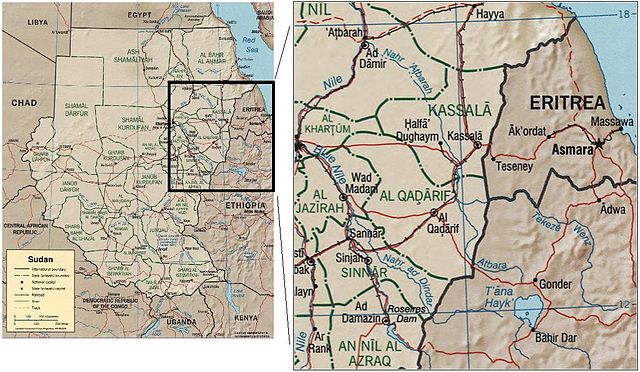
The Atbara river, in Sudan and Eritrea. Source: image:Sudan political map 2000.jpg
CIA map of Sudan from 2000
http://hdl.loc.gov/loc.gmd/g8310.ct001564
| This image is a work of a Central Intelligence Agency employee, taken or made as part of that person's official duties. As a Work of the United States Government, this image or media is in the public domain in the United States.
|

|
فائل دی تریخ
فائل نو اس ویلے دی حالت وچ ویکھن واسطے تاریخ/ویلے تے کلک کرو۔
| تریخ تے ویلہ | نکی مورت | پاسے | ورتن والا | تیپّݨی کرو | |
|---|---|---|---|---|---|
| موجودہ | ۱۷:۲۶, ۲۲ ستمبر ۲۰۰۶ | | ۱,۱۴۱ × ۶۶۴ (۱۹۸ کلوبائٹ) | Laur2ro | The Atbara river, in Sudan and Eritrea. Source: image:Sudan political map 2000.jpg CIA map of Sudan from 2000 http://hdl.loc.gov/loc.gmd/g8310.ct001564 {{PD-USGov-CIA}} Category:Maps of Sudan |
فائل دی ورتوں
اس فائل نال جڑیا کوئی صفحہ نئیں۔
فائل ویاپک ورتوں
ایہہ دوجے وکیاں ایس فائل نوں ورتدے نیں –
- ar.wikipedia.org تے ورتوں
- az.wikipedia.org تے ورتوں
- be.wikipedia.org تے ورتوں
- ca.wikipedia.org تے ورتوں
- ceb.wikipedia.org تے ورتوں
- cs.wikipedia.org تے ورتوں
- da.wikipedia.org تے ورتوں
- de.wikipedia.org تے ورتوں
- es.wikipedia.org تے ورتوں
- et.wikipedia.org تے ورتوں
- eu.wikipedia.org تے ورتوں
- fi.wikipedia.org تے ورتوں
- fr.wikipedia.org تے ورتوں
- he.wikipedia.org تے ورتوں
- hu.wikipedia.org تے ورتوں
- it.wikipedia.org تے ورتوں
- ml.wikipedia.org تے ورتوں
- nl.wikipedia.org تے ورتوں
- pl.wikipedia.org تے ورتوں
- pt.wikipedia.org تے ورتوں
- ro.wikipedia.org تے ورتوں
- ru.wikipedia.org تے ورتوں
- sh.wikipedia.org تے ورتوں
- uk.wikipedia.org تے ورتوں
- uz.wikipedia.org تے ورتوں
- www.wikidata.org تے ورتوں
- xmf.wikipedia.org تے ورتوں
- zh.wikipedia.org تے ورتوں