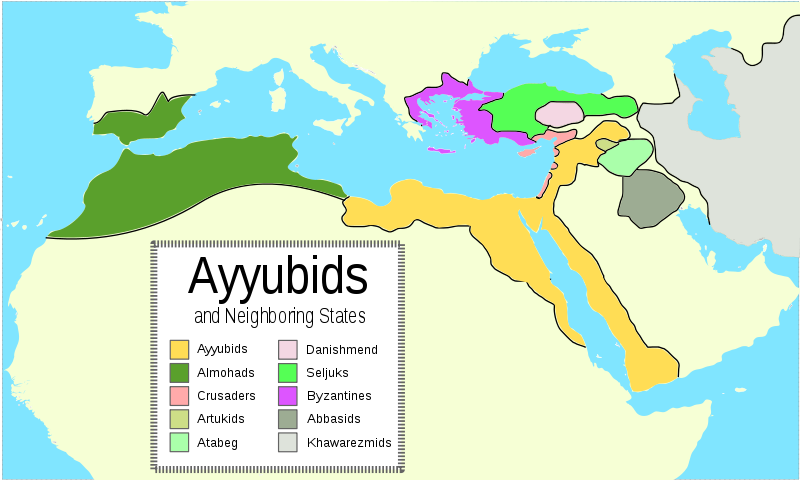
فائل:Ayyubid Dynasty.svg
Appearance

Size of this PNG preview of this SVG file: ۸۰۰ × ۴۸۰ پکسلز. دوجے ریزولوشنز: ۳۲۰ × ۱۹۲ پکسلز | ۱,۰۲۴ × ۶۱۴ پکسلز | ۱,۲۸۰ × ۷۶۸ پکسلز | ۲,۵۶۰ × ۱,۵۳۶ پکسلز | ۲,۰۰۷ × ۱,۲۰۴ پکسلز ۔
اصل فائل (ایس وی جی فائل، پکسل:۲,۰۰۷ × ۱,۲۰۴، فائل سائز: ۲۲۷ کلوبائٹ)
فائل دی تریخ
فائل نو اس ویلے دی حالت وچ ویکھن واسطے تاریخ/ویلے تے کلک کرو۔
| تریخ تے ویلہ | نکی مورت | پاسے | ورتن والا | تیپّݨی کرو | |
|---|---|---|---|---|---|
| موجودہ | ۰۲:۴۶, ۴ اکتوبر ۲۰۲۴ |  | ۲,۰۰۷ × ۱,۲۰۴ (۲۲۷ کلوبائٹ) | Zemen | File uploaded using svgtranslate tool (https://svgtranslate.toolforge.org/). Added translation for ckb. |
| ۰۳:۳۸, ۱۵ جولائی ۲۰۰۹ |  | ۲,۰۰۷ × ۱,۲۰۴ (۲۲۱ کلوبائٹ) | Fjmustak | Used Arial font for the legend. | |
| ۱۱:۴۵, ۲۲ مئی ۲۰۰۹ |  | ۲,۰۰۷ × ۱,۲۰۴ (۲۱۵ کلوبائٹ) | Fjmustak | Removed black box | |
| ۱۱:۳۴, ۲۲ مئی ۲۰۰۹ |  | ۲,۰۰۷ × ۱,۲۰۴ (۲۱۴ کلوبائٹ) | Fjmustak | Removed distinction between Fatimid held areas and rest of Ayyubid Dynasty, added Almohads, legend + minor changes. | |
| ۱۱:۰۲, ۱۴ مئی ۲۰۰۹ |  | ۲,۰۰۷ × ۱,۲۰۴ (۲۰۲ کلوبائٹ) | Fjmustak | Fixed size | |
| ۱۰:۵۳, ۱۴ مئی ۲۰۰۹ |  | ۹۴۰ × ۴۷۷ (۲۰۲ کلوبائٹ) | Fjmustak | {{Information |Description={{en|1=Map of the Ayyubid empire and the surrounding empires in the 12th century. Yellow area is the area under Fatimid rule until 1171, and the "peach" colored areas are the regions conquered by Saladin.}} |Source=Own work by |
فائل دی ورتوں
تھلے دتے گئے 1 صفحے اس فائل نال جُڑدے نیں
فائل ویاپک ورتوں
ایہہ دوجے وکیاں ایس فائل نوں ورتدے نیں –
- ckb.wikipedia.org تے ورتوں
- de.wikipedia.org تے ورتوں
- en.wikipedia.org تے ورتوں
- es.wikipedia.org تے ورتوں
- et.wikipedia.org تے ورتوں
- fr.wikipedia.org تے ورتوں
- he.wikipedia.org تے ورتوں
- it.wikipedia.org تے ورتوں
- ja.wikipedia.org تے ورتوں
- mg.wikipedia.org تے ورتوں
- sl.wikipedia.org تے ورتوں
- sv.wikipedia.org تے ورتوں
- uk.wikipedia.org تے ورتوں
- ur.wikipedia.org تے ورتوں
- zh.wikipedia.org تے ورتوں

