
فائل:BeringSt-close-VE.jpg

ایس وکھالے دا ناپ: ۸۰۰ × ۵۰۱ پکسلز۔ دوجے ریزولوشنز: ۳۲۰ × ۲۰۰ پکسلز | ۶۴۰ × ۴۰۱ پکسلز | ۱,۰۴۳ × ۶۵۳ پکسلز ۔
اصل فائل (۱,۰۴۳ × ۶۵۳ پکسلز, فائل حجم: ۱۱۲ کلوبائٹ, MIME type: image/jpeg)
| تفصیل |
|
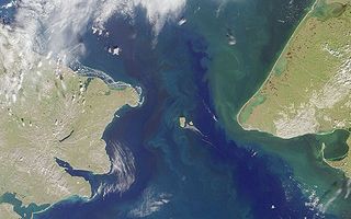
| سروت | original from http://www.visibleearth.nasa.gov/cgi-bin/viewrecord?7049 |
| لکھاری | NASA |
| اجازت (فائل نوں دوبارہ ورتنا) |
PD-USGov-NASA |
| This file is in the public domain in the United States because it was solely created by NASA. NASA copyright policy states that "NASA material is not protected by copyright unless noted". (See Template:PD-USGov, NASA copyright policy page or JPL Image Use Policy.) | ||
 |
Warnings:
|
| Annotations | This image is annotated: View the annotations at Commons |
فائل دی تریخ
فائل نو اس ویلے دی حالت وچ ویکھن واسطے تاریخ/ویلے تے کلک کرو۔
| تریخ تے ویلہ | نکی مورت | پاسے | ورتن والا | تیپّݨی کرو | |
|---|---|---|---|---|---|
| موجودہ | ۲۰:۱۶, ۶ اپریل ۲۰۰۵ | | ۱,۰۴۳ × ۶۵۳ (۱۱۲ کلوبائٹ) | Laurens~commonswiki | Bering strait NASA image, MISR sattelite |
فائل دی ورتوں
تھلے دتے گئے 4 صفحے اس فائل نال جُڑدے نیں
فائل ویاپک ورتوں
ایہہ دوجے وکیاں ایس فائل نوں ورتدے نیں –
- af.wikipedia.org تے ورتوں
- als.wikipedia.org تے ورتوں
- ar.wikipedia.org تے ورتوں
- ary.wikipedia.org تے ورتوں
- ast.wikipedia.org تے ورتوں
- az.wikipedia.org تے ورتوں
- ba.wikipedia.org تے ورتوں
- be-tarask.wikipedia.org تے ورتوں
- be.wikipedia.org تے ورتوں
- bg.wikipedia.org تے ورتوں
- bn.wikipedia.org تے ورتوں
- bs.wikipedia.org تے ورتوں
- ckb.wikipedia.org تے ورتوں
- cs.wikipedia.org تے ورتوں
- cv.wikipedia.org تے ورتوں
- da.wikipedia.org تے ورتوں
- de.wikipedia.org تے ورتوں
- el.wikipedia.org تے ورتوں
- en.wikipedia.org تے ورتوں
- en.wiktionary.org تے ورتوں
- eo.wikipedia.org تے ورتوں
- es.wikipedia.org تے ورتوں
- et.wikipedia.org تے ورتوں
ایس فائل دا ویکھو ہور جگت ورتن .