
فائل:BritishEmpire1919.png
ایس وکھالے دا ناپ: ۸۰۰ × ۴۰۹ پکسلز۔ دوجے ریزولوشنز: ۳۲۰ × ۱۶۳ پکسلز | ۶۴۰ × ۳۲۷ پکسلز | ۱,۴۲۵ × ۷۲۸ پکسلز ۔
اصل فائل (۱,۴۲۵ × ۷۲۸ پکسلز, فائل حجم: ۵۲ کلوبائٹ, MIME type: image/png)

|
This historical map image could be re-created using vector graphics as an SVG file. This has several advantages; see Commons:Media for cleanup for more information. If an SVG form of this image is available, please upload it and afterwards replace this template with
{{vector version available|new image name}}.
It is recommended to name the SVG file “BritishEmpire1919.svg”—then the template Vector version available (or Vva) does not need the new image name parameter. |
خلاصہ
| تفصیل |
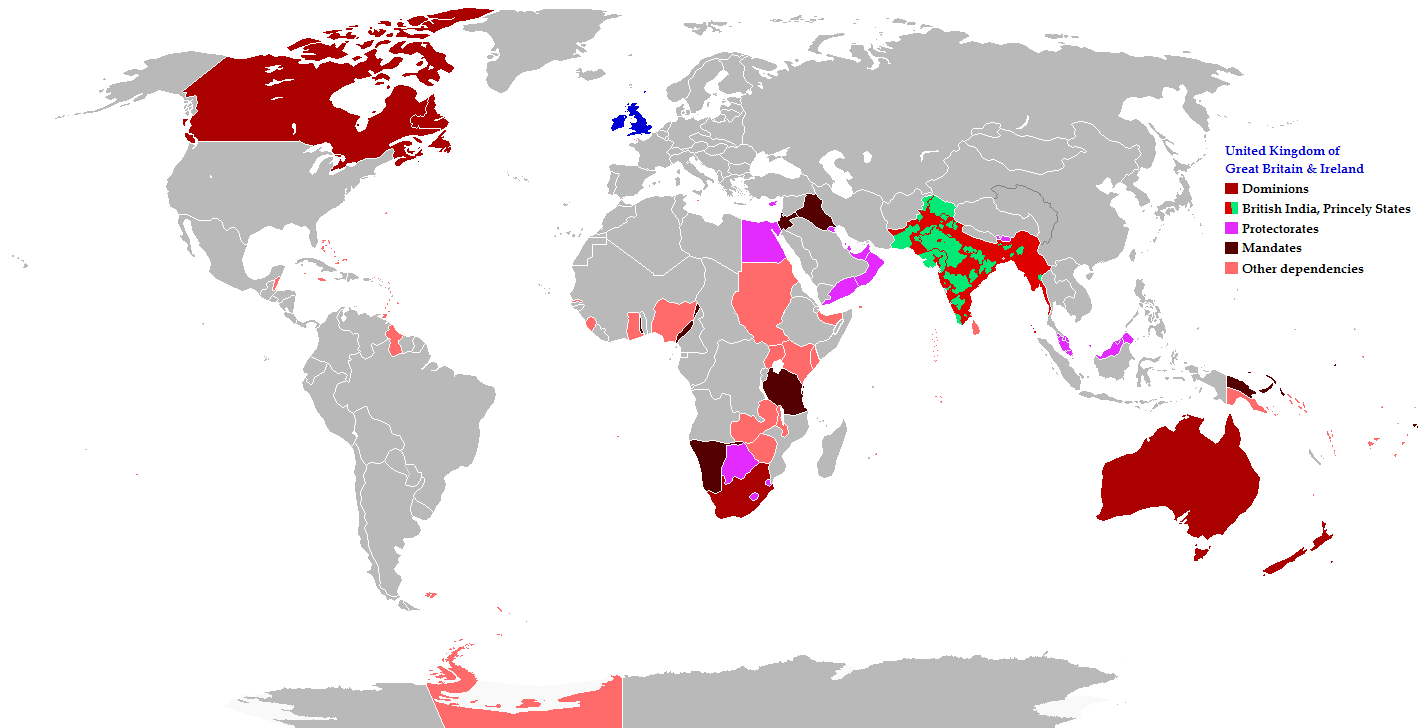
English: Map of the British Empire in 1919 showing all the territories, including the dominions, colonies, protectorates and mandates, ruled or administered by the United Kingdom and its successor states during that year.
Français : Carte de l'Empire britannique en 1919 illustrant tous les territoires, tels que les dominions, colonies, protectorats et mandats, gouvernés ou administrés par le Royaume-Uni ou ses États successeurs cette année-là.
Español: Un mapa de todas las afirmaciones oficiales territorial del Imperio Británico que se celebró en 1919 que identifica qué tipo de celebración estaba presente en todas las posesiones durante ese año.
Deutsch: Eine Karte aller offiziellen territorialen Ansprüche des Britischen Empire, die es im Jahre 1919 hatte, nach Art der Besitzungen in diesem Jahr.
فارسی: نقشه بیمورد از همه ادعاهای ارضی رسمی امپراطوری بریتانیا که در سال 1919 که برای شناسایی نوع برگزاری در حال حاضر تمام اموال در آن سال برگزار شد.
Português: Mapa de todos os territórios reclamados pelo Império Britânico, em 1919, que identifica o tipo de presença britânica no local naquele ano. |
| تریخ | |
| سروت |
The following: |
| لکھاری | Maps & Lucy |
| اجازت (فائل نوں دوبارہ ورتنا) |
Released into the public domain (by the author). |
| دوجے ورژن | العربيَّة |
Legend
Deutsch (de):
لائسنس –
ایس فائل نوں کریٹو کامنز Attribution 2.5 جنرک لائسنس دتا گیا.
- تہانوں کھلھ اے:
- حصہ کرنا – کاپی، ونڈنا تے کم بھیجنا
- فیر رلانا – کم نوں فٹ کرنا
- تھلے دتیاں شرطاں نال:
- کس دے ناں – تسیں لازمی ایس کم دے بناں والے بارے دسو جنج اونے آکھیا اے یا جنج لسنس چ آکھیا گیا ہے۔
- اکو جہا شئیر کرو۔ – اگر تسیں بدلدے یا ایس کم تے بناندے تے بنن والے کم نوں اینج دے لسنس نال ای ونڈو گے۔
فائل دی تریخ
فائل نو اس ویلے دی حالت وچ ویکھن واسطے تاریخ/ویلے تے کلک کرو۔
| تریخ تے ویلہ | نکی مورت | پاسے | ورتن والا | تیپّݨی کرو | |
|---|---|---|---|---|---|
| موجودہ | ۱۳:۲۶, ۳۱ اکتوبر ۲۰۲۱ | | ۱,۴۲۵ × ۷۲۸ (۵۲ کلوبائٹ) | Randomastwritter | jubaland |
| ۰۱:۴۳, ۱۸ نومبر ۲۰۱۴ |  | ۱,۴۲۵ × ۷۲۸ (۶۱ کلوبائٹ) | GrenaderGD44 | Убраны артефакты с карты в районе Антарктиды | |
| ۰۶:۴۰, ۱۷ نومبر ۲۰۱۴ |  | ۱,۴۲۵ × ۷۲۸ (۶۵ کلوبائٹ) | GrenaderGD44 | Бутан - протекторат с 1910 года | |
| ۲۳:۳۶, ۹ مارچ ۲۰۱۴ |  | ۱,۴۲۵ × ۶۲۵ (۳۹ کلوبائٹ) | Htonl | Bechuanaland, Basutoland and Swaziland were protectorates | |
| ۰۱:۰۲, ۱۹ جون ۲۰۱۱ |  | ۱,۴۲۵ × ۶۲۵ (۵۵ کلوبائٹ) | Maps & Lucy | The British Empire, Mongolia and the Soviet Union all recognized Tibet as an independent state and the British Empire via British India were heavily involved in Tibet's independence. | |
| ۰۰:۰۵, ۸ مئی ۲۰۱۱ |  | ۱,۴۲۵ × ۶۲۵ (۵۸ کلوبائٹ) | Quigley | Correct China's borders closer to what was internationally recognized at the time | |
| ۰۴:۵۵, ۱۶ دسمبر ۲۰۱۰ |  | ۱,۴۲۵ × ۶۲۵ (۵۵ کلوبائٹ) | Maps & Lucy | Added protectorates and Princely States | |
| ۰۳:۴۷, ۱۱ دسمبر ۲۰۱۰ |  | ۱,۴۲۵ × ۶۲۵ (۵۳ کلوبائٹ) | Maps & Lucy | Papua was a colony not a dominion, Gold Coast did not include British Togoland and British Togoland was a mandate. | |
| ۲۳:۲۰, ۷ نومبر ۲۰۱۰ |  | ۱,۴۲۵ × ۶۲۵ (۵۹ کلوبائٹ) | Spesh531 | fix mistake in botswana | |
| ۲۳:۱۹, ۷ نومبر ۲۰۱۰ |  | ۱,۴۲۵ × ۶۲۵ (۵۶ کلوبائٹ) | Spesh531 | really a way to revert. use this version |
فائل دی ورتوں
تھلے دتے گئے 1 صفحے اس فائل نال جُڑدے نیں
فائل ویاپک ورتوں
ایہہ دوجے وکیاں ایس فائل نوں ورتدے نیں –
- af.wikipedia.org تے ورتوں
- ar.wikipedia.org تے ورتوں
- azb.wikipedia.org تے ورتوں
- az.wikipedia.org تے ورتوں
- ba.wikipedia.org تے ورتوں
- be-tarask.wikipedia.org تے ورتوں
- be.wikipedia.org تے ورتوں
- bg.wikipedia.org تے ورتوں
- bs.wikipedia.org تے ورتوں
- bxr.wikipedia.org تے ورتوں
- cdo.wikipedia.org تے ورتوں
- de.wikipedia.org تے ورتوں
- el.wikipedia.org تے ورتوں
- en.wikipedia.org تے ورتوں
- eo.wikipedia.org تے ورتوں
- fiu-vro.wikipedia.org تے ورتوں
- fi.wikipedia.org تے ورتوں
- fr.wikipedia.org تے ورتوں
- he.wikipedia.org تے ورتوں
- hif.wikipedia.org تے ورتوں
- hr.wikipedia.org تے ورتوں
- hy.wikipedia.org تے ورتوں
- ia.wikipedia.org تے ورتوں
- id.wikipedia.org تے ورتوں
- is.wikipedia.org تے ورتوں
- ja.wikipedia.org تے ورتوں
- kk.wikipedia.org تے ورتوں
- krc.wikipedia.org تے ورتوں
- lez.wikipedia.org تے ورتوں
- lo.wikipedia.org تے ورتوں
- lv.wikipedia.org تے ورتوں
- ms.wikipedia.org تے ورتوں
- mwl.wikipedia.org تے ورتوں
- my.wikipedia.org تے ورتوں
- nl.wikipedia.org تے ورتوں
- nn.wikipedia.org تے ورتوں
- qu.wikipedia.org تے ورتوں
- ru.wikipedia.org تے ورتوں
ایس فائل دا ویکھو ہور جگت ورتن .