
فائل:CH-NB Photoglob-Wehrli EAD-WEHR-32043-B.tiff

اصل فائل (۴,۶۴۲ × ۳,۴۷۱ پکسلز, فائل حجم: ۱۵.۴ میگابائٹ, MIME type: image/tiff)
خلاصہ
| Kairo, Landschaft
( |
|||||||||||||||||||||||||||
|---|---|---|---|---|---|---|---|---|---|---|---|---|---|---|---|---|---|---|---|---|---|---|---|---|---|---|---|
| Photographer |
|
||||||||||||||||||||||||||
| سرخی |
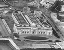
Kairo, Landschaft |
||||||||||||||||||||||||||
| تفصیل |
Aegypten, Kairo und Nil aus ca. 500 m Höhe, Ballonaufnahme |
||||||||||||||||||||||||||
| Depicted place | Kairo | ||||||||||||||||||||||||||
| تریخ | ۱۹۰۴ | ||||||||||||||||||||||||||
| میڈیم | photograph | ||||||||||||||||||||||||||
| ڈائمنشن | height: ۱۸.۰ cm؛ width: ۲۴.۰ cm | ||||||||||||||||||||||||||
| Collection |
|
||||||||||||||||||||||||||
| ہن والی تھاں |
Prints and Drawings Department, Federal Archives of historic monuments |
||||||||||||||||||||||||||
| ملن نمبر |
EAD-WEHR-32043-B |
||||||||||||||||||||||||||
| نوٹس | Published by Wehrli AG (1904-1924) [GND-ID 16137188-7] | ||||||||||||||||||||||||||
| سروت | https://www.helveticarchives.ch/detail.aspx?id=162814 | ||||||||||||||||||||||||||
| اجازت (فائل نوں دوبارہ ورتنا) |
|
||||||||||||||||||||||||||
| دوجے ورژن | |||||||||||||||||||||||||||
.jpg)


| Camera location | | View this and other nearby images on: OpenStreetMap |
|---|
لائسنس –
|
The author died in 1931, so this work is in the public domain in its country of origin and other countries and areas where the copyright term is the author's life plus 80 years or fewer. This work is in the public domain in the United States because it was published (or registered with the U.S. Copyright Office) before January 1, 1929. | |
| ایہ فائل دے بارے چ دس اے جے اے کاپی حف دیاں روکاں توں کھلی اے تے نالدے رلدے حقاں توں وی۔ | |
فائل دی تریخ
فائل نو اس ویلے دی حالت وچ ویکھن واسطے تاریخ/ویلے تے کلک کرو۔
| تریخ تے ویلہ | نکی مورت | پاسے | ورتن والا | تیپّݨی کرو | |
|---|---|---|---|---|---|
| موجودہ | ۱۴:۱۱, ۲۲ مئی ۲۰۱۴ |  | ۴,۶۴۲ × ۳,۴۷۱ (۱۵.۴ میگابائٹ) | Swiss National Library | {{Information |Description ={{en|1=tmp}} |Source =tmp |Author =tmp |Date = |Permission = |other_versions = }} |
فائل دی ورتوں
تھلے دتے گئے 1 صفحے اس فائل نال جُڑدے نیں
فائل ویاپک ورتوں
ایہہ دوجے وکیاں ایس فائل نوں ورتدے نیں –
- ar.wikipedia.org تے ورتوں
- bn.wikipedia.org تے ورتوں
- de.wikipedia.org تے ورتوں
- en.wikipedia.org تے ورتوں
- eo.wikipedia.org تے ورتوں
- fr.wikipedia.org تے ورتوں
- hy.wikipedia.org تے ورتوں
- ig.wikipedia.org تے ورتوں
- it.wikipedia.org تے ورتوں
- la.wikipedia.org تے ورتوں
- si.wikipedia.org تے ورتوں
- sl.wikipedia.org تے ورتوں
- tl.wikipedia.org تے ورتوں
- ur.wikipedia.org تے ورتوں
- vi.wikipedia.org تے ورتوں
- zh.wikipedia.org تے ورتوں