فائل:Cathédrale Saint-Étienne de Toulouse - Salomon tenant le plan de Jérusalem par Despax PM31000747.jpg

Page contents not supported in other languages.
آزاد انسائیکلوپیڈیا، وکیپیڈیا توں

اصل فائل(۲,۹۶۰ × ۴,۰۴۸ پکسلز, فائل حجم: ۵.۷۹ میگابائٹ, MIME type: image/jpeg)

ایہ فائل Wikimedia Commons توں اے تے دوجیاں ویونتاں تے وی ورتی جاسکدی اے۔ گل بات اس دے فائل گل بات صفحہ تے تھلے دتی گئی۔

خلاصہ

Cathédrale Saint-Étienne from Toulouse, Solomon holding the map of Jerusalem by Jean-Baptiste Despax

VI seal

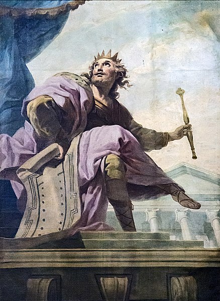
This image has been assessed under the valued image criteria and is considered the most valued image on Commons within the scope: Cathédrale Saint-Étienne from Toulouse, Solomon holding the map of Jerusalem by Jean-Baptiste Despax. You can see its nomination here.

Object

آرٹسٹ
Jean-Baptiste Despax  (1710–1773)  wikidata:Q3164021
 
Jean-Baptiste Despax
ہور ناں
Jean Baptiste Despax
گل بات French مصور
جمن/مرن دیہاڑہ ۱۷ جون ۱۷۱۰ Edit this at Wikidata ۳ نومبر ۱۷۷۳ Edit this at Wikidata
جمن/مرن دی تھاں تولوز تولوز
کم ویلہ ۱۷۳۰ Edit this at Wikidata–۱۷۷۳ Edit this at Wikidata
کم تھاں
پیرس (۱۷۴۲–۱۷۴۶); تولوز (۱۷۴۶–۱۷۷۳) Edit this at Wikidata
Authority file
artist QS:P170,Q3164021
Object type painting
object_type QS:P31,Q3305213
تفصیل
English: Solomon holding the map of Jerusalem
Français : Salomon tenant le plan de Jérusalem
تریخ 18 century
date QS:P571,+1750-00-00T00:00:00Z/7
میڈیم oil on canvas
medium QS:P186,Q296955;P186,Q12321255,P518,Q861259
institution QS:P195,Q2737833

فوٹو

تریخ Taken on ۶ جولائی ۲۰۱۶
سروت آپݨا کم
لکھاری Didier Descouens
اجازت
(فائل نوں دوبارہ ورتنا)
This file is copyrighted and has been released under a license which is incompatible with Facebook's licensing terms. It is not permitted to upload this file at Facebook.
میں، اس کم دے کاپیرائٹ دا مالک، اس کم نوں اس لائسنس دے مطابق چھاپدا واں:
w:en:Creative Commons
کس دے ناں اکو جہا شئیر کرو۔
This file is licensed under the Creative Commons Attribution-Share Alike 4.0 International license.
تہانوں کھلھ اے:
  • حصہ کرنا – کاپی، ونڈنا تے کم بھیجنا
  • فیر رلانا – کم نوں فٹ کرنا
تھلے دتیاں شرطاں نال:
  • کس دے ناں – تسیں لازمی ایس کم دے بناں والے بارے دسو جنج اونے آکھیا اے یا جنج لسنس چ آکھیا گیا ہے۔
  • اکو جہا شئیر کرو۔ – اگر تسیں بدلدے یا ایس کم تے بناندے تے بنن والے کم نوں اینج دے لسنس نال ای ونڈو گے۔

لائسنس –

This is a faithful photographic reproduction of a two-dimensional, public domain work of art. The work of art itself is in the public domain for the following reason:
Public domain

This work is in the public domain in its country of origin and other countries and areas where the copyright term is the author's life plus 100 years or fewer.


You must also include a United States public domain tag to indicate why this work is in the public domain in the United States.
The official position taken by the Wikimedia Foundation is that "faithful reproductions of two-dimensional public domain works of art are public domain".
This photographic reproduction is therefore also considered to be in the public domain in the United States. In other jurisdictions, re-use of this content may be restricted; see Reuse of PD-Art photographs for details.
This building is classé au titre des monuments historiques de la France. It is indexed in the base Mérimée, a database of architectural heritage maintained by the French Ministry of Culture, under the reference PA00094498 .

brezhoneg  català  Deutsch  English  español  Esperanto  euskara  français  italiano  magyar  Nederlands  português do Brasil  português  română  sicilianu  slovenščina  suomi  svenska  Ελληνικά  беларуская (тарашкевіца)  македонски  русский  українська  বাংলা  +/−
Logo monuments historiques
This object is classé Monument Historique in the base Palissy, database of the French furniture patrimony of the French ministry of culture, under the reference PM31000747.

беларуская (тарашкевіца)  brezhoneg  català  Deutsch  English  español  suomi  français  magyar  italiano  日本語  македонски  Plattdüütsch  português  русский  українська  +/−
Object location۴۳° ۳۵′ ۵۹.۶۴″ N, ۱° ۲۷′ ۰۱.۴۴″ E Kartographer map based on OpenStreetMap.View this and other nearby images on: OpenStreetMapinfo

Captions

Add a one-line explanation of what this file represents

Items portrayed in this file

چترن

copyrighted English

captured with English

Nikon D800E English

۶ جولائی 2016

43°35'59.640"N, 1°27'1.440"E

exposure time English

۰.۰۲ سکنٹ

f-number English

۵

focal length English

۸۲ ملی میٹر

ISO speed English

۶,۴۰۰

MIME type English

image/jpeg

checksum English

710e7162f1fcc7a67faf1a38fd99de95430de126

determination method English: ؜SHA-1 English

data size English

۶,۰۷۳,۲۹۶ بائٹ

height English

۴,۰۴۸ pixel

width English

۲,۹۶۰ pixel

فائل دی تریخ

فائل نو اس ویلے دی حالت وچ ویکھن واسطے تاریخ/ویلے تے کلک کرو۔

تریخ تے ویلہنکی مورتپاسےورتن والاتیپّݨی کرو
موجودہ۱۲:۱۱, ۷ جولائی ۲۰۱۶۱۲:۱۱, ۷ جولائی ۲۰۱۶ ویلے دے ورژن ساتھ انگوٹھاکار روپ۲,۹۶۰ × ۴,۰۴۸ (۵.۷۹ میگابائٹ)Archaeodontosaurus{{Information |Description ={{en|1=v}} |Source ={{own}} |Author =Archaeodontosaurus |Date = |Permission = |other_versions = }}

تھلے دتے گئے 1 صفحے اس فائل نال جُڑدے نیں

فائل ویاپک ورتوں

ایہہ دوجے وکیاں ایس فائل نوں ورتدے نیں –

میٹا ڈیٹا